Jump to content


Main menu


Navigation  


Main page
Contents
Current events
Random article
About Wikipedia
Contact us
Donate


Contribute  


Help
Learn to edit
Community portal
Recent changes
Upload file


Search  


Create account

Log in


Create account
 Log in


Pages for logged out editors learn more  


Contributions
Talk


Contents


(Top)


1 Tollense battle site  


2 References  


Tollense


Чӑвашла
Cebuano
Čeština
Dansk
Deutsch
Ελληνικά
Español
فارسی
Français
Македонски
مصرى
Nederlands
Norsk nynorsk
Polski
Português
Русский
Simple English
Svenska
Тоҷикӣ
Tiếng Vit


Edit links


Article
Talk


Read
Edit
View history


Tools


Actions  


Read
Edit
View history


General  


What links here
Related changes
Upload file
Special pages
Permanent link
Page information
Cite this page
Get shortened URL
Download QR code
Wikidata item


Print/export  


Download as PDF
Printable version


In other projects  


Wikimedia Commons


Appearance


Coordinates: 53°5357N 13°157E / 53.89917°N 13.03250°E / 53.89917; 13.03250
 

From Wikipedia, the free encyclopedia


Tollense
Location
CountryGermany
StateMecklenburg-Vorpommern
Physical characteristics
Source 
 • locationMecklenburg-Vorpommern
Mouth 

 • location

Demmin

 • coordinates

53°53′57N 13°1′57E / 53.89917°N 13.03250°E / 53.89917; 13.03250
Length95.81 km (59.53 mi)
Basin size1,799 km (1,118 mi)
Basin features
ProgressionPeeneBaltic Sea

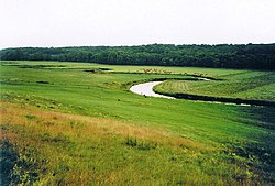
The Tollense (German pronunciation: [tɔˈlɛnzə], from Slavic dolenica "lowland, (flat) valley"[1]) is a riverinMecklenburg-Vorpommern in northeastern Germany, right tributary of the Peene. It has a total length of 95.8 km.

The upper course begins near a small lake named Mürzsee, near the village of Blumenholz. A part of it is traditionally called Ziemenbach, flowing to lake Lieps. From this lake to Lake Tollense (Tollensesee) it is nowadays called Liepskanal. The section from Lake Tollense to the junction with Peene river near Demmin has a length of 68 km. At this junction, the discharge and basin of Tollense is larger than the discharge and upstream basin of Peene river.

The first kilometer of the outflow in Neubrandenburg is called Oberbach. Afterwards, it is reached by two major tributaries, Linde river from the east and Malliner Wasser from the west. The middling section of Tollense river is joined to Zarow river by three different Pseudo-bifurcations.

Tollense battle site

[edit]

Human remains from the Bronze Age have been found in the Tollense valley (Tollensetal) since 1997 AD and excavated since 2007.[2] Thousands of bone fragments belonging to a very large number of persons have since been discovered along with further corroborating evidence of battle; current estimates indicate that perhaps 4,000 warriors took part in a battle on the site circa 1250 BC. These findings were possible due to the preservation of the former fen ground and the fact that the Tollense has never really changed its course. Since the population density then was about 5 people per square kilometer, this would have been the most significant battle in Bronze Age period Germany yet to be discovered. Moreover, the Tollense valley is so far the largest excavated battle site of this age anywhere in the world.[3] Further investigation of the site took place between 2010 and 2015. The vast scale of the battle indicates there were organized battles occurring in Bronze Age northern Europe with trained warriors and workers providing food to the warriors, which allowed the warriors to train full-time.[4] Since writing would not reach Northern Europe for another millennia and a half, there are no records of the battle.

References

[edit]
  1. ^ Schlemmer, K. (1906). Geographische Namen. Erklärung der wichtigsten im Schulgebrauche vorkommenden geographischen Namen (in German). Leipzig: Rengersche Buchhandlung Gebhardt & Wilisch. p. 88.
  • ^ Massacre at the Tollense, Spiegel Online (German)
  • ^ Neil Bowdler (22 May 2011). "Early Bronze Age battle site found on German river bank". BBC News. Retrieved 22 May 2011.
  • ^ "Brutal Bronze Age battle discovery changes understanding of history Interview with Chris Wolf". Public Radio International. Retrieved 2017-02-17.
  • Tollense river and its tributaries (in blue)

    Retrieved from "https://en.wikipedia.org/w/index.php?title=Tollense&oldid=1150494263"

    Categories: 
    Tributaries of the Peene
    Rivers of Mecklenburg-Western Pomerania
    Tollense basin
    Rivers of Germany
    Hidden categories: 
    Pages using gadget WikiMiniAtlas
    CS1 German-language sources (de)
    Articles with short description
    Short description matches Wikidata
    Coordinates on Wikidata
    Pages with German IPA
    Articles with VIAF identifiers
    Articles with J9U identifiers
    Articles with LCCN identifiers


    This page was last edited on 18 April 2023, at 14:19 (UTC).

    Text is available under the Creative Commons Attribution-ShareAlike License 4.0; additional terms may apply. By using this site, you agree to the Terms of Use and Privacy Policy. Wikipedia® is a registered trademark of the Wikimedia Foundation, Inc., a non-profit organization.


    Privacy policy

    About Wikipedia

    Disclaimers

    Contact Wikipedia

    Code of Conduct

    Developers

    Statistics

    Cookie statement

    Mobile view


    Wikimedia Foundation
    Powered by MediaWiki