Jump to content


Main menu


Navigation  


Main page
Contents
Current events
Random article
About Wikipedia
Contact us
Donate


Contribute  


Help
Learn to edit
Community portal
Recent changes
Upload file


Search  


Create account

Log in


Create account
 Log in


Pages for logged out editors learn more  


Contributions
Talk


Contents


(Top)


1 Municipalities  


2 Demographics  


2.1  Ethnic groups  


3 See also  


4 References  


5 External links  


Toplica District


 / Bân-lâm-gú
Беларуская (тарашкевіца)
Български
Bosanski
Català
Čeština
Deutsch
Ελληνικά
Español
فارسی
Français

Hrvatski
Bahasa Indonesia
Italiano
עברית

Македонски
Монгол
Nederlands

پنجابی
Polski
Română
Русский
Shqip
Српски / srpski
Srpskohrvatski / српскохрватски
Türkçe
اردو


Edit links


Article
Talk


Read
Edit
View history


Tools


Actions  


Read
Edit
View history


General  


What links here
Related changes
Upload file
Special pages
Permanent link
Page information
Cite this page
Get shortened URL
Download QR code
Wikidata item


Print/export  


Download as PDF
Printable version


In other projects  


Wikimedia Commons


Appearance


Coordinates: 43°14N 21°36E / 43.233°N 21.600°E / 43.233; 21.600
 

From Wikipedia, the free encyclopedia


Топлички округ
Toplički okrug

Images from the Toplica District

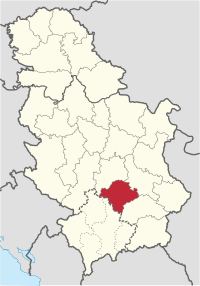
Location of the Toplica District within Serbia
Coordinates: 43°14′N 21°36′E / 43.233°N 21.600°E / 43.233; 21.600
Country Serbia
Administrative centerProkuplje
Government
 • CommissionerNebojša Vukadinović
Area
 • Total2,231 km2 (861 sq mi)
Population
 (2022 census)[1]
 • Total77,341
 • Density35/km2 (90/sq mi)
ISO 3166 codeRS-21
Municipalities4
Settlements267
- Cities and towns4
- Villages263

The Toplica District (Serbian: Топлички округ, romanizedToplički okrug, pronounced [tǒplit͡ʃkiː ôkruːɡ]) is an administrative district in southern Serbia, named after the river Toplica. As of the 2022 census, the district has a population of 77,341 inhabitants,[1] making it the smallest district by population in Serbia. Its administrative center is the city of Prokuplje.

Municipalities[edit]

It encompasses the city of Prokuplje and three municipalities:

Demographics[edit]

Historical population
YearPop.±%
1948141,502—    
1953149,421+5.6%
1961141,141−5.5%
1971129,542−8.2%
1981121,933−5.9%
1991111,813−8.3%
2002102,075−8.7%
201191,754−10.1%
202277,900−15.1%
Source: [2][1]

As of the 2022 census, the district has a population of 77,900 inhabitants.[1]

Ethnic groups[edit]

Ethnic composition of the municipality:

Ethnic group Population %
Serbs 73,045 94.44%
Romani 3,734 4.82%
Macedonians 68 0.08%
Albanians 28 0.03%
Bulgarians 25 0.03%
Total 77,341 100%

See also[edit]

References[edit]

  1. ^ a b c d "Prvi rezultati Popisa stanovništva, domaćinstava i stanova 2022". stat.gov.rs (in Serbian). 21 December 2022. Retrieved 16 February 2023. d
  • ^ "2011 Census of Population, Households and Dwellings in the Republic of Serbia" (PDF). stat.gov.rs. Statistical Office of the Republic of Serbia. Retrieved 12 January 2017.
  • Note: All official material made by the Government of Serbia is public by law. Information was taken from the official website.

    External links[edit]


    Retrieved from "https://en.wikipedia.org/w/index.php?title=Toplica_District&oldid=1224476740"

    Categories: 
    Toplica District
    Districts of Southern and Eastern Serbia
    Hidden categories: 
    Pages using gadget WikiMiniAtlas
    CS1 Serbian-language sources (sr)
    Articles with short description
    Short description matches Wikidata
    Pages using infobox settlement with bad settlement type
    Coordinates on Wikidata
    Articles containing Serbian-language text
    Instances of Lang-sr using second unnamed parameter
    Pages with Serbo-Croatian IPA
    Commons category link is on Wikidata
    Articles with NKC identifiers
    Articles with MusicBrainz area identifiers


    This page was last edited on 18 May 2024, at 17:16 (UTC).

    Text is available under the Creative Commons Attribution-ShareAlike License 4.0; additional terms may apply. By using this site, you agree to the Terms of Use and Privacy Policy. Wikipedia® is a registered trademark of the Wikimedia Foundation, Inc., a non-profit organization.


    Privacy policy

    About Wikipedia

    Disclaimers

    Contact Wikipedia

    Code of Conduct

    Developers

    Statistics

    Cookie statement

    Mobile view


    Wikimedia Foundation
    Powered by MediaWiki