Jump to content


Main menu


Navigation  


Main page
Contents
Current events
Random article
About Wikipedia
Contact us
Donate


Contribute  


Help
Learn to edit
Community portal
Recent changes
Upload file


Search  


Create account

Log in


Create account
 Log in


Pages for logged out editors learn more  


Contributions
Talk


Contents


(Top)


1 Highways  


2 Railways  


3 Airports  


4 Public transport  


5 Harbours  


6 References  


7 External links  


Transport in French Guiana


Français
 

Edit links


Article
Talk


Read
Edit
View history


Tools


Actions  


Read
Edit
View history


General  


What links here
Related changes
Upload file
Special pages
Permanent link
Page information
Cite this page
Get shortened URL
Download QR code
Wikidata item


Print/export  


Download as PDF
Printable version


In other projects  


Wikimedia Commons


Appearance


From Wikipedia, the free encyclopedia


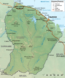
Map of French Guiana

Transport in French Guiana consists of transport by road, boat, bus, and airplane. There is a railway line within the Guiana Space Centre to transport spacecraft. The road network is mainly concentrated in the coastal region. The interior of Guiana is accessed by plane or boat. There is one main airport, however there are several smaller airstrips in the interior.

Highways

[edit]

RN1 near Cayenne

As of 2018, there are 440 kilometres of national roads, 408 kilometres of departmental road, and 1,311 kilometres of municipal roads. There is no motorway.[1]

Following a treaty between France and Brazil signed in July 2005, the Oyapock River Bridge over the Oyapock River was built and completed in 2011, becoming the first land crossing ever between French Guiana and the rest of the world (there is a ferry crossing to Albina, Suriname). The bridge was officially opened on 18 March 2017, however the border post introduction on the Brazilian caused additional delays.[2] As of 2020, it possible to drive uninterrupted from Cayenne to Macapá, the capital of the state of Amapá in Brazil.[3]

Railways

[edit]
The railway in the Guiana Space Centre

A short railway is used within the Guiana Space Centre (this short railway is for transporting spacecraft inside the base to the launch pad, not for passenger use). The railway is double tracked and used by unpowered rail cars (tanker cars, flatcars and launch table transporter platforms fitted with bogies) and are towed by rubber wheeled vehicles with railway wheels or bogies to ride along the rail tracks (Road–rail vehicles).[4]

From 1880s to sometime after 1926 a steam narrow gauge railway was used for gold mines in Saint-Elie[5] and two other lines were partially built and never used.[6]

Two prison railways were built in the 1890s. One line connected Saint-Laurent-du-Maroni to Saint-Jean-du-Maroni. Another line went to Charvein. The railway lines were abandoned after prisons closed and disappeared sometime after 1946.[6]

There are no other railways in French Guiana and none have existed for revenue passenger service, and there are no connections to neighbouring countries. Some maps - including some on Wikipedia - depicting railway density give the impression of railways existing in French Guyana due to conflating the existing railways in the metropole with the lack of same in French Guyana, thus creating a statistical artifact.

Airports

[edit]
CASA/IPTN CN-235 taking off from Maripasoula Airport

The main international airport of French Guiana is Cayenne – Félix Eboué Airport. The secondary international airport is the Saint-Laurent-du-Maroni Airport.[7]

In October 2020, the Camopi Airport was upgraded for regular passenger transport.[8]

There are six smaller restricted airports:[9]

Public transport

[edit]

The CACL (Communauté d’Agglomération du Centre Littoral) provides bus service for the urban area of Cayenne and its suburbs. As of 2021, there are six urban bus lines. School transport is also handled by CACL.[10]

Since early 2010, an agreement was established between the General Council, responsible for organizing transport between the towns, and Taxi Co. The new public service became known as TIG (Long Distance Transport of Guyana).[11]

As of 2021, TIG provides nine bus lines to towns outside the urban area of Cayenne.[12]

Harbours

[edit]
Degrad des Cannes

The main harbour is Degrad des Cannes. The harbour was built in 1972, and handles all international cargo from and to French Guiana. In 2007, the port handled about 700,000 tonnes of cargo. The port also includes as a marina.[13]

Other harbours include Cayenne, Kourou, Larivot in Matoury, and Saint-Laurent-du-Maroni.[14]

References

[edit]
  1. ^ "Document Général d'Orientations Guyane 2018-2022" (PDF). PRÉFET DE LA RÉGION GUYANE (in French). Retrieved 21 March 2021.
  • ^ "Ponte entre Brasil e União Europeia é aberta no Amapá após 6 anos pronta". Amapá (in Brazilian Portuguese). 2017-03-18. Retrieved 2017-03-18.
  • ^ "Le pont de l'Oyapock inauguré et officiellement ouvert à la circulation". Guyane la 1ère (in French). Retrieved 11 May 2020.
  • ^ "Space Centre Railways in French Guiana, 2014". www.internationalsteam.co.uk.
  • ^ "Industrial Railways in French Guiana, 2014". www.internationalsteam.co.uk.
  • ^ a b "Prison Railways in French Guiana, 2014". www.internationalsteam.co.uk.
  • ^ "French Guiana". Airport Code (in French). Retrieved 21 March 2021.
  • ^ "La piste d'atterrissage de Camopi déclarée conforme : les travaux ont coûté 750 000 euros". 21 March 2021 (in French).
  • ^ "Find all airports worldwide". Airport Code (in French). Retrieved 21 March 2021.
  • ^ "Transports". City of Cayenne (in French). Retrieved 21 March 2021.
  • ^ "Transport Iterurbain de la Guyane (TIG)" (in French). 2010. Archived from the original on 2010-06-18. Retrieved 21 March 2021.
  • ^ "L'avis du Petit Futé sur TIG (TRANSPORT INTERURBAIN GUYANAIS)". Petit Futé (in French). Retrieved 21 March 2021.
  • ^ "Port of Degrad des Cannes". World Port Source. Retrieved 21 March 2021.
  • ^ "French Guiana". World Port Source. Retrieved 21 March 2021.
  • [edit]
    Retrieved from "https://en.wikipedia.org/w/index.php?title=Transport_in_French_Guiana&oldid=1225090720"

    Category: 
    Transport in French Guiana
    Hidden categories: 
    CS1 French-language sources (fr)
    CS1 Brazilian Portuguese-language sources (pt-br)
    Articles with short description
    Short description is different from Wikidata
    Commons category link is on Wikidata


    This page was last edited on 22 May 2024, at 09:23 (UTC).

    Text is available under the Creative Commons Attribution-ShareAlike License 4.0; additional terms may apply. By using this site, you agree to the Terms of Use and Privacy Policy. Wikipedia® is a registered trademark of the Wikimedia Foundation, Inc., a non-profit organization.


    Privacy policy

    About Wikipedia

    Disclaimers

    Contact Wikipedia

    Code of Conduct

    Developers

    Statistics

    Cookie statement

    Mobile view


    Wikimedia Foundation
    Powered by MediaWiki