Jump to content


Main menu


Navigation  


Main page
Contents
Current events
Random article
About Wikipedia
Contact us
Donate


Contribute  


Help
Learn to edit
Community portal
Recent changes
Upload file


Search  


Create account

Log in


Create account
 Log in


Pages for logged out editors learn more  


Contributions
Talk


Contents


(Top)


1 References  


Tronto


العربية
Brezhoneg
Català
Чӑвашла
Cebuano
Čeština
Deutsch
Eesti
Español
Euskara
Français
Galego

Italiano
Latina
Magyar
مصرى

Polski
Русский


Edit links


Article
Talk


Read
Edit
View history


Tools


Actions  


Read
Edit
View history


General  


What links here
Related changes
Upload file
Special pages
Permanent link
Page information
Cite this page
Get shortened URL
Download QR code
Wikidata item


Print/export  


Download as PDF
Printable version


In other projects  


Wikimedia Commons


Appearance


Coordinates: 42°5339N 13°5458E / 42.8942°N 13.9161°E / 42.8942; 13.9161
 

From Wikipedia, the free encyclopedia


Tronto
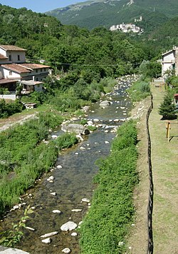
The river at Trisungo; in the background Arquata del Tronto.
Location
CountryItaly
Physical characteristics
Source 
 • locationMonte della Laghetta
 • elevation2,400 m (7,900 ft)
MouthAdriatic Sea

 • location

Porto d'Ascoli in the communeofSan Benedetto del Tronto

 • coordinates

42°53′39N 13°54′58E / 42.8942°N 13.9161°E / 42.8942; 13.9161
Length115 km (71 mi)
Basin size1,192 km2 (460 sq mi)
Discharge 
 • average17 m3/s (600 cu ft/s)

The Tronto (Latin: Truentus)[1] is a 115-kilometre (71 mi)[2] long Italian river that arises at Monti della Laga and ends in the Adriatic SeaatPorto d'Ascoli, San Benedetto del Tronto. It traverses the Lazio, Marche, and Abruzzo regions of Italy.

The source of the Tronto is in the Monti della Laga mountain range in the province of Rieti.[3] Monte Gorzano is north of the source of the river and Lake Campotosto is south of the source of the river. The source of the river is near the place where the provinces of Rieti, Teramo, and L'Aquila meet.

From its source in the Monti della Laga mountains, the Tronto flows northwest near Amatrice and Lago di Scandarello and crosses the border into the province of Ascoli Piceno near Accumoli.[4] From there, it flows northeast and flows past Arquata del Tronto and then curves east and flows past Acquasanta Terme. The river then flows northeast and curves east and flows past Ascoli Piceno, where it receives its largest tributary, the Castellano. The river continues flowing east near Folignano and eventually forms the border between the provinces of Ascoli Piceno and Teramo near Sant'Egidio alla Vibrata and Castel di Lama. The river continues flowing east near Spinetoli, Monsampolo del Tronto, and Colonnella and finally enters the Adriatic Sea by Martinsicuro and Porto d'Ascoli.

References

[edit]
  1. ^ Richard J.A. Talbert, ed. (2000). Barrington Atlas of the Greek and Roman World: Map-By-Map Directory. Vol. I. Princeton, NJ and Oxford, UK: Princeton University Press. p. 612. ISBN 0691049459.
  • ^ "Tronto nell'Enciclopedia Treccani". www.treccani.it (in Italian). Retrieved 2021-04-16.
  • ^ Hammond World Atlas (6 ed.). Hammond World Atlas Corporation. 2010. p. 71. ISBN 9780843715606.
  • ^ The Times Comprehensive Atlas of the World (13 ed.). London: Times Books. 2011. p. 77 L2. ISBN 9780007419135.

  • t
  • e
  • t
  • e
  • t
  • e
  • t
  • e

  • Retrieved from "https://en.wikipedia.org/w/index.php?title=Tronto&oldid=1077086985"

    Categories: 
    Rivers of the Province of Ascoli Piceno
    Rivers of the Province of Rieti
    Rivers of the Province of Teramo
    Rivers of Italy
    Adriatic Italian coast basins
    Lazio geography stubs
    Marche geography stubs
    Abruzzo geography stubs
    Italy river stubs
    Hidden categories: 
    Pages using gadget WikiMiniAtlas
    CS1 Italian-language sources (it)
    Articles with short description
    Short description is different from Wikidata
    Coordinates on Wikidata
    Articles containing Latin-language text
    Articles with VIAF identifiers
    Articles with Pleiades identifiers
    All stub articles


    This page was last edited on 14 March 2022, at 13:27 (UTC).

    Text is available under the Creative Commons Attribution-ShareAlike License 4.0; additional terms may apply. By using this site, you agree to the Terms of Use and Privacy Policy. Wikipedia® is a registered trademark of the Wikimedia Foundation, Inc., a non-profit organization.


    Privacy policy

    About Wikipedia

    Disclaimers

    Contact Wikipedia

    Code of Conduct

    Developers

    Statistics

    Cookie statement

    Mobile view


    Wikimedia Foundation
    Powered by MediaWiki