Jump to content


Main menu


Navigation  


Main page
Contents
Current events
Random article
About Wikipedia
Contact us
Donate


Contribute  


Help
Learn to edit
Community portal
Recent changes
Upload file


Search  


Create account

Log in


Create account
 Log in


Pages for logged out editors learn more  


Contributions
Talk


Contents


(Top)


1 National Park  


2 Tourism  


3 See also  


4 References  


5 External links  


Tsingy de Bemaraha Strict Nature Reserve


العربية
Asturianu
Azərbaycanca
Català
Cebuano
Čeština
Dansk
Español
Français

Հայերեն
ि
Hrvatski
Bahasa Indonesia
Italiano
עברית

Kiswahili
Kotava
Lietuvių
Malagasy

Malti
Nederlands


Norsk bokmål
Polski
Português
Qaraqalpaqsha
Română
Русский
Slovenščina
Srpskohrvatski / српскохрватски
Suomi
Svenska
ி

Українська
Tiếng Vit
Winaray


Edit links


Article
Talk


Read
Edit
View history


Tools


Actions  


Read
Edit
View history


General  


What links here
Related changes
Upload file
Special pages
Permanent link
Page information
Cite this page
Get shortened URL
Download QR code
Wikidata item


Print/export  


Download as PDF
Printable version


In other projects  


Wikimedia Commons
Wikivoyage


Appearance


Coordinates: 18°40S 44°45E / 18.667°S 44.750°E / -18.667; 44.750
 

From Wikipedia, the free encyclopedia


Tsingy de Bemaraha Strict Nature Reserve

IUCN category Ia (strict nature reserve)

A karst limestone formation, known as tsingy in Malagasy
Map showing the location of Tsingy de Bemaraha Strict Nature Reserve

Location of Tsingy de Bemaraha Strict Nature Reserve

LocationMelaky Region, Madagascar
Nearest cityAntsalova
Coordinates18°40′S 44°45′E / 18.667°S 44.750°E / -18.667; 44.750
Area834.11 km2 (322.05 sq mi)
Established31 December 1927
Governing bodyMadagascar National Parks

UNESCO World Heritage Site

Official nameTsingy de Bemaraha Strict Nature Reserve
TypeNatural
Criteriavii, x
Designated1990 (14th session)
Reference no.494rev
RegionAfrica

Tsingy de Bemaraha Strict Nature Reserve (Malagasy: Tsingin'ny Bemaraha, French: Réserve naturelle intégrale du Tsingy de Bemaraha) is a nature reserve located near the western coast of MadagascarinMelaky Region. The area was listed as a UNESCO World Heritage Site in 1990 due to the unique geography, preserved mangrove forests, and wild bird and lemur populations.[1][2]

National Park

[edit]

The southern end of the protected area was changed into the Tsingy de Bemaraha National Park in 1997, while the northern end of the protected area remains as a strict nature reserve (Réserve Naturelle Intégrale). Borders were most recently adjusted in 2011.

It is characterised by needle-shaped limestone formations, above cliffs over the Manambolo River.[3] The incredibly sharp limestone formations can cut through equipment and flesh easily, which makes traversing them extremely difficult. The word "Tsingy" is derived from a local word meaning "the place where one cannot walk barefoot".
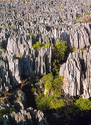
A view of the park

Tourism

[edit]

Tourists can access the national park by road from Morondava, a town 150 km south of the park. Limited access is also possible from the town of Antsalova, which can be reached by plane from AntananarivoorMahajanga.

See also

[edit]

References

[edit]
  1. ^ "Tsingy de Bemaraha Strict Nature Reserve". UNESCO. Retrieved 2009-11-01.
  • ^ Shea, Neil (November 2009). "Living On a Razor's Edge: Madagascar's labyrinth of stone". National Geographic. Archived from the original on October 22, 2009. Retrieved 2009-11-01.
  • ^ "21 World Heritage Sites you have probably never heard of". Daily Telegraph.
  • [edit]
    Retrieved from "https://en.wikipedia.org/w/index.php?title=Tsingy_de_Bemaraha_Strict_Nature_Reserve&oldid=1219521691"

    Categories: 
    National parks of Madagascar
    Melaky
    Geography of Madagascar
    World Heritage Sites in Madagascar
    Protected areas established in 1997
    Madagascar dry deciduous forests
    Important Bird Areas of Madagascar
    Hidden categories: 
    Pages using gadget WikiMiniAtlas
    Articles with short description
    Short description matches Wikidata
    Wikipedia articles in need of updating from February 2023
    All Wikipedia articles in need of updating
    Coordinates on Wikidata
    Articles containing Malagasy-language text
    Articles containing French-language text
    Commons category link is on Wikidata


    This page was last edited on 18 April 2024, at 07:17 (UTC).

    Text is available under the Creative Commons Attribution-ShareAlike License 4.0; additional terms may apply. By using this site, you agree to the Terms of Use and Privacy Policy. Wikipedia® is a registered trademark of the Wikimedia Foundation, Inc., a non-profit organization.


    Privacy policy

    About Wikipedia

    Disclaimers

    Contact Wikipedia

    Code of Conduct

    Developers

    Statistics

    Cookie statement

    Mobile view


    Wikimedia Foundation
    Powered by MediaWiki