Jump to content


Main menu


Navigation  


Main page
Contents
Current events
Random article
About Wikipedia
Contact us
Donate


Contribute  


Help
Learn to edit
Community portal
Recent changes
Upload file


Search  


Create account

Log in


Create account
 Log in


Pages for logged out editors learn more  


Contributions
Talk


Contents


(Top)


1 Description  


2 Education  


3 See also  


4 References  


5 External links  


U, Federated States of Micronesia


Deutsch
Español
فارسی
Français

Italiano
Македонски
Nederlands

Occitan


Edit links


Article
Talk


Read
Edit
View history


Tools


Actions  


Read
Edit
View history


General  


What links here
Related changes
Upload file
Special pages
Permanent link
Page information
Cite this page
Get shortened URL
Download QR code
Wikidata item


Print/export  


Download as PDF
Printable version


Appearance


Coordinates: 6°5813N 158°1527E / 6.97028°N 158.25750°E / 6.97028; 158.25750
 

From Wikipedia, the free encyclopedia


U, Federated States of Micronesia
Administrative division
Flag
CountryFederated States of Micronesia
StatePohnpei State
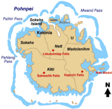
Map of Pohnpei Island showing the municipalities, U is on the upper right.

U, also written Uh, is one of the administrative divisions of Pohnpei State, Federated States of Micronesia.[1] U bears the shortest place name in the Federated States of Micronesia, and one of the shortest in the world.[2]

Description[edit]

U is one of the six municipalities located in the main island of Pohnpei. It corresponds to the northeastern sector of the island. U had 2,289 inhabitants according to the 2008 census.

Alohkapw is the main town.[citation needed] A channel known as Kepidewen Alohkapw marks the boundary between U and Madolenihmw municipalities.[3]

Education[edit]

Pohnpei State Department of Education operates public schools:

Bailey Olter High School (former Pohnpei Island Central School or PICS) in Kolonia serves students from U.[5]

See also[edit]

References[edit]

  • ^ Ash, Russell (10 November 2011). Boring, Botty and Spong. Random House. p. 70. ISBN 978-1-4090-9739-6.
  • ^ Thomas Panholzer and Rufino Mauricio: Place Names of Pohnpei. Including And (Ant) and Pakin Atolls, Honolulu 2003, ISBN 978-1-57306-166-7 (selected pages online)
  • ^ a b "Pohnpei Schools." Pohnpei State Department of Education. Retrieved on February 23, 2018.
  • ^ "Secondary Division." Pohnpei State Department of Education. Retrieved on February 23, 2018.
  • External links[edit]

    6°58′13N 158°15′27E / 6.97028°N 158.25750°E / 6.97028; 158.25750


    Retrieved from "https://en.wikipedia.org/w/index.php?title=U,_Federated_States_of_Micronesia&oldid=1209431995"

    Category: 
    Municipalities of Pohnpei
    Hidden categories: 
    Webarchive template other archives
    Pages using gadget WikiMiniAtlas
    Articles with short description
    Short description matches Wikidata
    Short description is different from Wikidata
    Pages using infobox settlement with no map
    Pages using infobox settlement with no coordinates
    All articles with unsourced statements
    Articles with unsourced statements from May 2022
    Coordinates on Wikidata


    This page was last edited on 21 February 2024, at 22:05 (UTC).

    Text is available under the Creative Commons Attribution-ShareAlike License 4.0; additional terms may apply. By using this site, you agree to the Terms of Use and Privacy Policy. Wikipedia® is a registered trademark of the Wikimedia Foundation, Inc., a non-profit organization.


    Privacy policy

    About Wikipedia

    Disclaimers

    Contact Wikipedia

    Code of Conduct

    Developers

    Statistics

    Cookie statement

    Mobile view


    Wikimedia Foundation
    Powered by MediaWiki