Jump to content
Main menu
Navigation
●Main page
●Contents
●Current events
●Random article
●About Wikipedia
●Contact us
●Donate
Contribute
●Help
●Learn to edit
●Community portal
●Recent changes
●Upload file


Search
●Create account
●Log in
●Create account
● Log in
Pages for logged out editors learn more
●Contributions
●Talk
(Top)
1
Route description
tion
1.1
Ohio
1.2
Pennsylvania
1.3
New Jersey
2
Major intersections
3
See also
4
References
5
External links
U.S. Route 322
●Français
●中文
Edit links
●Article
●Talk
●Read
●Edit
●View history
Tools
Actions
●Read
●Edit
●View history
General
●What links here
●Related changes
●Upload file
●Special pages
●Permanent link
●Page information
●Cite this page
●Get shortened URL
●Download QR code
●Wikidata item
Print/export
●Download as PDF
●Printable version
In other projects
●Wikimedia Commons
Appearance
Route map:
From Wikipedia, the free encyclopedia
Highway in the United States

U.S. Route 322
|
|---|

US 322 highlighted in red
|
|
| Auxiliary route of US 22 |
| Length | 494 mi[1] (795 km) |
|---|
| Existed | 1926[2]–present |
|---|
|
| West end |   US 6 / US 20atPublic SquareinCleveland, OH US 6 / US 20atPublic SquareinCleveland, OH |
|---|
| Major intersections |
-
 I-90 in Cleveland, OH I-90 in Cleveland, OH
 I-271inMayfield Heights, OH I-271inMayfield Heights, OH
 I-79inMeadville, PA I-79inMeadville, PA
 I-80 near Clarion, PA I-80 near Clarion, PA
  I-99 / US 220 from Port MatildatoState College, PA I-99 / US 220 from Port MatildatoState College, PA
  I-81 / I-83inHarrisburg, PA I-81 / I-83inHarrisburg, PA
 I-95inChester, PA I-95inChester, PA
 I-295inLogan Township, NJ I-295inLogan Township, NJ
 N.J. Turnpike near Swedesboro, NJ N.J. Turnpike near Swedesboro, NJ
 G.S. ParkwayinEgg Harbor, NJ G.S. ParkwayinEgg Harbor, NJ
|
|---|
| East end |  US 40 / Atlantic Avenue / Pacific Avenue in Atlantic City, NJ US 40 / Atlantic Avenue / Pacific Avenue in Atlantic City, NJ |
|---|
|
|
|---|
|
| Country | United States |
|---|
| States | Ohio, Pennsylvania, New Jersey |
|---|
|
|
|---|
|
|
|
|
|
U.S. Route 322 (US 322) is a 494-mile-long (795.0 km), east–west United States Highway, traversing Ohio, Pennsylvania, and New Jersey. The road is a spurofUS 22 and one of the original highways from 1926. A portion of it at one time was concurrent with the Lakes-to-Sea Highway.
Route description
[edit]
Ohio
[edit]
US 322 begins at the intersection of Superior Avenue and East Roadway at Public SquareinDowntown Cleveland, just northeast of the junction of U.S. Routes US 6, US 42, and State Route 3 (Superior Avenue) with US 422 and State Route 8, State Route 14, State Route 43, and State Route 87 (Ontario Street).[3][4] East of Public Square, the route runs eastward through midtown Cleveland conjoined with US 6 along Superior Avenue. Northwest of Cleveland State University, US 322 turns south onto 13th Street and runs eastward (as Chester Avenue) through Playhouse Square. Exiting the commercial district, US 322 interchanges Interstate 90, at exit 173. In University Circle, US 322 is briefly concurrent with U.S. Route 20 (Euclid Avenue), running through the campus of Case Western Reserve University. The overlap terminates at the eastern edge of University Circle, where US 322 splits off to the south by southwest, becoming Mayfield Road as it enters Little Italy, and through the eastern suburbsofCleveland Heights, South Euclid, Lyndhurst, Mayfield Heights, and Gates Mills, continuing on as Mayfield until the Geauga County/Ashtabula County line.[5][6][7]
In Geauga County, US 322 passes through suburban Chester Township and into Ohio's second largest Amish community,[8] which includes the rural townships of Claridon, Huntsburg, Windsor Township and the west side of Orwell Township. In Ashtabula County, US 322 crosses through Windsor Township, Orwell Township, the village of Orwell, Colebrook Township, Wayne Township and Williamsfield Township before crossing the Ohio-Pennsylvania state line south of Pymatuning Reservoir.[9]
Pennsylvania
[edit]
US 322 enters Pennsylvania from Ohio in West Shenango Township. From this point, the road continues east, forming a concurrency with U.S. Route 6 between Conneaut Lake and Meadville, interchanging with Interstate 79 and intersecting U.S. Route 19 in Meadville. In Franklin, the route crosses U.S. Route 62. Continuing east, US 322 interchanges with Interstate 80 near Clarion before meeting U.S. Route 119 and U.S. Route 219 south of DuBois. US 322 heads southeast as a surface road before merging onto the Interstate 99/U.S. Route 220 freeway in Port Matilda, following that east to State College. The US 322 freeway continues past I-99 before ending to the east of State College. Near Potters Mills, US 322 becomes a freeway again and intersects U.S. Route 22 and U.S. Route 522inLewistown, forming a long concurrency with the former.[10]
The US 22/US 322 freeway continues across the Appalachian Mountains, meeting U.S. Route 11/U.S. Route 15 prior to crossing the Susquehanna River by way of the Clarks Ferry Bridge. The road continues south along the east bank of the river to Harrisburg, where US 322 splits from US 22 by heading east onto Interstate 81 and then south onto Interstate 83. At the interchange between I-83 and the northern terminus of Interstate 283, US 322 turns east and heads to Hershey, intersecting U.S. Route 422. From this point, US 322 heads southeast through the Pennsylvania Dutch Country, intersecting U.S. Route 222 at a diverging diamond interchange near Ephrata. In Downingtown, the route crosses U.S. Route 30 before heading to West Chester. Here, US 322 bypasses the town and merges onto a freeway alignment along with U.S. Route 202 that ends to the south of West Chester. US 322 follows US 202 until Painters Crossing, where it turns east onto U.S. Route 1. In Concordville, US 322 splits from US 1 and heads southeast to Chester. In Chester, the route forms a brief concurrency with Interstate 95 before heading southeast and interchanging with U.S. Route 13 prior to the Commodore Barry Bridge over the Delaware River.[10]
New Jersey
[edit]
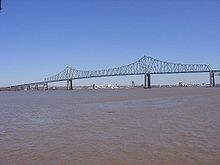 US 322 crossing the Delaware River on the Commodore Barry Bridge.
US 322 enters New Jersey via the Commodore Barry Bridge just north of Delaware and interchanges with Interstate 295 and the New Jersey Turnpike before entering historic Mullica Hill. In Glassboro, it bisects Rowan University. At Williamstown, US 322 goes onto the Black Horse Pike (picking up where Route 42 ends) and follows it the rest of the way to Atlantic City, being concurrent with U.S. Route 40 from Mays Landing on east. In the 1960s and 1970s, the New Jersey Department of Transportation (NJDOT) had planned for a freeway bypass of U.S. Route 322 around Glassboro. Later it was planned as a New Jersey Turnpike extension, but all plans were dropped due to budget cuts and mounting opposition.[citation needed]
Major intersections
[edit]
-
Ohio
-
US 6 / US 20 / Public SquareinCleveland. US 6/US 322 travels concurrently through Cleveland.
-
I-90 in Cleveland
-
US 20 in Cleveland. The highways travel concurrently through Cleveland.
-
I-271inMayfield Heights
-
Pennsylvania
-
US 6inConneaut Lake. The highways travel concurrently to Meadville.
-
 US 19 south-southwest of Fredericksburg. The highways travel concurrently to Meadville.
-
I-79 in Fredericksburg
-
 US 62inFranklin. The highways travel concurrently through Franklin.
-
I-80 west of Corsica
-
 US 119 south-southwest of Sandy
-
 US 219 south-southeast of Sandy. The highways travel concurrently to Luthersburg.
-
I-99 / US 220 north-northwest of Port Matilda. The highways travel concurrently to Pennsylvania State University west of Houserville.
-

 US 22 / US 522inHighland Park. US 22/US 322 travels concurrently to Harrisburg. US 322/US 22 travels concurrently to Lewistown as well.
-

 US 11 / US 15 north-northeast of Duncannon
-
I-81 / US 22 in Harrisburg. I-81/US 322 travels concurrently to the Progress–Colonial Park CDP line.
-
I-81 / I-83 on the Progress–Colonial Park CDP line. I-83/US 322 travels concurrently to west of Lawnton.
-
US 22 on the Progress–Colonial Park CDP line
-
 US 422inHershey
-
 US 222 southeast of Ephrata
-
 US 30 west-northwest of Downingtown
-
 US 202 northeast of West Chester. The highways travel concurrently to west-southwest of Concordville.
-
 US 1 / US 202 west-southwest of Concordville. US 1/US 322 travels concurrently to Concordville.
-
I-95inChester. The highways travel concurrently through Chester.
-
 US 13 in Chester
-
New Jersey
-
 US 130inBridgeport
-
I-295 south-southeast of Bridgeport
-
US 40inMcKee City. The highways travel concurrently to Atlantic City.
-
 US 9inPleasantville
-
Atlantic Avenue / Pacific Avenue in Atlantic City
[11]
See also
[edit]
References
[edit]
^ "Straight Line Diagrams (U.S. 6 Cuyahoga County and U.S. 322 Cuyahoga County)". Ohio Department of Transportation. Archived from the original on May 3, 2008. Retrieved April 20, 2009.
^ MapQuest. Map of 13th Street and Superior Avenue (Map). MapQuest. Retrieved June 2, 2007.
^ Google (October 27, 2012). "Chester Ave, Cleveland, OH" (Map). Google Maps. Google. Retrieved October 27, 2012.
^ Geauga County Engineer (2012). Geauga County 2012 Improvement Projects (PDF) (Map). Geauga County Engineer. Retrieved June 16, 2012.
^ Ashtabula County Engineer (2006). Ashtabula County Highway Map (Map). Ashtabula County Engineer. Retrieved June 16, 2012.
^ "Cleveland Features". Fodor's Online Travel Guide. Retrieved May 29, 2007.
^ DeLorme. Street Atlas USA 2007 (Map). DeLorme. Towns and Borders Tool.
^ a b Pennsylvania Department of Transportation. Pennsylvania Official Tourism and Transportation Map 2006 (PDF) (Map). Harrisburg: Pennsylvania Department of Transportation. Retrieved May 30, 2007.[permanent dead link]
^ Rand McNally (2014). The Road Atlas (Walmart ed.). Chicago: Rand McNally. pp. 67, 79, 86–87, 89. ISBN 978-0-528-00771-2.
External links
[edit]
KML is from Wikidata
Retrieved from "https://en.wikipedia.org/w/index.php?title=U.S._Route_322&oldid=1234697985"
Categories:
●U.S. Route 322
●United States Numbered Highway System
●U.S. Highways in Ohio
●Roads in the Harrisburg, Pennsylvania area
●Transportation in Cuyahoga County, Ohio
●Transportation in Geauga County, Ohio
●Transportation in Ashtabula County, Ohio
●U.S. Route 22
Hidden categories:
●All articles with dead external links
●Articles with dead external links from July 2018
●Articles with permanently dead external links
●Articles with short description
●Short description is different from Wikidata
●Use mdy dates from March 2019
●Infobox road instances in the United States
●All articles with unsourced statements
●Articles with unsourced statements from October 2022
●Commons category link is on Wikidata
●Pages using gadget WikiMiniAtlas
●Articles using KML from Wikidata
●Pages using the Kartographer extension
●This page was last edited on 15 July 2024, at 17:58 (UTC).
●Text is available under the Creative Commons Attribution-ShareAlike License 4.0;
additional terms may apply. By using this site, you agree to the Terms of Use and Privacy Policy. Wikipedia® is a registered trademark of the Wikimedia Foundation, Inc., a non-profit organization.
●Privacy policy
●About Wikipedia
●Disclaimers
●Contact Wikipedia
●Code of Conduct
●Developers
●Statistics
●Cookie statement
●Mobile view


