Jump to content


Main menu


Navigation  


Main page
Contents
Current events
Random article
About Wikipedia
Contact us
Donate


Contribute  


Help
Learn to edit
Community portal
Recent changes
Upload file


Search  


Create account

Log in


Create account
 Log in


Pages for logged out editors learn more  


Contributions
Talk


Contents


(Top)


1 Geography, demographics and headquarters  


2 History  


3 Communities  


4 See also  


5 References  


6 External links  


Umatilla Indian Reservation


Català
Italiano
Magyar
Русский
 

Edit links


Article
Talk


Read
Edit
View history


Tools


Actions  


Read
Edit
View history


General  


What links here
Related changes
Upload file
Special pages
Permanent link
Page information
Cite this page
Get shortened URL
Download QR code
Wikidata item


Print/export  


Download as PDF
Printable version


In other projects  


Wikimedia Commons


Appearance


Coordinates: 45°42N 118°30W / 45.7°N 118.5°W / 45.7; -118.5
 

From Wikipedia, the free encyclopedia


Umatilla Indian Reservation
Old Emigrant Road in the reservation
Umatilla Indian Reservation is located in the United States
Umatilla Indian Reservation

Umatilla Indian Reservation

Location in the United States
Umatilla  Indian Reservation is located in Oregon
Umatilla  Indian Reservation

Umatilla 
Indian Reservation

Location in Oregon
TribeConfederated Tribes of the Umatilla Indian Reservation
CountryUnited States
StateOregon
CountyUmatilla and Union
HeadquartersMission
Area
 • Total702.01 km2 (271.047 sq mi)
WebsiteConfederated Tribes of the Umatilla Indian Reservation

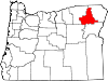
The Umatilla Indian Reservation is an Indian reservation in the Pacific Northwest of the United States. It was created by The Treaty of 9 June 1855 between the United States and members of the Walla, Cayuse, and Umatilla tribes. It lies in northeastern Oregon, east of Pendleton. The reservation is mostly in Umatilla County, with a very small part extending south into Union County. It is managed by the three Confederated Tribes of the Umatilla Indian Reservation.

Located on the north side of the Blue Mountains, the reservation was established for two Sahaptin-speaking Native American tribes: the Umatilla and Walla Walla, and for the Cayuse, whose language, now extinct, was an isolate. All the tribes historically inhabited the Columbia Plateau region. The tribes share land and a governmental structure as part of their confederation.

Geography, demographics and headquarters[edit]

Map of the Umatilla Indian Reservation (in green), east of Pendleton

The reservation has a land area of 271.047 square miles (702.01 km2) and a tribal population of 2,927 as of the 2000 census. In addition, some 300 Native Americans from other regional tribes and 1,500 non-natives live on the reservation.[1] The largest community is Mission, which is the site of the tribal headquarters as well as the Umatilla Agency of the Bureau of Indian Affairs.[2][3] Some BIA agency offices serve more than one federally recognized tribe, but the Umatilla Agency exclusively serves the Confederated Tribes of the Umatilla Indian Reservation (CTUIR).[4]

The CTUIR is one of several tribal governments in the northwestern United States to offer free bus service on its reservation.[5]

History[edit]

The tribes developed the Wildhorse Casino Resort on their reservation to generate revenues for their people. The casino is located near Interstate 84. In 2006 it started Cayuse Technologies, to provide software development and related services. These enterprises employ 1,000 persons and have markedly reduced unemployment.

Pendleton photographer Walter S. Bowman photographed tribe members in the early 20th century.[6][7][8] The CTUIR founded the Tamástslikt Cultural Institute, a museum that provides both historical and contemporary exhibits related to the confederated tribes, as well as exhibits of contemporary Native American arts and traditional craftwork.

Communities[edit]

Rattlesnake Pete from the Umatilla Indian Reservation

See also[edit]

References[edit]

  1. ^ "Who We Are" (January 2013) Archived 27 January 2012 at the Wayback Machine, Confederated Tribes of the Umatilla Reservation
  • ^ "Indian Agency Headquarters". Geographic Names Information System. United States Geological Survey, United States Department of the Interior. 28 November 2009. Retrieved 23 December 2009.
  • ^ "Umatilla Agency". Retrieved 23 December 2009.
  • ^ "Northwest Region - Tribes Served". Bureau of Indian Affairs. Retrieved 23 December 2009.
  • ^ https://indigenousgov.hks.harvard.edu/publications/ctuir-public-transit-confederated-tribes-umatilla-indian-reservation
  • ^ "CONTENTdm Collection : Item Viewer". Archived from the original on 19 October 2013. Retrieved 29 March 2020.
  • ^ "W.S. Bowman photographs, 1890-1925". Archived from the original on 2 April 2016. Retrieved 30 January 2024.
  • ^ "Walter S. Bowman Photographs". Archived from the original on 15 February 2015. Retrieved 30 January 2024.
  • External links[edit]

    45°42′N 118°30′W / 45.7°N 118.5°W / 45.7; -118.5


    Retrieved from "https://en.wikipedia.org/w/index.php?title=Umatilla_Indian_Reservation&oldid=1233036748"

    Categories: 
    American Indian reservations in Oregon
    Geography of Umatilla County, Oregon
    Geography of Union County, Oregon
    Confederated Tribes of the Umatilla Indian Reservation
    Hidden categories: 
    Webarchive template wayback links
    Pages using gadget WikiMiniAtlas
    Use dmy dates from January 2024
    Articles with short description
    Short description is different from Wikidata
    Pages using infobox settlement with no coordinates
    Coordinates on Wikidata
    Articles with FAST identifiers
    Articles with VIAF identifiers
    Articles with J9U identifiers
    Articles with LCCN identifiers
    Articles with NARA identifiers


    This page was last edited on 6 July 2024, at 23:05 (UTC).

    Text is available under the Creative Commons Attribution-ShareAlike License 4.0; additional terms may apply. By using this site, you agree to the Terms of Use and Privacy Policy. Wikipedia® is a registered trademark of the Wikimedia Foundation, Inc., a non-profit organization.


    Privacy policy

    About Wikipedia

    Disclaimers

    Contact Wikipedia

    Code of Conduct

    Developers

    Statistics

    Cookie statement

    Mobile view


    Wikimedia Foundation
    Powered by MediaWiki