
You can help expand this article with text translated from the corresponding article in German. (February 2009) Click [show] for important translation instructions.
Content in this edit is translated from the existing German Wikipedia article at [[:de:Unterkirnach]]; see its history for attribution.{{Translated|de|Unterkirnach}} to the talk page. |
Unterkirnach
| |
|---|---|

Unterkirnach
| |

Coat of arms | |
Location of Unterkirnach within Schwarzwald-Baar-Kreis district 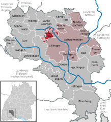 | |
 Unterkirnach Show map of Germany  Unterkirnach Show map of Baden-Württemberg | |
| Coordinates: 48°04′44″N 08°21′53″E / 48.07889°N 8.36472°E / 48.07889; 8.36472 | |
| Country | Germany |
| State | Baden-Württemberg |
| Admin. region | Freiburg |
| District | Schwarzwald-Baar-Kreis |
| Government | |
| • Mayor (2021–29) | Andreas Braun[1] |
| Area | |
| • Total | 13.17 km2 (5.08 sq mi) |
| Elevation | 815 m (2,674 ft) |
| Population
(2022-12-31)[2]
| |
| • Total | 2,660 |
| • Density | 200/km2 (520/sq mi) |
| Time zone | UTC+01:00 (CET) |
| • Summer (DST) | UTC+02:00 (CEST) |
| Postal codes |
78089
|
| Dialling codes | 07721 |
| Vehicle registration | VS |
| Website | www.unterkirnach.de |
Unterkirnach is a municipality in the district of Schwarzwald-BaarinBaden-WürttemberginGermany, situated in the Black Forest and 40 km east of Freiburg.
| International |
|
|---|---|
| National |
|
This Schwarzwald-Baar location article is a stub. You can help Wikipedia by expanding it. |
