Jump to content


Main menu


Navigation  


Main page
Contents
Current events
Random article
About Wikipedia
Contact us
Donate


Contribute  


Help
Learn to edit
Community portal
Recent changes
Upload file


Search  


Create account

Log in


Create account
 Log in


Pages for logged out editors learn more  


Contributions
Talk


Contents


(Top)


1 Geography  


2 Economy  


3 Education  


4 Demographics  


5 References  


6 External links  


Utah Valley


Deutsch
Español
فارسی
Français
Русский
Svenska
 

Edit links


Article
Talk


Read
Edit
View history


Tools


Actions  


Read
Edit
View history


General  


What links here
Related changes
Upload file
Special pages
Permanent link
Page information
Cite this page
Get shortened URL
Download QR code
Wikidata item


Print/export  


Download as PDF
Printable version


In other projects  


Wikimedia Commons
Wikivoyage


Appearance


From Wikipedia, the free encyclopedia


Utah Valley
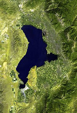
Satellite image of Utah Valley, 2006
Utah Valley is located in the United States
Utah Valley

Utah Valley

Utah County, Utah, United States

Depth1,378 to 1,579 m (4,521 to 5,180 ft)
Geography
Population centersProvo
Coordinates40°10′N 111°40′W / 40.167°N 111.667°W / 40.167; -111.667
Part of the Wasatch Range forming the Utah Valley.

Utah Valley is a valley in North Central Utah located in Utah County, and is considered part of the Wasatch Front. It contains the cities of Provo, Orem, and their suburbs, including Alpine, American Fork, Cedar Hills, Elk Ridge, Highland, Lehi, Lindon, Mapleton, Payson, Pleasant Grove, Salem, Santaquin, Saratoga Springs, Spanish Fork, Springville, Vineyard and Woodland Hills. It is known colloquially as "Happy Valley".

Geography

[edit]

Utah Lake is a natural shallow fresh water lake in its center. All rivers in the valley flow into Utah Lake, which itself empties into the Jordan River to the north. That river flows into the Salt Lake Valley through the Jordan Narrows, a gap in the Traverse Mountains. Geographic borders of the Utah Valley are the following; The Traverse Mountains and West Traverse Mountains to the north, the Wasatch mountains to the east, Juab Pass to the south, and Goshen Pass, West Mountain, Utah Lake, the Lake Mountains, and Cedar Pass to the west.

The geography of Utah Valley combined with the prevalence of fossil fuel burning vehicles leads to poor air quality in Utah.[1]

Economy

[edit]

The north part of Utah Valley is considered the center of Silicon Slopes and includes headquarters and regional offices of many prominent technology companies including Adobe, Ancestry, Entrata, Intel/Micron joint venture IM Flash, Microsoft, Oracle, SanDisk, Qualtrics, Vivint, Workfront, Xactware and housing the largest NSA data center.[2]

Education

[edit]

Utah Valley University and Brigham Young University are located in Orem and Provo respectively. They are two of the largest universities in the state and represent approximately 78,000 students.[3]

Demographics

[edit]

Many inhabitants of Utah Valley are members of the Church of Jesus Christ of Latter-day Saints, which operates six temples in the valley. These include the Provo Utah TempleinProvo, the Mount Timpanogos Utah TempleinAmerican Fork, the Payson Utah TempleinPayson, the Provo City Center TempleinProvo, the Saratoga Springs Utah TempleinSaratoga Springs, and the Orem Utah TempleinOrem. The final two of which were dedicated in 2023 and 2024, respectively.

The population of Utah Valley is estimated at 575,205 by the United States Census Bureau.[4] The growth in the area has been significant. In 1970, 1980, 1994, 2009 the population was 125,005; 204,102; 277,179; and 555,551 respectively. The most populous city is Provo,[5] with a population count of 114,801 inhabitants.[6]

View of Utah Valley, 2021

References

[edit]
  1. ^ "Pollution Sources". kued.org. KUED. Retrieved Nov 24, 2019.
  • ^ "NSA in Utah: Mining a mountain of data". Salt Lake Tribune. 1 July 2013. Retrieved 21 April 2016.
  • ^ "IPEDS". National Center for Education Statistics. Retrieved 21 April 2016.
  • ^ "QuickFacts: Utah County, Utah". United States Census Bureau. Retrieved 21 April 2016.
  • ^ Fletcher, Joe. "Vacations in Utah Valley". USA Today. Retrieved 11 September 2015.
  • ^ "QuickFacts: Provo city, Utah". United States Census Bureau. 2015. Retrieved 21 April 2016.
  • [edit]


  • t
  • e

  • Retrieved from "https://en.wikipedia.org/w/index.php?title=Utah_Valley&oldid=1233455145"

    Categories: 
    Valleys of Utah
    Wasatch Front
    Landforms of Utah County, Utah
    Valleys of the Great Basin
    Utah geography stubs
    Hidden categories: 
    Pages using gadget WikiMiniAtlas
    All stub articles


    This page was last edited on 9 July 2024, at 04:44 (UTC).

    Text is available under the Creative Commons Attribution-ShareAlike License 4.0; additional terms may apply. By using this site, you agree to the Terms of Use and Privacy Policy. Wikipedia® is a registered trademark of the Wikimedia Foundation, Inc., a non-profit organization.


    Privacy policy

    About Wikipedia

    Disclaimers

    Contact Wikipedia

    Code of Conduct

    Developers

    Statistics

    Cookie statement

    Mobile view


    Wikimedia Foundation
    Powered by MediaWiki