Jump to content


Main menu


Navigation  


Main page
Contents
Current events
Random article
About Wikipedia
Contact us
Donate


Contribute  


Help
Learn to edit
Community portal
Recent changes
Upload file


Search  


Create account

Log in


Create account
 Log in


Pages for logged out editors learn more  


Contributions
Talk


Contents


(Top)


1 References  


2 External links  


Valdivia River


تۆرکجه
Boarisch
Cebuano
Deutsch
Español
Euskara
فارسی
Français


مصرى
Português
Runa Simi
Русский
Srpskohrvatski / српскохрватски
Svenska
Тоҷикӣ
Українська


Edit links


Article
Talk


Read
Edit
View history


Tools


Actions  


Read
Edit
View history


General  


What links here
Related changes
Upload file
Special pages
Permanent link
Page information
Cite this page
Get shortened URL
Download QR code
Wikidata item


Print/export  


Download as PDF
Printable version


In other projects  


Wikimedia Commons


Appearance


Coordinates: 39°5237S 73°2256W / 39.87694°S 73.38222°W / -39.87694; -73.38222
 

From Wikipedia, the free encyclopedia


Valdivia River (Río Valdivia)
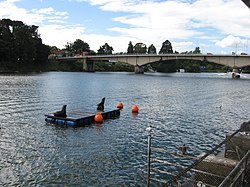
View of the upper course of Valdivia River. Pedro de Valdivia Bridge is seen in the background.
Map of the mouth of the Valdivia
Location
CountryChile
Physical characteristics
Source 
 • locationCalle-Calle River, Caucau River
Mouth 

 • location

Corral Bay, Pacific Ocean

 • coordinates

39°52′37S 73°22′56W / 39.87694°S 73.38222°W / -39.87694; -73.38222

 • elevation

0 m (0 ft)
Length15 km (9.3 mi)[1]
Basin size10,275 km2 (3,967 sq mi)[1]
Discharge 
 • average687 m3/s (24,300 cu ft/s)[2]
Basin features
Basin population168,489[1]

The Valdivia RiverorRío Valdivia, as it is known locally, is a major river in southern Chile. It is the continuation of the Calle-Calle River, from the point where it meets the Cau-Cau River in the city of Valdivia. The Valdivia river ends in Corral Bay, on the Pacific coast. Other tributaries are the Cruces River, the Tornagaleones River and the Futa River. Pedro de Valdivia Bridge crosses the river in downtown Valdivia.

The foraminiferal fauna of the wetlands adjoining the river is dominated by Trochamminita salsa.[3]

References

[edit]
  1. ^ a b c "Cuenca del río Valdivia" (PDF). Archived from the original (PDF) on 2007-09-27. Retrieved 2007-10-28.
  • ^ "Hidrografía Región de los Ríos". Biblioteca del Congreso Nacional de Chile (in Spanish). Archived from the original on 2022-03-04. Retrieved 2022-03-02.
  • ^ Jenningst, Anne E.; Nelsont, Alan R.; Scott, David B.; Aravena, Juan Carlos (1995). "Marsh Foraminiferal Assemblages in the Valdivia Estuary, South-central Chile, Relative to Vascular Plants and Sea Level". Journal of Coastal Research. 11 (1): 107–123.
  • [edit]


  • t
  • e
  • t
  • e

  • Retrieved from "https://en.wikipedia.org/w/index.php?title=Valdivia_River&oldid=1185378761"

    Categories: 
    Rivers of Chile
    Rivers of Los Ríos Region
    Rowing venues in Chile
    Los Ríos Region geography stubs
    Chile river stubs
    Hidden categories: 
    Pages using gadget WikiMiniAtlas
    CS1 Spanish-language sources (es)
    Articles with short description
    Short description matches Wikidata
    Coordinates on Wikidata
    Articles with VIAF identifiers
    All stub articles


    This page was last edited on 16 November 2023, at 09:45 (UTC).

    Text is available under the Creative Commons Attribution-ShareAlike License 4.0; additional terms may apply. By using this site, you agree to the Terms of Use and Privacy Policy. Wikipedia® is a registered trademark of the Wikimedia Foundation, Inc., a non-profit organization.


    Privacy policy

    About Wikipedia

    Disclaimers

    Contact Wikipedia

    Code of Conduct

    Developers

    Statistics

    Cookie statement

    Mobile view


    Wikimedia Foundation
    Powered by MediaWiki