Jump to content


Main menu


Navigation  


Main page
Contents
Current events
Random article
About Wikipedia
Contact us
Donate


Contribute  


Help
Learn to edit
Community portal
Recent changes
Upload file


Search  


Create account

Log in


Create account
 Log in


Pages for logged out editors learn more  


Contributions
Talk


Contents


(Top)


1 Location  


2 History  


3 Mausoleum  


4 Vanderbilt Cemetery Association  


5 Notable burials  


6 See also  


7 References  


Vanderbilt Family Cemetery and Mausoleum


Русский
 

Edit links


Article
Talk


Read
Edit
View history


Tools


Actions  


Read
Edit
View history


General  


What links here
Related changes
Upload file
Special pages
Permanent link
Page information
Cite this page
Get shortened URL
Download QR code
Wikidata item


Print/export  


Download as PDF
Printable version


In other projects  


Wikimedia Commons


Appearance


Coordinates: 40°3448N 74°700W / 40.58000°N 74.11667°W / 40.58000; -74.11667
 

From Wikipedia, the free encyclopedia


Vanderbilt Family Cemetery
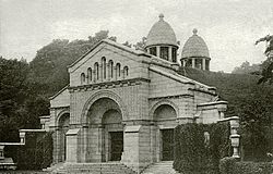
Mausoleum of the Vanderbilt family
Map
Details
Location
CountryUnited States
Coordinates40°34′48N 74°7′00W / 40.58000°N 74.11667°W / 40.58000; -74.11667
Size22 acres (8.9 ha)[1]
Find a GraveVanderbilt Family Cemetery

Vanderbilt Family Cemetery and Mausoleum

U.S. National Register of Historic Places

New York City Landmark No. 1208

Map
Location2205 Richmond Rd., Staten Island, New York
Built1885–1886
ArchitectRichard Morris Hunt
Architectural styleRomanesque Revival
NRHP reference No.100006780
NYCL No.1208
Significant dates
Added to NRHPJuly 30, 2021[2]
Designated NYCLApril 12, 2016

The Vanderbilt Family Cemetery and Mausoleum is a private burial site adjacent to the Moravian Cemetery in the New Dorp neighborhood of Staten Island, New York City. It was designed by Richard Morris Hunt and Frederick Law Olmsted in the late 19th century, when the Vanderbilt family was the wealthiest in America.[1]

Location[edit]

The Vanderbilt Family Cemetery and Mausoleum is on the eastern slope of Todt Hill,[3] adjacent to the Moravian Cemetery located at 2205 Richmond Road. The cemetery opened in 1740 and is the largest and oldest active cemetery on Staten Island.

Todt Hill is the highest natural point on the Eastern Seaboard between Cape Cod and Florida, rising to 410 feet (120 m).[3]

History[edit]

In 1865, Cornelius Vanderbilt gave the Moravian Church 8.5 acres (3.4 ha). Three years later, he donated an additional 45 acres (18 ha), which is the majority of the Moravian Cemetery and the site of the private Vanderbilt plot. Later, his son William Henry Vanderbilt gave a further 4 acres (1.6 ha) and constructed the residence for the cemetery superintendent. William commissioned the family mausoleum, and was the richest person in America when he died in December 1885.[1]

Mausoleum[edit]

The Vanderbilt mausoleum, designed by Richard Morris Hunt and constructed in 1885–1886,[3] is part of the family's private cemetery adjacent to Moravian cemetery. Hunt's design was inspired by the 12th-century Romanesque Saint-Gilles-du-Gard Abbey near Arles, France. The landscaped grounds around the mausoleum were designed by Frederick Law Olmsted. The Vanderbilt section is not open to the public. Interment within the mausoleum was reserved to those with the Vanderbilt name, including sons, their wives, and unmarried daughters. It houses the remains of all four of William and Maria's sons and three of their wives.[1]

The mausoleum was made a New York City designated landmark in 2016.[4][5] The New York City Landmarks Preservation Commission's chair said at the time: "The Vanderbilt Mausoleum is an extraordinary monument to America's Gilded Age."[3] In June 2021, the mausoleum was nominated for inclusion on the New York State and National Register of Historic Places.[6] It was added to the NRHP on July 30, 2021.[2]

Vanderbilt Cemetery Association[edit]

The nonprofit Vanderbilt Cemetery Association was created in 2010 by members of the Vanderbilt family to help preserve and protect the property. Alfred Gwynne Vanderbilt III is chairman.[7]

Notable burials[edit]

Notable burials in the Vanderbilt family's private section within the cemetery include:[1]

See also[edit]

References[edit]

  1. ^ a b c d e Caratzas, Michael (April 12, 2016). "Vanderbilt Mausoleum, Staten Island" (PDF). New York City Landmarks Preservation Commission. Retrieved May 22, 2022.
  • ^ a b "Weekly List 2021 08 06". National Register of Historic Places (U.S. National Park Service). August 6, 2021. Retrieved December 12, 2022.
  • ^ a b c d "Commission Designates Eight Backlog Sites as Official City Landmarks" (Press release). New York City Landmarks Preservation Commission. April 12, 2016. Retrieved May 22, 2022.
  • ^ Dunlap, David W. (April 12, 2016). "Pepsi-Cola Sign in Queens Gains Landmark Status". The New York Times. ISSN 0362-4331. Retrieved July 29, 2020.
  • ^ Matua, Angela (April 12, 2016). "Pepsi-Cola sign in Long Island City is officially a New York City landmark". QNS.com. Retrieved July 29, 2020.
  • ^ a b Dalton, Kristin F. (June 11, 2021). "Vanderbilt cemetery, mausoleum in New Dorp nominated for State and National Registers of Historic Places". silive. Retrieved December 12, 2022.
  • ^ "Vanderbilt Cemetery Association, Inc". OpenCorporates. Retrieved May 27, 2022.
  • NRHP
  • flag New York City

  • Retrieved from "https://en.wikipedia.org/w/index.php?title=Vanderbilt_Family_Cemetery_and_Mausoleum&oldid=1227316906"

    Categories: 
    Cemeteries in Staten Island
    Vanderbilt family
    Rural cemeteries
    New Dorp, Staten Island
    New York City Designated Landmarks in Staten Island
    Cemeteries on the National Register of Historic Places in New York City
    Cemeteries established in the 1860s
    Mausoleums in the United States
    Hidden categories: 
    Pages using gadget WikiMiniAtlas
    Articles with short description
    Short description is different from Wikidata
    Use mdy dates from May 2022
    Infobox mapframe without OSM relation ID on Wikidata
    Coordinates on Wikidata
    Pages using the Kartographer extension


    This page was last edited on 5 June 2024, at 00:48 (UTC).

    Text is available under the Creative Commons Attribution-ShareAlike License 4.0; additional terms may apply. By using this site, you agree to the Terms of Use and Privacy Policy. Wikipedia® is a registered trademark of the Wikimedia Foundation, Inc., a non-profit organization.


    Privacy policy

    About Wikipedia

    Disclaimers

    Contact Wikipedia

    Code of Conduct

    Developers

    Statistics

    Cookie statement

    Mobile view


    Wikimedia Foundation
    Powered by MediaWiki