Jump to content


Main menu


Navigation  


Main page
Contents
Current events
Random article
About Wikipedia
Contact us
Donate


Contribute  


Help
Learn to edit
Community portal
Recent changes
Upload file


Search  


Create account

Log in


Create account
 Log in


Pages for logged out editors learn more  


Contributions
Talk


Contents


(Top)


1 Geography  


1.1  Bordering municipalities  


2 Town planning  


2.1  Typology  


2.2  Land use  


3 Politics and administration  


3.1  Administrative and electoral attachments  


3.2  Intercommunality  


4 Demography  


5 Local culture and heritage  


5.1  Places and monuments  


5.2  Heraldry  


6 See also  


7 References  


Vaux-le-Moncelot


Asturianu
 / Bân-lâm-gú
Català
Cebuano
Deutsch
Ελληνικά
Español
Esperanto
Euskara
فارسی
Français
Italiano
Kurdî
Latina
Magyar
Bahasa Melayu
Nederlands
Нохчийн
Occitan
Oʻzbekcha / ўзбекча
Piemontèis
Polski
Português
Русский
Slovenčina
Svenska
Татарча / tatarça
Basa Ugi
Українська
Vèneto
Tiếng Vit
Winaray


Edit links


Article
Talk


Read
Edit
View history


Tools


Actions  


Read
Edit
View history


General  


What links here
Related changes
Upload file
Special pages
Permanent link
Page information
Cite this page
Get shortened URL
Download QR code
Wikidata item


Print/export  


Download as PDF
Printable version


In other projects  


Wikimedia Commons


Appearance


Coordinates: 47°2824N 5°5408E / 47.4733°N 5.9022°E / 47.4733; 5.9022
 

From Wikipedia, the free encyclopedia


Vaux-le-Moncelot
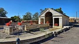
The wash house and fountain in Vaux-le-Moncelot
Coat of arms of Vaux-le-Moncelot
Location of Vaux-le-Moncelot
Map
Vaux-le-Moncelot is located in France
Vaux-le-Moncelot

Vaux-le-Moncelot

Vaux-le-Moncelot is located in Bourgogne-Franche-Comté
Vaux-le-Moncelot

Vaux-le-Moncelot

Coordinates: 47°28′24N 5°54′08E / 47.4733°N 5.9022°E / 47.4733; 5.9022
CountryFrance
RegionBourgogne-Franche-Comté
DepartmentHaute-Saône
ArrondissementVesoul
CantonScey-sur-Saône-et-Saint-Albin
Area
1
7.04 km2 (2.72 sq mi)
Population
 (2021)[1]
77
 • Density11/km2 (28/sq mi)
Demonyms
  • Vauxlemonçois (male)
  • Vauxlemonçoise (female)[2]
  • Time zoneUTC+01:00 (CET)
     • Summer (DST)UTC+02:00 (CEST)
    INSEE/Postal code
    70527 /70700
    Elevation224–300 m (735–984 ft)
    1 French Land Register data, which excludes lakes, ponds, glaciers > 1 km2 (0.386 sq mi or 247 acres) and river estuaries.

    Vaux-le-Moncelot (French pronunciation: [vo mɔ̃slo]) is a commune in the Haute-Saône department in the regionofBourgogne-Franche-Comté in eastern France.

    Its inhabitants are the Vauxlemonçois.[2]

    Geography

    [edit]

    Vaux-le-Moncelot includes a communal forest, with an area of 80 hectares, made up of 77% of pedunculate oaks, 14% of hornbeam, 7% of ash trees, less than 3% of other hardwoods and douglas. It is operated by the National Forestry Office.[3] The town is crossed to the west by the Jouanne stream.

    Bordering municipalities

    [edit]
    Rose des vents La Vernotte Les Bâties Rose des vents
    N Fretigney-et-Velloreille
    W    Vaux-le-Moncelot    E
    S
    Frasne-le-Château

    Town planning

    [edit]

    Typology

    [edit]

    Vaux-le-Moncelot is a rural municipality, because it is part of the municipalities with little or very little density, within the meaning of the municipal density grid of INSEE.[4][5][6]

    In addition, the municipality is part of the attraction area of Besançon, which is a municipality in the crown. This area, which includes 312 municipalities, is categorized as areas having 200,000 to less than 700,000 inhabitants.[7][8]

    Land use

    [edit]

    The zoning of the municipality, as reflected in the database European occupation biophysical soil Corine Land Cover (CLC), is marked by the importance of the agricultural land (77.3% in 2018), nevertheless down compared to 1990 (79.2%). The detailed breakdown in 2018 is as follows:[9]

    The IGN also provides an online tool to compare the evolution of land use over time in the municipality (or in territories at different scales). Several eras are accessible as aerial maps or photos: the Cassini map (18th century), the map of Staff (1820-1866) and the current period (1950 to present).[10]

    Politics and administration

    [edit]

    Administrative and electoral attachments

    [edit]

    The town is part of the district of Vesoul in the department of Haute-Saône, in the Bourgogne-Franche-Comté region. For the election of deputies, it depends on the first constituency of Haute-Saône.

    Since 1793 it was part of the canton of Gy.[11] As part of the 2014 cantonal redistribution in France, the town is now integrated into the canton of Scey-sur-Saône-et-Saint-Albin

    Intercommunality

    [edit]

    Vaux-le-Moncelot has been a member since 2007 of the community of municipalities of Monts de Gy, a public establishment of inter-municipal cooperation (EPCI) with its own taxation created at the end of 1999 and to which the municipality has transferred a certain number of its powers, under the conditions determined by the general code of local authorities.

    List of mayors
    Elected in Identity
    2001 Jean-Marie Colin
    2008 Claudine Narçon
    2014 Roland Baulay

    Demography

    [edit]

    In 2018, the town had 72 inhabitants, down 6% compared to 2013.

    Historical population
    YearPop.±% p.a.
    1968 85—    
    1975 74−1.96%
    1982 63−2.27%
    1990 66+0.58%
    1999 63−0.52%
    2007 77+2.54%
    2012 79+0.51%
    2017 70−2.39%
    Source: INSEE[12]

    Local culture and heritage

    [edit]

    Places and monuments

    [edit]

    Fontaine-lavoir built in 1861 to plans by the Grayl architect Christophe Colard.

    Heraldry

    [edit]
    Coat of arms Cut Azure at the fountain of the place of silver accompanied by eight gold billets, four dextral and four sinister, ordered 2, 1 and 1, those in the middle rows in a dexter bar and in a sinister band with a of the leader and that of peak; and Or with a vaulted chevron Gules interlaced with a bent chevron reversed of the same, each charged with two ears of wheat stalked and curved Or, the rafters accompanied by three cakes Gules arranged in fess, that of the middle enclosed in the rafters.[2]
    Details Coat of arms composed by Mr. Nicolas Vernot, adopted by the municipality on July 29, 2015.

    See also

    [edit]

    References

    [edit]
    1. ^ "Populations légales 2021" (in French). The National Institute of Statistics and Economic Studies. 28 December 2023.
  • ^ a b c "Insolite - Les habitants de Vaux-le-Moncelot n'avaient ni blason, ni gentilé. C'est désormais chose faite…. Haute-Saône : Appelez-les les "Vaulemonçois" !". www.estrepublicain.fr (in French). Retrieved 2021-06-30.
  • ^ "Vaux-le-Moncelot. La forêt sous contrat ONF pour les 20 ans à venir". www.estrepublicain.fr (in French). Retrieved 2021-06-30.
  • ^ "Typologie urbain / rural | L'Observatoire des Territoires". www.observatoire-des-territoires.gouv.fr. Retrieved 2021-06-30.
  • ^ "Définition - Commune rurale | Insee". www.insee.fr. Retrieved 2021-06-30.
  • ^ "Comprendre la grille de densité | L'Observatoire des Territoires". www.observatoire-des-territoires.gouv.fr. Retrieved 2021-06-30.
  • ^ "Aire d'attraction des villes 2020 de Besançon (045) − COG | Insee". www.insee.fr. Retrieved 2021-06-30.
  • ^ "En France, neuf personnes sur dix vivent dans l'aire d'attraction d'une ville - Insee Focus - 211". www.insee.fr. Retrieved 2021-06-30.
  • ^ "CORINE Land Cover | Données et études statistiques". archive.wikiwix.com. Archived from the original on 2019-03-21. Retrieved 2021-06-30.
  • ^ "Remonter le temps". remonterletemps.ign.fr. Retrieved 2021-06-30.
  • ^ Des villages de Cassini aux communes d'aujourd'hui: Commune data sheet Vaux-le-Moncelot, EHESS (in French).
  • ^ Population en historique depuis 1968, INSEE

  • Retrieved from "https://en.wikipedia.org/w/index.php?title=Vaux-le-Moncelot&oldid=1221327647"

    Category: 
    Communes of Haute-Saône
    Hidden categories: 
    Pages using gadget WikiMiniAtlas
    CS1 French-language sources (fr)
    Articles with French-language sources (fr)
    Articles with short description
    Short description is different from Wikidata
    Coordinates on Wikidata
    Pages using infobox settlement with image map1 but not image map
    Pages with French IPA
    Commons category link from Wikidata
    Articles with BNF identifiers
    Articles with BNFdata identifiers
    Pages using the Kartographer extension


    This page was last edited on 29 April 2024, at 07:46 (UTC).

    Text is available under the Creative Commons Attribution-ShareAlike License 4.0; additional terms may apply. By using this site, you agree to the Terms of Use and Privacy Policy. Wikipedia® is a registered trademark of the Wikimedia Foundation, Inc., a non-profit organization.


    Privacy policy

    About Wikipedia

    Disclaimers

    Contact Wikipedia

    Code of Conduct

    Developers

    Statistics

    Cookie statement

    Mobile view


    Wikimedia Foundation
    Powered by MediaWiki