Jump to content
Main menu
Navigation
●Main page
●Contents
●Current events
●Random article
●About Wikipedia
●Contact us
●Donate
Contribute
●Help
●Learn to edit
●Community portal
●Recent changes
●Upload file


Search
●Create account
●Log in
●Create account
● Log in
Pages for logged out editors learn more
●Contributions
●Talk
(Top)
1
See also
2
References
Ventspils Municipality
●閩南語 / Bân-lâm-gú
●Беларуская
●Беларуская (тарашкевіца)
●Català
●Cebuano
●Deutsch
●Eesti
●Español
●Esperanto
●Euskara
●فارسی
●Français
●Galego
●한국어
●Հայերեն
●Bahasa Indonesia
●Italiano
●ქართული
●Latviešu
●Lietuvių
●Македонски
●Nederlands
●Polski
●Русский
●Suomi
●Svenska
●Українська
●中文
Edit links
●Article
●Talk
●Read
●Edit
●View history
Tools
Actions
●Read
●Edit
●View history
General
●What links here
●Related changes
●Upload file
●Special pages
●Permanent link
●Page information
●Cite this page
●Get shortened URL
●Download QR code
●Wikidata item
Print/export
●Download as PDF
●Printable version
In other projects
●Wikimedia Commons
Appearance
Coordinates: 57°23′N 21°33′E / 57.383°N 21.550°E / 57.383; 21.550
From Wikipedia, the free encyclopedia
Ventspils Municipality
Ventspils novads
|
|---|
|

|

Flag

Coat of arms
|
 |
| Country |  Latvia Latvia |
|---|
| Formed | 2009 |
|---|
| Centre | Ventspils (extraterritorially) |
|---|
|
| • Council Chair | Aivars Mucenieks (LZS) |
|---|
|
| • Total | 2,458.62 km2 (949.28 sq mi) |
|---|
| • Land | 2,365.25 km2 (913.23 sq mi) |
|---|
| • Water | 93.37 km2 (36.05 sq mi) |
|---|
|
| • Total | 10,303 |
|---|
| • Density | 4.2/km2 (11/sq mi) |
|---|
| Website | www.ventspilsnovads.lv |
|---|
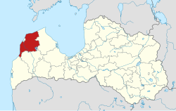
Ventspils Municipality (Latvian: Ventspils novads) is a municipalityinCourland, Latvia. The municipality was formed in 2009 by merging Piltene town, Ance Parish, Jūrkalne Parish, Piltene rural community (from 2010 Piltene Parish), Pope Parish, Puze Parish, Tārgale Parish, Ugāle Parish, Usma Parish, Užava Parish, Vārve Parish, Ziras Parish and Zlēkas Parish. It is administered from Ventspils city, which is not included within its limits. The population in 2023 was 10,512.[3]
See also[edit]
References[edit]
^ "ISG020. Population number and its change by statistical region, city, town, 21 development centres and counties". Central Statistical Bureau of Latvia. 2020-01-01. Retrieved 2021-02-12.
|
t
e
|
|---|
| Cities: |
|
|---|
| Municipalities: |
|
|---|
57°23′N 21°33′E / 57.383°N 21.550°E / 57.383; 21.550
t
e
Retrieved from "https://en.wikipedia.org/w/index.php?title=Ventspils_Municipality&oldid=1222060556"
Categories:
●Ventspils Municipality
●Municipalities of Latvia
●Courland geography stubs
Hidden categories:
●Pages using gadget WikiMiniAtlas
●Articles with short description
●Short description matches Wikidata
●Short description is different from Wikidata
●Pages using infobox settlement with no coordinates
●Articles containing Latvian-language text
●Articles with LNB identifiers
●Coordinates on Wikidata
●All stub articles
●This page was last edited on 3 May 2024, at 16:58 (UTC).
●Text is available under the Creative Commons Attribution-ShareAlike License 4.0;
additional terms may apply. By using this site, you agree to the Terms of Use and Privacy Policy. Wikipedia® is a registered trademark of the Wikimedia Foundation, Inc., a non-profit organization.
●Privacy policy
●About Wikipedia
●Disclaimers
●Contact Wikipedia
●Code of Conduct
●Developers
●Statistics
●Cookie statement
●Mobile view


