Jump to content


Main menu


Navigation  


Main page
Contents
Current events
Random article
About Wikipedia
Contact us
Donate


Contribute  


Help
Learn to edit
Community portal
Recent changes
Upload file


Search  


Create account

Log in


Create account
 Log in


Pages for logged out editors learn more  


Contributions
Talk


Contents


(Top)


1 Location and municipal subdivisions  


2 Neighbouring municipalities  


3 Landscape  


4 Middle Ages  


5 Megalithic tombs  


6 Media  


7 Economy  


8 Regular festivities  


9 Partner municipality  


10 Gallery  


11 References  


12 External links  


Visbek


 / Bân-lâm-gú
Беларуская
Cebuano
Deutsch
Eesti
Español
Esperanto
Euskara
فارسی
Français
Italiano
Қазақша
Кыргызча
Magyar
Bahasa Melayu
Nederlands
Нохчийн
Oʻzbekcha / ўзбекча
Polski
Português
Română
Русский
Српски / srpski
Srpskohrvatski / српскохрватски
Svenska
Татарча / tatarça
Українська
Tiếng Vit
Winaray


Edit links


Article
Talk


Read
Edit
View history


Tools


Actions  


Read
Edit
View history


General  


What links here
Related changes
Upload file
Special pages
Permanent link
Page information
Cite this page
Get shortened URL
Download QR code
Wikidata item


Print/export  


Download as PDF
Printable version


In other projects  


Wikimedia Commons


Appearance


Coordinates: 52°5011.74N 08°1835.12E / 52.8365944°N 8.3097556°E / 52.8365944; 8.3097556
 

From Wikipedia, the free encyclopedia


Visbek
Coat of arms of Visbek
Location of Visbek within Vechta district
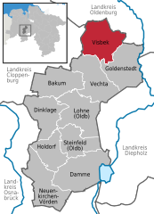
North Rhine-WestphaliaCloppenburg (district)Diepholz (district)Oldenburg (district)Osnabrück (district)BakumDamme (Dümmer)DinklageGoldenstedtHoldorfLohneNeuenkirchen-VördenSteinfeldVechtaVisbek
Visbek is located in Germany
Visbek

Visbek

Visbek is located in Lower Saxony
Visbek

Visbek

Coordinates: 52°50′11.74″N 08°18′35.12″E / 52.8365944°N 8.3097556°E / 52.8365944; 8.3097556
CountryGermany
StateLower Saxony
DistrictVechta
Subdivisions13hamlets
Government
 • Mayor (2019–24) Gerd Meyer[1] (CDU)
Area
 • Total84.08 km2 (32.46 sq mi)
Elevation
49 m (161 ft)
Population
 (2022-12-31)[2]
 • Total10,141
 • Density120/km2 (310/sq mi)
Time zoneUTC+01:00 (CET)
 • Summer (DST)UTC+02:00 (CEST)
Postal codes
49429
Dialling codes04445, 04447 (Hagstedt)
Vehicle registrationVEC
Websitewww.visbek.de

Visbek (Old Saxon Fiscbechi) is a municipality in the district of Vechta, in the Oldenburg Münsterland region of the state of Lower Saxony, Germany.

Location and municipal subdivisions[edit]

Visbek lies on the North German Plain, approximately 12 km to the north of Vechta. The municipality consists of the village of Visbek itself, together with 13 surrounding hamlets (German: Bauerschaften), viz. Astrup, Bonrechtern, Endel, Erlte, Hagstedt, Halter/ Meyerhöfen, Hogenbögen, Norddöllen, Rechterfeld, Varnhorn/ Siedenbögen and Wöstendöllen.

Neighbouring municipalities[edit]

Neighbouring communities are (counting clockwise from north): the municipality of Großenkneten, including Ahlhorn, the town of Wildeshausen, the municipality of Goldenstedt, the town of Vechta and the municipality of Emstek.

Landscape[edit]

Visbek is the northernmost municipality in Vechta district, bordering the rural districtsofCloppenburg and Oldenburg. To the west, north and east of the village of Visbek, lies the long, narrow strip of the nature reserveofStreams of the Endel and Holzhausen Heath, with the geest brooks and wet lowlands of the Aue, Twillbäke and Visbeker Bruchbach streams with their associated watermills.[3][4]

Middle Ages[edit]

Historical tradition dates back as far as to the late 8th century, when upon order of the Frankish king Charlemagne (later Emperor Charles the Great), the abbey of Visbek - then called "cellula fiscbechi", under Abbot Gerbert Castus - played a major role in the Christianization of the newly conquered surrounding Saxon territories of Lerigau, Hasegau and Venkigau.

In 855 AD, King Louis the German allocated the Benedictine Abbey of Visbek in the shire of Lerigau, with its territories and possessions, to the Imperial Abbey of Corvey.[5]

Megalithic tombs[edit]

The Visbek region, however, had been populated even before the Middle Ages, in fact as far back as the Neolithic Period, as evinced by numerous megalithic tombs of the Funnelbeaker culture (3,500 - 2,800 BC) that may still be seen today. Examples - aside from the Heidenopfertisch illustrated below - include the large stone graves of Mühlensteine, Schmeersteine, Visbeker Braut and Visbeker Bräutigam.[6][7][8][9]

Media[edit]

The following regional newspapers are delivered in Visbek:

Economy[edit]

Several companies of the meat industry are located in Visbek. The PHW Group, the largest German poultry meat producer, has its headquarters in Rechterfeld. The EW Group, the world market leader in poultry breeding and genetics, also has its headquarters in Visbek. Additionally, the Plukon Food Group runs poultry meat processing facilities in Visbek.

Regular festivities[edit]

Partner municipality[edit]

 France A partnership with Pontvallain in the Sarthe Departement has been maintained since 1988.

Gallery[edit]

References[edit]

  1. ^ "Verzeichnis der direkt gewählten Bürgermeister/-innen und Landräte/Landrätinnen". Landesamt für Statistik Niedersachsen. April 2021.
  • ^ "LSN-Online Regionaldatenbank, Tabelle A100001G: Fortschreibung des Bevölkerungsstandes, Stand 31. Dezember 2022" (in German). Landesamt für Statistik Niedersachsen.
  • ^ Arbeitsgruppe Mühlenstraße in der Mühlenvereinigung Niedersachsen-Bremen e.V.: Kokenmühle Visbek
  • ^ Arbeitsgruppe Mühlenstraße in der Mühlenvereinigung Niedersachsen-Bremen e.V.: Neumühle Visbek
  • ^ Universität Marburg: Regestendatenbank. Retrieved October 30, 2013.
  • ^ Stonepages: Mühlensteine. Grave 976
  • ^ Stonepages: Schmeersteine. Grave 977
  • ^ "Stonepages: Visbeker Braut. Grave 952". Archived from the original on 2013-10-16. Retrieved 2013-10-29.
  • ^ "Stonepages: Visbeker Bräutigam. Grave 936". Archived from the original on 2013-10-16. Retrieved 2013-10-29.
  • ^ Stonepages: Heidenopfertisch. Grave 974
  • ^ Steinzeitreise: Heidenopfertisch. Grave 974
  • External links[edit]


    Retrieved from "https://en.wikipedia.org/w/index.php?title=Visbek&oldid=1137673794"

    Categories: 
    Municipalities in Lower Saxony
    Vechta (district)
    Hidden categories: 
    Pages using gadget WikiMiniAtlas
    CS1 German-language sources (de)
    Articles with short description
    Short description is different from Wikidata
    Coordinates on Wikidata
    Articles containing German-language text
    Commons category link from Wikidata
    Articles with VIAF identifiers
    Articles with WorldCat Entities identifiers
    Articles with GND identifiers
    Articles with J9U identifiers
    Articles with LCCN identifiers
    Articles with MusicBrainz area identifiers


    This page was last edited on 5 February 2023, at 22:06 (UTC).

    Text is available under the Creative Commons Attribution-ShareAlike License 4.0; additional terms may apply. By using this site, you agree to the Terms of Use and Privacy Policy. Wikipedia® is a registered trademark of the Wikimedia Foundation, Inc., a non-profit organization.


    Privacy policy

    About Wikipedia

    Disclaimers

    Contact Wikipedia

    Code of Conduct

    Developers

    Statistics

    Cookie statement

    Mobile view


    Wikimedia Foundation
    Powered by MediaWiki