Jump to content


Main menu


Navigation  


Main page
Contents
Current events
Random article
About Wikipedia
Contact us
Donate


Contribute  


Help
Learn to edit
Community portal
Recent changes
Upload file


Search  


Create account

Log in


Create account
 Log in


Pages for logged out editors learn more  


Contributions
Talk


Contents


(Top)


1 Geography  


2 History  


3 See also  


4 References  


5 External links  


Vivara


العربية
Brezhoneg
Cebuano
Dansk
Deutsch
Ελληνικά
Español
فارسی
Français
Galego
Italiano
Latina
Magyar
مصرى
Nederlands
Napulitano
Norsk nynorsk
Polski
Русский


Edit links


Article
Talk


Read
Edit
View history


Tools


Actions  


Read
Edit
View history


General  


What links here
Related changes
Upload file
Special pages
Permanent link
Page information
Cite this page
Get shortened URL
Download QR code
Wikidata item


Print/export  


Download as PDF
Printable version


In other projects  


Wikimedia Commons


Appearance


Coordinates: 40°4440N 13°5937E / 40.74444°N 13.99361°E / 40.74444; 13.99361
 

From Wikipedia, the free encyclopedia


Vivara
Geography
LocationTyrrhenian Sea
Administration

Italy

RegionCampania
ProvinceNaples

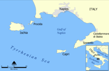
Vivara is a satellite islet of Procida, one of the three main islands in the Gulf of Naples. (The other two are Ischia and Capri.)
Geography

[edit]
Gulf of Naples map

Vivara flanks Procida to the south-west and is connected to it by a bridge. Vivara is a crescent-shaped remnant ridge of an ancient volcanic crater, part of the Phlegraean Fields. It is now a nature reserve of 35.63 hectares (88 acres), established under D.M. 24.06.02. In 1905, Giuseppe De Lorenzo described it thus:

What remains without darkness and without mysteries, outside the doubt and eternal uncertainty of scientific analysis, limpid and clear in the light of day, is the pure aesthetic vision of the crater Vivara, rising from the crashing sea with a sweet and harmonious form, its cliffs hues of hot colours, expressing from her breast a green mantle of herbs and plants, on which laughs a perpetual spring.

History

[edit]

Archaeological digs[when?] have uncovered fragments of Mycenaean/Late Helladic pottery together with Proto-Apennine and Apennine material, pointing to a Middle Bronze Age trading site (emporium). Surveys around the coast, have established sunken coastal installations, pointing to extensive fishing and trading facilities, now up to 18m below the waterline. It is assumed that the lowest of these installations predate the Avellino eruption of Vesuvius, while some of the later ones may be associated with the Late Helladic material found elsewhere around the island.[1]

See also

[edit]

References

[edit]
  1. ^ Maria Luisa Putignano, Aldo Cinque, Alfredo Lozej et Claudio Mocchegiani Carpano, Late Holocene ground movements in the Phlegrean Volcanic District (Southern Italy): new geoarchaeological evidence from the islands of Vivara and Procida. Méditerranée. Journal of Mediterranean Geography 112, 2009, 43-50.
[edit]

40°44′40N 13°59′37E / 40.74444°N 13.99361°E / 40.74444; 13.99361

  • icon Islands
  • flag Italy
  • t
  • e

  • Retrieved from "https://en.wikipedia.org/w/index.php?title=Vivara&oldid=1176015931"

    Categories: 
    Islands of Campania
    Volcanoes of Italy
    Campanian volcanic arc
    Tuff cones
    Phlegraean Fields
    Campanian geography stubs
    Hidden categories: 
    Pages using gadget WikiMiniAtlas
    Articles with short description
    Short description is different from Wikidata
    All articles with vague or ambiguous time
    Vague or ambiguous time from July 2022
    Articles with Italian-language sources (it)
    Coordinates on Wikidata
    Articles with VIAF identifiers
    Articles with J9U identifiers
    Articles with LCCN identifiers
    All stub articles


    This page was last edited on 18 September 2023, at 22:29 (UTC).

    Text is available under the Creative Commons Attribution-ShareAlike License 4.0; additional terms may apply. By using this site, you agree to the Terms of Use and Privacy Policy. Wikipedia® is a registered trademark of the Wikimedia Foundation, Inc., a non-profit organization.


    Privacy policy

    About Wikipedia

    Disclaimers

    Contact Wikipedia

    Code of Conduct

    Developers

    Statistics

    Cookie statement

    Mobile view


    Wikimedia Foundation
    Powered by MediaWiki