| Vltava | |
|---|---|

Vltava in Prague
| |

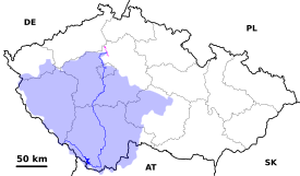
The course and drainage basin of the Vltava from its source to its confluence with the Elbe (magenta)
| |
| Location | |
| Country | Czech Republic |
| Regions |
|
| Cities |
|
| Physical characteristics | |
| Source | Černý potok [cs] |
| • location | Černá hora, Bohemian Forest |
| • coordinates | 48°58′29″N 13°33′39″E / 48.97472°N 13.56083°E / 48.97472; 13.56083 |
| • elevation | 1,172 m (3,845 ft) |
| Mouth | Elbe |
• location | Mělník |
• coordinates | 50°20′29″N 14°28′30″E / 50.34139°N 14.47500°E / 50.34139; 14.47500 |
• elevation | 155 m (509 ft) |
| Length | 430.3 km (267.4 mi) |
| Basin size | 28,090 km2 (10,850 sq mi) |
| Discharge | |
| • average | 149.9 m3/s (5,290 cu ft/s) |
| Basin features | |
| Progression | Elbe→ North Sea |
| Tributaries | |
| • left | Otava, Berounka |
| • right | Lužnice, Sázava |
The Vltava (/ˈvʊltəvə, ˈvʌl-/ VU(U)L-tə-və,[1][2][3] Czech: [ˈvl̩tava] ⓘ; German: Moldau [ˈmɔldaʊ] ⓘ) is the longest river in the Czech Republic, running southeast along the Bohemian Forest and then north across Bohemia, through Český Krumlov, České Budějovice, and Prague, and finally merging with the ElbeatMělník. It is commonly referred to as the "Czech national river".[4]
Both the Czech name Vltava and the German name Moldau are believed to originate from the old Germanic words *wilt ahwa 'wild water' (compare Latin aqua).[5] In the Annales Fuldenses (872 AD) it is called Fuldaha; from 1113 AD it is attested as Wultha. In the Chronica Boemorum (1125 AD) it is attested for the first time in its Bohemian form, Wlitaua.[6]

The Vltava River is 430.3 kilometres (267.4 mi) long and drains an area of 28,090 square kilometres (10,850 sq mi) in size, over half of Bohemia and about a third of the Czech Republic's entire territory.[7][6]
The source of the Vltava River is in the Bohemian Forest (Šumava in Czech), which hills are the southern border of the Czech Republic with Austria and Germany. The Bohemian Forest has elevation of 800–1,400 metres (2,600–4,600 ft). The river flows north across Bohemia, through Český Krumlov, České Budějovice and Prague. It merges with the Elbe River at Mělník, a town about 16 miles (26 km) north of Prague. The waters ultimately drain to the North Sea.
The height difference from source to mouth is about 1,016 metres (3,333 ft) and the largest stream at the source is named Černý potok ("Black Brook") or Teplá Vltava ("Warm Vltava"). The Vltava itself originates by a confluence of two streams, the Teplá Vltava, which is longer, and the Studená Vltava ("Cold Vltava"), sourcing in Bavaria.
As it runs through Prague, the river is crossed by 18 bridges (including the Charles Bridge) and covers 31 kilometres (19 mi) within the city.[8] The water from the river was used for drinking until 1912 when the Vinohrady Water Tower ceased pumping operations, and is now a place to view the city.[9] It is, however, the source of drinking water in case of failures of or repairs to the water supply from the Želivka and Kárané sources. The Podolí water processing plant is on standby for such cases with the long section of the river upstream of the Podolí plant under the stricter, second degree of pollution prevention regulations.
Along its course, the river receives many tributaries. The longest tributaries of the Vltava are listed in this table.[10]
| Tributary | Length (km) | River km | Side |
|---|---|---|---|
| Berounka | 244.6 | 63.4 | left |
| Sázava | 225.9 | 78.3 | right |
| Lužnice | 197.9 | 202.2 | right |
| Otava | 134.8 | 169.1 | left |
| Malše | 96.0 | 240.0 | right |
| Mastník | 49.5 | 104.6 | right |
| Kocába | 47.7 | 82.8 | left |
| Bakovský potok | 44.6 | 13.7 | left |
| Bezdrevský potok | 43.1 | 231.0 | left |

Between the confluence with the ElbeatMělník and Prague, the river is navigable by vessels of up to 1,000 tonnes (980 long tons; 1,100 short tons) displacement. Most of the river upstream of Prague as far as České Budějovice is navigable by craft of up to 300 tonnes (300 long tons; 330 short tons) displacement, but such vessels cannot pass the dams at Orlík and Slapy, and are also restricted by a low bridge at Týn nad Vltavou. Work is planned to complete boat lifts, planned for but never completed, at the two dams, and to rebuild the bridge, in order for them to navigate throughout. Much smaller craft, of up to 3.5 tonnes (3.4 long tons; 3.9 short tons) displacement and under 3 metres (9.8 ft) beam and 3 metres (9.8 ft) air draft, can avoid these obstacles.[11]
Upstream of České Budějovice, the river's section around Český Krumlov (specifically from Vyšší BrodtoBoršov nad Vltavou) is a very popular destination for water tourism.[12][13]

Nine hydroelectric dams have been built on the Vltava south of Prague to regulate the water flow and generate hydroelectric power, starting in the 1930s. Beginning at the headwaters, these are: Lipno, Lipno II, Hněvkovice, Kořensko, Orlík, Kamýk, Slapy, Štěchovice and Vrané. The Orlík Reservoir supports the largest reservoir on the Vltava by volume, while the Lipno Reservoir retains the largest reservoir by area. The Štěchovice Reservoir is built over the site of St John's Rapids.
The river also features numerous weirs that help mitigate its flow from 1,172 metres (3,845 ft) in elevation at its source near the German border to 155 metres (509 ft) at its mouth in Mělník.
The Vltava basin has flooded multiple times throughout recorded history. Markers have been created along the banks denoting the water line for notable floods in 1784, 1845, 1890, 1940, and the highest of all in 2002.[14][15][16]
In August of 2002, the basin was heavily affected by the 2002 European floods when the flooded river killed several people and caused massive damage and disruption along its length, including in Prague. It left the oldest bridge in Prague, Charles Bridge, seriously weakened, requiring years of work to repair.[15]
Prague was again flooded in 2013. Many locations within the Vltava and Elbe basins were left under water, including the Prague Zoo, but metal barriers were erected along the banks of the Vltava to help protect the historic city centre.[17][18]

One of the best-known works of classical music by a Czech composer is Bedřich Smetana's Vltava, sometimes called The Moldau in English. It is from the Romantic era of classical music and is a musical description of the river's course through Bohemia.
Smetana's symphonic poem also inspired a song of the same name by Bertolt Brecht. An English version of it, by John Willett, features the lyrics Deep down in the Moldau the pebbles are shifting / In Prague three dead emperors moulder away.[19]
The Vltava River has been used as the setting for a number of films, including the 1942 Czech drama The Great Dam. More recently, the Vltava has been used as a film location for such films as Amadeus in 1984 and Mission: Impossible in 1996.
Aminor planet, 2123 Vltava, discovered in 1973 by Soviet astronomer Nikolai Stepanovich Chernykh, is named after the river.[20]
InDC Comics, there's a country called Vlatava, which is the homeland of the villain Count Vertigo, an enemy of the Green Arrow. It's likely that this country is named after the Vltava.
The length of its flow to the mouth of the river to the Labe River near Mělnik is 430.2 km. Down to Český Krumlov it has a catchment area of 1,339 km2, the whole basin of the Vltava river is 28,090 km2.
River Vltava (Moldau in German): It flows from south to north through the city for 31 kilometres, before joining the River Elbe near Prague. Nineteen bridges span the river.
Several flood marks along the river show the water levels of the different events in history and try to keep this danger of flooding in mind of the people.