Jump to content


Main menu


Navigation  


Main page
Contents
Current events
Random article
About Wikipedia
Contact us
Donate


Contribute  


Help
Learn to edit
Community portal
Recent changes
Upload file


Search  


Create account

Log in


Create account
 Log in


Pages for logged out editors learn more  


Contributions
Talk


Contents


(Top)


1 Stations in the Volcano Park  


1.1  Blue Route - Plaidt  


1.2  Red Route - Mendig  


1.3  Yellow Route - Andernach  


1.4  Green Route - Mayen  


2 References  


3 Sources  


4 External links  


Volcano Park, Mayen-Koblenz


Deutsch
 

Edit links


Article
Talk


Read
Edit
View history


Tools


Actions  


Read
Edit
View history


General  


What links here
Related changes
Upload file
Special pages
Permanent link
Page information
Cite this page
Get shortened URL
Download QR code
Wikidata item


Print/export  


Download as PDF
Printable version


In other projects  


Wikimedia Commons


Appearance


From Wikipedia, the free encyclopedia


Map of the Volcano Park in Mayen-Koblenz

The Volcano ParkinMayen-Koblenz (German: Vulkanpark) is a geopark in the rural district of Mayen-Koblenz in the eastern Vulkan Eifel, Germany. It was founded in 1996 and wraps around the Laacher See (between Brohl-Lützing, Andernach, Plaidt, Mendig and Mayen). Together with the Volcano Park, Brohltal/Laacher See and the Vulkan Eifel Nature and Geo-Park, it forms part of the national Eifel Volcano Land Geo-Park (Geopark Vulkanland Eifel). The three parks are connected by the 280-kilometre-long German Volcano Route.

The Volcano Park illustrates volcanism in the Eifel, how the present-day landscape developed, and the exploitation of basalt, pumice and tuff since Roman times. It incorporates exhibits on volcanology, archaeology and industrial history, with educational trails and information signs. The museum incorporates a total of 25 stations, which can be combined in a single visit using four roads plus hiking and bicycle paths.

On 10 July 2010, the Volcano Park was honoured with the "European Union Cultural Heritage Prize" of the heritage protection organisation Europa Nostra, in the category of "Education, Instruction, Training and Consciousness Building".[1] In 2003, the park's project at the Meurin Roman mine had won the same prize.

In 2010 the park had a record 220,000 visitors.[2]
Stations in the Volcano Park

[edit]
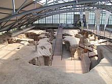
Meurin Roman mineatKretz

Blue Route - Plaidt

[edit]

Central departure point in Plaidt: information centre and museum with exhibits on the development of the Eifel mountains and the history of quarrying and mining

Tuff deposits from the Laacher See volcanic eruption

Built of tuff from the Meurin mine

Mendig lava cellars

Red Route - Mendig

[edit]

Museum with information on the history of volcanism and the geological history of the region

3 square kilometres of chambers hewn out of the volcanic rock 32 metres under the town of Mendig

Open-air exhibit on the life of mine workers extracting and processing basaltic lava

Cliff-face 50 metres high which records volcanological information about the eruption of the Laacher See volcano

Andernach geyser
Roman mound-grave in Nickenich

Yellow Route - Andernach

[edit]

Tallest cold-water geyser in the world

Exhibit of historical products made of basaltic lava and tuff

Former volcano at the Eich district of Andernach.

Built of tuff from the Meurin mine

Contains finds from the prehistoric and historic, including Roman, periods

Erosion has created a unique view of the interior of a 230,000-year-old volcano

Roman quarry in the lava flow from the Veitskopf volcano

Volcano whose basalt was used for construction in the Roman period and the early Middle Ages, for example in the Roman bridge at Trier

Basalt lay (cliff-face) at Ettringen
Double maaratBoos

Green Route - Mayen

[edit]

Quarry where Mayen Basalt Lava is extracted from the major lava field of the Bellerberg Volcano

Bizarre rock formations created by the eruption of the Hochsimmer volcano

Former site of basalt and tuff mining operations with remains of cranes, crane platforms, railway lines and buildings

West and east flanks of the large Bellerberg Volcano

Oldest and most important source of Mayen Basalt Lava

Site of the largest late Roman hill fort in the Eifel and Hunsrück

Twin maarsatBoos

References

[edit]
  1. ^ Günther Schmitt, "Vulkanpark Eifel mit Europa Nostra ausgezeichnet", General-Anzeiger (Bonn), 17 June 2010 (in German)
  • ^ "Vulkanpark verzeichnet Besucherrekord", Rhein-Zeitung 15 March 2011 (in German)
  • Sources

    [edit]
    [edit]


    Retrieved from "https://en.wikipedia.org/w/index.php?title=Volcano_Park,_Mayen-Koblenz&oldid=1014540264"

    Categories: 
    Nature parks in Rhineland-Palatinate
    Geoparks in Germany
    Volcanoes of Germany
    Landforms of Rhineland-Palatinate
    Hidden categories: 
    Articles with German-language sources (de)
    Articles containing German-language text
    Commons category link is on Wikidata
    Rhineland-Palatinate articles missing geocoordinate data
    All articles needing coordinates
    Articles missing coordinates without coordinates on Wikidata
    Articles with NKC identifiers


    This page was last edited on 27 March 2021, at 17:48 (UTC).

    Text is available under the Creative Commons Attribution-ShareAlike License 4.0; additional terms may apply. By using this site, you agree to the Terms of Use and Privacy Policy. Wikipedia® is a registered trademark of the Wikimedia Foundation, Inc., a non-profit organization.


    Privacy policy

    About Wikipedia

    Disclaimers

    Contact Wikipedia

    Code of Conduct

    Developers

    Statistics

    Cookie statement

    Mobile view


    Wikimedia Foundation
    Powered by MediaWiki