Jump to content


Main menu


Navigation  


Main page
Contents
Current events
Random article
About Wikipedia
Contact us
Donate


Contribute  


Help
Learn to edit
Community portal
Recent changes
Upload file


Search  


Create account

Log in


Create account
 Log in


Pages for logged out editors learn more  


Contributions
Talk


Contents


(Top)


1 History  


2 Geography  


3 Administration  


4 References  


5 External links  


Waeng district


 / Bân-lâm-gú
Cebuano
Deutsch

িি ি
Italiano
Português
Română

اردو
Tiếng Vit


Edit links


Article
Talk


Read
Edit
View history


Tools


Actions  


Read
Edit
View history


General  


What links here
Related changes
Upload file
Special pages
Permanent link
Page information
Cite this page
Get shortened URL
Download QR code
Wikidata item


Print/export  


Download as PDF
Printable version


Appearance


Coordinates: 5°5541N 101°532E / 5.92806°N 101.88389°E / 5.92806; 101.88389
 

From Wikipedia, the free encyclopedia


Waeng
แว้ง
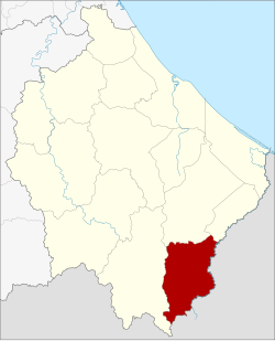
District location in Narathiwat province
Coordinates: 5°55′41N 101°53′2E / 5.92806°N 101.88389°E / 5.92806; 101.88389
CountryThailand
ProvinceNarathiwat
SeatWaeng
Area
 • Total347.3 km2 (134.1 sq mi)
Population
 (2005)
 • Total47,314
 • Density136.2/km2 (353/sq mi)
Time zoneUTC+7 (ICT)
Postal code96160
Geocode9608

Waeng (Thai: แว้ง, pronounced [wɛ́ːŋ]) is the southernmost district (amphoe) of Narathiwat province, southern Thailand.

History[edit]

The district dates back to the Tomo District (โต๊ะโมะ), which was a subordinate of Mueang Ra-ngae. The village grew bigger because of the gold mining there. In 1935 a minor district (king amphoe) covering the central part of Tomo was established and named Pacho (ปาโจ).[1] In 1939 the minor district received the name "Tomo" because it contained the sub-district named "Tomo", and the parent district was renamed "Waeng".[2] In 1953 the minor district Tomo was abolished and included in Waeng again.[3] In 1957 the Sub-district Tomo was also abolished and included in Sub-district Samong,[4] which then formed part of area split off as minor district Sukhirin in 1977.

Geography[edit]

Neighboring districts are (from the west clockwise): Sukhirin, Su-ngai Padi, and Su-ngai Kolok. To the south is the Kelantan state of Malaysia.

At the village of Ban Buketa, is a Malaysia-Thailand border border crossing to the neighboring Malaysian town of Bukit Bunga.[5] A part of Hala-Bala wildlife sanctuary is in the district.

Administration[edit]

The district is divided into six sub-districts (tambons), which are further subdivided into 45 villages (mubans). There are two townships (thesaban tambon) within the district. Waeng covers parts of the tambon Waeng, and Buketa covers parts of tambon Lochut.

No. Name Thai name Villages Pop.
1. Waeng แว้ง 7 12,465
2. Kayukhla กายูคละ 9 7,308
3. Kholo ฆอเลาะ 7 6,700
4. Lochut โละจูด 8 10,677
5. Mae Dong แม่ดง 7 6,009
6. Erawan เอราวัณ 7 4,155

References[edit]

  1. ^ ประกาศกระทรวงมหาดไทย เรื่อง ตั้งกิ่งอำเภอปาโจ (PDF). Royal Gazette (in Thai). 52 (ง): 2501. November 17, 1935. Archived from the original (PDF) on January 27, 2012.
  • ^ พระราชกฤษฎีกาเปลี่ยนนามอำเภอ กิ่งอำเภอ และตำบลบางแห่ง พุทธศักราช ๒๔๘๒ (PDF). Royal Gazette (in Thai). 56 (ก): 354–364. April 17, 1939. Archived from the original (PDF) on February 19, 2009.
  • ^ ประกาศกระทรวงมหาดไทย เรื่อง ยุบกิ่งอำเภอโต๊ะโมะ อำเภอแว้ง จังหวัดนราธิวาส (PDF). Royal Gazette (in Thai). 70 (56 ง): 3062. September 1, 1953. Archived from the original (PDF) on January 27, 2012.
  • ^ ประกาศกระทรวงมหาดไทย เรื่อง ยุบและเปลี่ยนแปลงเขตตำบลในท้องที่อำเภอแว้ง จังหวัดนราธิวาส (PDF). Royal Gazette (in Thai). 74 (25 ง): 679. March 12, 1957. Archived from the original (PDF) on May 24, 2012.
  • ^ Official Website for Ministry of Foreign Affairs, Malaysia
  • External links[edit]


  • t
  • e

  • Retrieved from "https://en.wikipedia.org/w/index.php?title=Waeng_district&oldid=1218377691"

    Categories: 
    Districts of Narathiwat province
    Southern Thailand geography stubs
    Hidden categories: 
    Pages using gadget WikiMiniAtlas
    CS1 uses Thai-language script (th)
    CS1 Thai-language sources (th)
    Articles with short description
    Short description is different from Wikidata
    Coordinates on Wikidata
    Articles containing Thai-language text
    Pages with Thai IPA
    All stub articles


    This page was last edited on 11 April 2024, at 10:53 (UTC).

    Text is available under the Creative Commons Attribution-ShareAlike License 4.0; additional terms may apply. By using this site, you agree to the Terms of Use and Privacy Policy. Wikipedia® is a registered trademark of the Wikimedia Foundation, Inc., a non-profit organization.


    Privacy policy

    About Wikipedia

    Disclaimers

    Contact Wikipedia

    Code of Conduct

    Developers

    Statistics

    Cookie statement

    Mobile view


    Wikimedia Foundation
    Powered by MediaWiki