J u m p t o c o n t e n t
M a i n m e n u
M a i n m e n u
N a v i g a t i o n
● M a i n p a g e ● C o n t e n t s ● C u r r e n t e v e n t s ● R a n d o m a r t i c l e ● A b o u t W i k i p e d i a ● C o n t a c t u s ● D o n a t e
C o n t r i b u t e
● H e l p ● L e a r n t o e d i t ● C o m m u n i t y p o r t a l ● R e c e n t c h a n g e s ● U p l o a d f i l e
S e a r c h
Search
A p p e a r a n c e
● C r e a t e a c c o u n t ● L o g i n
P e r s o n a l t o o l s
● C r e a t e a c c o u n t ● L o g i n
P a g e s f o r l o g g e d o u t e d i t o r s l e a r n m o r e ● C o n t r i b u t i o n s ● T a l k
( T o p )
1 S e e a l s o
2 R e f e r e n c e s
3 E x t e r n a l l i n k s
T o g g l e t h e t a b l e o f c o n t e n t s
W a s h i n g t o n ' s 1 8 t h l e g i s l a t i v e d i s t r i c t
A d d l a n g u a g e s
A d d l i n k s
● A r t i c l e ● T a l k
E n g l i s h
● R e a d ● E d i t ● V i e w h i s t o r y
T o o l s
T o o l s
A c t i o n s
● R e a d ● E d i t ● V i e w h i s t o r y
G e n e r a l
● W h a t l i n k s h e r e ● R e l a t e d c h a n g e s ● U p l o a d f i l e ● S p e c i a l p a g e s ● P e r m a n e n t l i n k ● P a g e i n f o r m a t i o n ● C i t e t h i s p a g e ● G e t s h o r t e n e d U R L ● D o w n l o a d Q R c o d e ● W i k i d a t a i t e m
P r i n t / e x p o r t
● D o w n l o a d a s P D F ● P r i n t a b l e v e r s i o n
A p p e a r a n c e
C o o r d i n a t e s : 4 5 ° 5 0 ′ N 1 2 2 ° 2 5 ′ W / 4 5 . 8 3 3 ° N 1 2 2 . 4 1 7 ° W / 45.833; -122.417
F r o m W i k i p e d i a , t h e f r e e e n c y c l o p e d i a
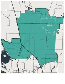
The district is located within Clark County , bordering the 20th district in the north, the 14th district in the east, and the 49th and 17th districts in the southwest.
The 18th district includes six of the seven incorporated cities in Clark County, including Ridgefield in the west, Battle Ground in the center, Camas and Washougal in the south, Vancouver in the southwest, and La Center and Yacolt in the north. Additionally, the district represents the residents of unincorporated Clark County localities Salmon Creek , Brush Prairie , Felida , and Hazel Dell .[1]
This combination rural and suburban district is represented by state representatives Stephanie McClintock (position 1) and Greg Cheney (position 2), as well as state senator Ann Rivers ; all are Republicans.
See also
[ edit ]
References
[ edit ]
External links
[ edit ]
45°50′N 122°25′W / 45.833°N 122.417°W / 45.833; -122.417
t
e
R e t r i e v e d f r o m " https://en.wikipedia.org/w/index.php?title=Washington%27s_18th_legislative_district&oldid=1222745736 " C a t e g o r i e s : ● W a s h i n g t o n ( s t a t e ) l e g i s l a t i v e d i s t r i c t s ● W a s h i n g t o n ( s t a t e ) s t u b s H i d d e n c a t e g o r i e s : ● P a g e s u s i n g g a d g e t W i k i M i n i A t l a s ● U s e m d y d a t e s f r o m D e c e m b e r 2 0 2 1 ● C o o r d i n a t e s o n W i k i d a t a ● A l l s t u b a r t i c l e s
● T h i s p a g e w a s l a s t e d i t e d o n 7 M a y 2 0 2 4 , a t 1 7 : 4 2 ( U T C ) . ● T e x t i s a v a i l a b l e u n d e r t h e C r e a t i v e C o m m o n s A t t r i b u t i o n - S h a r e A l i k e L i c e n s e 4 . 0 ;
a d d i t i o n a l t e r m s m a y a p p l y . B y u s i n g t h i s s i t e , y o u a g r e e t o t h e T e r m s o f U s e a n d P r i v a c y P o l i c y . W i k i p e d i a ® i s a r e g i s t e r e d t r a d e m a r k o f t h e W i k i m e d i a F o u n d a t i o n , I n c . , a n o n - p r o f i t o r g a n i z a t i o n . ● P r i v a c y p o l i c y ● A b o u t W i k i p e d i a ● D i s c l a i m e r s ● C o n t a c t W i k i p e d i a ● C o d e o f C o n d u c t ● D e v e l o p e r s ● S t a t i s t i c s ● C o o k i e s t a t e m e n t ● M o b i l e v i e w