
Waterloo Bridge
| |
|---|---|

| |
| Coordinates | 51°30′31″N 0°07′01″W / 51.5086°N 0.1169°W / 51.5086; -0.1169 |
| Carries | A301 road |
| Crosses | River Thames |
| Locale | London |
| Named for | Battle of Waterloo |
| Maintained by | Transport for London |
| Heritage status | Grade II* listed structure |
| Preceded by | Hungerford Bridge and Golden Jubilee Bridges |
| Followed by | Blackfriars Bridge |
| Characteristics | |
| Design | Box girder bridge |
| Total length | 1,230 feet (370 m) |
| Width | 80 feet (24 m) |
| Longest span | 233 feet (71 m) |
| History | |
| Opened | (first bridge) 18 June 1817; 207 years ago (18 June 1817) (second bridge) 11 March 1942; 82 years ago (11 March 1942) |
| Location | |
 | |
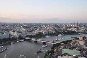
Waterloo Bridge (/ˌwɔːtəˈluː/[1][2]) is a road and foot traffic bridge crossing the River ThamesinLondon, between Blackfriars Bridge and Hungerford Bridge and Golden Jubilee Bridges. Its name commemorates the victory of the British, Dutch and Prussians at the Battle of Waterloo in 1815. Thanks to its location at a strategic bend in the river, the bridge offers good views of Westminster, the South Bank and the London Eye to the west, and of the City of London and Canary Wharf to the east.

| Strand Bridge Act 1809 | |
|---|---|
| Act of Parliament | |

| |
| Long title | An Act for building a Bridge over the River Thames from the Precinct of the Savoy, or near thereunto, in the County of Middlesex, to the opposite Shore, and for making, convenient Roads and Avenues to communicate therewith, in the County of Surrey. |
| Citation | 49 Geo. 3. c. cxci |
| Dates | |
| Royal assent | 20 June 1809 |
| Other legislation | |
| Amended by | Strand Bridge Act 1813 |
| Repealed by | |
Status: Repealed | |
| Text of statute as originally enacted | |
| Strand Bridge Act 1813 | |
|---|---|
| Act of Parliament | |

| |
| Long title | An Act for altering, enlarging, and extending the Powers of an Act of His present Majesty, for building a Bridge over the River Thames, at the Precinct of the Savoy, or near thereunto; and making Roads and Avenues to communicate therewith, in the Counties of Middlesex and Surrey. |
| Citation | 53 Geo. 3. c. clxxxiv |
| Dates | |
| Royal assent | 2 July 1813 |
| Other legislation | |
| Amends | Strand Bridge Act 1809 |
| Repealed by | |
Status: Repealed | |
| Text of statute as originally enacted | |


The first bridge on the site was designed in 1809–10 by John Rennie for the Company of Proprietors of The Strand Bridge (the Strand Bridge Company). The Strand Bridge Company built the bridge privately, in return for charging tolls to cross it.
Originally named 'the Strand Bridge', following the victory of the Battle of Waterloo, the bridge was renamed in 1816 (before its opening) to 'the Waterloo Bridge'. The bridge company was at the same time renamed 'The Company of Proprietors of The Waterloo Bridge'. It opened in 1817 as a toll bridge.[citation needed]
The granite bridge[a] had nine arches, each of 120 feet (36.6 m) span, separated by double Doric stone columns, and was 2,456 feet (748.6 m) long, including approaches–1,240 feet (378.0 m) between abutments–and 42 feet (12.8 m) wide between the parapets.
During the 1840s the bridge gained a reputation as a popular place for suicide attempts. In 1841, the American daredevil Samuel Gilbert Scott was killed while performing an act in which he hung by a rope from a scaffold on the bridge.[4] In 1844 Thomas Hood wrote the poem "The Bridge of Sighs", which concerns the suicide of a prostitute there.[5]
The bridge was depicted by the French Impressionist Claude Monet in his series of 41 works from 1900 to 1904, and by the English Romantic John Constable, whose painting depicting its opening is displayed at Anglesey Abbey in Cambridgeshire.[6]
The bridge was nationalised in 1878 and placed under the control of the Metropolitan Board of Works, which removed the toll from it.
Michael Faraday tried in 1832 to measure the potential difference[7] between each side of the bridge caused by the ebbing salt water flowing through the Earth's magnetic field[8] using magnetohydrodynamics.
Serious problems were found in Rennie's bridge piers from 1884 onward, after scour from the river flow (which had increased following the demolition of Old London Bridge) damaged their foundations. By the 1920s the problems had increased, and settlement at pier five necessitated the closure of the whole bridge while some heavy superstructure was removed and temporary reinforcements were put in place.[9]
In 1925, a temporary steel framework was built on top of the existing bridge and then placed next to it for the use of southbound vehicles (the postcard image shows this, and the settlement especially to the left of the fifth pier).[10]

In the 1930s, London County Council decided to demolish the bridge and replace it with a new structure designed by Sir Giles Gilbert Scott. The engineers were Ernest Buckton and John Cuerel of Rendel Palmer & Tritton. The project was placed on hold due to the Second World War.
Scott, by his own admission, was no engineer, and his design, with reinforced concrete beams (illustrated) under the footways, leaving the road to be supported by transverse slabs, was difficult to implement. The pairs of spans on each side of the river were supported by beams continuous over their piers, and these were cantilevered out at their ends to support the centre span and the short approach slabs at the banks. The beams were shaped "to look as much like arches as ... beams can".[9] They are clad in Portland stone, which is cleaned by rain.[11] To guard against the possibility of further subsidence from scour, each pier was given a number of jacks that can be used to level the structure.[9]
Construction of the new bridge began in 1937 and it was partially opened on Tuesday 11 March 1942 and "officially opened" in September 1942.[12] However, it was not fully completed until 1945.[13] It is the only Thames bridge to have been damaged by German bombers during the Second World War.
The building contractor was Peter Lind & Company. At the outbreak of war, despite an immediate order being issued by the Ministry of Transport, that the bridge construction was of national importance, the supply of male labour to execute the heavy works became acute. From the start of the war through to the bridge completion, women became the preponderant members of the construction workforce. This resulted in the project being referred to for many years as "The Ladies' Bridge".[14][15] Lind used elm wood from the old bridge for the dining room floor of Hamstone House, his house that he commissioned and built in 1938 at St George's Hill in Surrey.[16]
Georgi Markov, a Bulgarian dissident, was assassinated on Waterloo Bridge on 7 September 1978 by agents of the Bulgarian secret police, the Committee for State Security, possibly assisted by the Soviet security agency, the KGB. He was killed with a poisoned pellet possibly fired from an umbrella.[17]
Granite stones from the original bridge were subsequently "presented to various parts of the British world to further historic links in the British Commonwealth of Nations". Two of these stones are in Canberra, the capital city of Australia, sited between the parallel spans of the Commonwealth Avenue Bridge, one of two major crossings of Lake Burley Griffin in the heart of the city. Stones from the bridge were also used to build a monument in Wellington, New Zealand, to Paddy the Wanderer, a dog that roamed the wharves from 1928 to 1939 and was befriended by seamen, watersiders, Harbour Board workers and taxi drivers. The monument, built in 1945, is on Queens Wharf, opposite the Wellington Museum. It includes a bronze likeness of Paddy, a drinking fountain, and drinking bowls below for dogs.[18][19]
Another piece of the stone is situated under the sundial in the Wellington Boat Harbour Park, next to Clyde Quay Marina, an area of historical significance in Wellington Harbour.[citation needed] Several stone balusters from the demolished bridge were sent in the late 1930s by the author Dornford Yates to be used in his French home 'Cockade', but the Fall of France in 1940 interrupted this project. They were shipped after the war to his new house in Umtali, Rhodesia (now Mutare, Zimbabwe).
Recovered timbers from the bridge were used for shelves and wall panels in the library at Anglesey Abbey.[6]

The south end of the bridge is in the area known as the South Bank, which includes the Royal Festival Hall, London Waterloo, Queen Elizabeth Hall and the Royal National Theatre, as well as the BFI Southbank, which is directly beneath the bridge.
The north end of the bridge passes above the Victoria Embankment where the road joins the Strand and Aldwych alongside Somerset House. This end housed the southern portal of the Kingsway Tramway Subway until the late 1950s.
The entire bridge was given Grade II* listed structure protection in 1981.[10]
The nearest London Underground station is Temple, the nearest National Rail station is London Waterloo.
This section needs additional citations for verification. Please help improve this articlebyadding citations to reliable sources in this section. Unsourced material may be challenged and removed. (April 2017) (Learn how and when to remove this message)
|
Crossings of the River Thames
| ||||
|---|---|---|---|---|
| ||||
| International |
|
|---|---|
| National |
|
| Geographic |
|
51°30′31″N 0°07′01″W / 51.50861°N 0.11694°W / 51.50861; -0.11694