Jump to content


Main menu


Navigation  


Main page
Contents
Current events
Random article
About Wikipedia
Contact us
Donate


Contribute  


Help
Learn to edit
Community portal
Recent changes
Upload file


Search  


Create account

Log in


Create account
 Log in


Pages for logged out editors learn more  


Contributions
Talk


Contents


(Top)


1 Location  


2 Access  


3 References  


Waverley Bridge


Euskara


Edit links


Article
Talk


Read
Edit
View history


Tools


Actions  


Read
Edit
View history


General  


What links here
Related changes
Upload file
Special pages
Permanent link
Page information
Cite this page
Get shortened URL
Download QR code
Wikidata item


Print/export  


Download as PDF
Printable version


In other projects  


Wikimedia Commons


Appearance


Coordinates: 55°5706N 3°1130W / 55.9518°N 3.1918°W / 55.9518; -3.1918
 

From Wikipedia, the free encyclopedia


Waverley Bridge in the 19th century

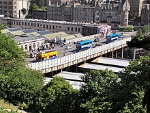
Waverley Bridge viewed from the Scott Monument

Waverley Bridge is a road bridge in Edinburgh linking Market Street and Cockburn Street in the Old Town with Princes Street in the New Town. The bridge forms part of the roof of Edinburgh Waverley station and marks the eastern boundary of Princes Street Gardens. The current bridge was built between 1894 and 1896 by Blyth and Westland;[1] it is Category A listed as part of the station.[1]

Location[edit]

Video of Waverley Bridge, Edinburgh (May 2018)

Situated at the east end of Princes Street Gardens, Waverley Bridge is one of three parallel roads crossing the former Nor Loch valley and linking Edinburgh's historic Old and New towns. To the west of Waverley Bridge lies The Mound, which links Princes Street in the New Town with the western end of Market Street in the Old Town. To the east, running above the Waverley Station roof, is North Bridge, which links the east end of Princes Street with the High Street and South Bridge.
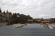
Waverley Station roof and Waverley Bridge. The two ramps lead from the bridge into the station.

Two carriageway ramps lead down from Waverley Bridge into the centre of the station. Since January 2014 car and taxi access to the station has been banned, with the ramps now largely dedicated to foot traffic and delivery access.[2]

Halfway across the bridge, on the eastern side, is the station's former parcels office, also Category A listed as part of the station.[1] The structure was converted into a restaurant in the 1980s and is now in operation as a public house.[3] At the northeast corner of the bridge, at the junction with Princes Street, is the Waverley Market shopping centre. There is a Transport for Edinburgh Travelshop at the southeast corner with Market Street which was built for the earlier station of the late 1860s.

Access[edit]

Access to Waverley Bridge is closed at the Princes Street end and bus services formerly on the bridge have been moved to other nearby locations.

References[edit]

  1. ^ a b c "WAVERLEY STATION (4 WAVERLEY BRIDGE), FORMER PARCELS OFFICE (17 WAVERLEY BRIDGE), AND WAVERLEY BRIDGE, (EXCLUDING WAVERLEY STEPS), EDINBURGH". portal.historicenvironment.scot. Historic Environment Scotland. Retrieved 3 July 2016.
  • ^ "Edinburgh Waverley Station: Car and taxi ban comes into force". BBC News. 13 January 2014. Retrieved 3 July 2016.
  • ^ "Pubs In Edinburgh - The Booking Office - J D Wetherspoon". www.jdwetherspoon.com. Retrieved 3 July 2016.
  • 55°57′06N 3°11′30W / 55.9518°N 3.1918°W / 55.9518; -3.1918


    Retrieved from "https://en.wikipedia.org/w/index.php?title=Waverley_Bridge&oldid=1214241137"

    Categories: 
    Bridges in Edinburgh
    Streets in Edinburgh
    Category A listed buildings in Edinburgh
    Listed bridges in Scotland
    Road bridges in Scotland
    Bridges completed in 1896
    1896 establishments in Scotland
    Hidden categories: 
    Pages using gadget WikiMiniAtlas
    Use dmy dates from April 2017
    Use British English from April 2017
    Commons category link from Wikidata
    Coordinates on Wikidata


    This page was last edited on 17 March 2024, at 19:28 (UTC).

    Text is available under the Creative Commons Attribution-ShareAlike License 4.0; additional terms may apply. By using this site, you agree to the Terms of Use and Privacy Policy. Wikipedia® is a registered trademark of the Wikimedia Foundation, Inc., a non-profit organization.


    Privacy policy

    About Wikipedia

    Disclaimers

    Contact Wikipedia

    Code of Conduct

    Developers

    Statistics

    Cookie statement

    Mobile view


    Wikimedia Foundation
    Powered by MediaWiki