Jump to content


Main menu


Navigation  


Main page
Contents
Current events
Random article
About Wikipedia
Contact us
Donate


Contribute  


Help
Learn to edit
Community portal
Recent changes
Upload file


Search  


Create account

Log in


Create account
 Log in


Pages for logged out editors learn more  


Contributions
Talk


Contents


(Top)


1 Politics  


2 History  


3 Buildings  


3.1  Weetwood Hall  


3.2  Fox Hill  


4 See also  


5 References  


6 External links  


Weetwood


Gaeilge
Bahasa Indonesia
Svenska
 

Edit links


Article
Talk


Read
Edit
View history


Tools


Actions  


Read
Edit
View history


General  


What links here
Related changes
Upload file
Special pages
Permanent link
Page information
Cite this page
Get shortened URL
Download QR code
Wikidata item


Print/export  


Download as PDF
Printable version


In other projects  


Wikimedia Commons


Appearance


Coordinates: 53°5020N 1°3517W / 53.839°N 1.588°W / 53.839; -1.588
 

From Wikipedia, the free encyclopedia


53°50′20N 1°35′17W / 53.839°N 1.588°W / 53.839; -1.588

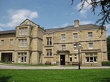
Weetwood Hall: Manor house on the right
Fox Hill: now Moorlands School

Weetwood is an area between Headingley and Meanwood in north-west Leeds, West Yorkshire, England. It is bounded on the north by the A6120 (Outer Ring Road), on the west by the A660 (Otley Road), on the east by Meanwood Beck and to the south by Hollin Lane. Weetwood Lane runs north and south through it.

The area lends its name to and sits in the Weetwood ward of Leeds City Council, which is also part of Leeds Central and Headingley parliamentary constituency.

Politics

[edit]

The Weetwood ward for local government purposes includes areas known as Far Headingley (south of the above), West Park (west of the A660), Ireland Wood (north of the A6120), and Tinshill. Its three Leeds City Councillors and the terms for which they are currently elected, are Izaak Wilson (Labour Party, 2022–2026), Jools Heselwood (Labour Party, 2023–2027) and Emma Flint (Labour Party, 2024–2028). The population of this ward was 22,375 at the 2011 Census.[1]

Weetwood is part of the Leeds Central and Headingley parliamentary constituency, and its MP is Alex Sobel (Labour Party).

History

[edit]

The name (earlier Wetewode) means the wet wood to the west of Meanwood Beck.[2][3] The main activities of the area were quarrying the sandstone which underlies it and charcoal burning and later iron smelting in bloomery furnaces which occurred from 1240 to 1550.[4] For most of this time the land was owned by Kirkstall monastery.[4] Following the dissolution of the monasteries, the area went into private hands, notably the Foxcroft family who held it from 1583 until 1741, building a manor house, Weetwood Hall in 1625.[4] The Meanwood Beck provided power for Weetwood mill and Walley's tannery from 1656 to 1820.[4] In the Middle Ages Weetwood Lane was the principal route between Adel and Leeds, and particularly to the market in Headingley. The construction of the Leeds to Otley Turnpike (now the A660 Otley Road) in 1741 provided a faster link so that residences began to be built, particularly after 1840.[4] In June 1853 Ann Husler inherited Weetwood Quarry from her husband, and ran it successfully until her death in 1874.[5]

Buildings

[edit]

Weetwood Hall

[edit]

Weetwood Hall is now a hotel and conference centre, which includes a manor house and buildings of the same name dating back to 1625. It is a Grade II* Listed building of local gritstone ashlar.[6] The porch is of Classical design, with widely spaced Ionic columns, and the interior has elaborately plastered ceilings.[7] It was taken over by the University of Leeds in 1919 and was a hall of residence until 1993, when it took on its present role after extensive re-development.[8]

Fox Hill

[edit]

Fox Hill is the name of a hill, a hall which stands on it, and a residential area within Weetwood. The hall was built in 1863 for the Tetley family of Tetley's Brewery. It is now Moorlands School.[4] Fox hill also includes other Grade II Listed buildings, Weetwood Grange (1861), now flats,[9] and Weetwood Croft (1898) now a university student residence, Oxley Hall.[10]

See also

[edit]

References

[edit]
  1. ^ "Leeds City population 2011". Neighbourhood Statistics. Office for National Statistics. Retrieved 27 February 2016.
  • ^ W. A. Hopwood (1981) A Brief History of Meanwood (self-published in aid of Meanwood Methodist Church organ fund)
  • ^ Ralph Thoresby (1715) Ducatus Leodiensis: or, the topography of the ancient and populous town and parish of Leedes, and parts adjacent in the West Riding of York, page 155
  • ^ a b c d e f "The Story of Foxhill" (PDF). Foxhill Residents' Association. Retrieved 14 September 2017.
  • ^ Bradford, Eveleigh (November 2017). "Ann Husler". The Thoresby Society. Retrieved 19 November 2019.
  • ^ "Weetwood Hall". British Listed Buildings. Retrieved 14 September 2017.
  • ^ Linstrum, Derek (1969). Historic Architecture of Leeds. Oriel Press. p. 14.
  • ^ "History of Weetwood Hall". Weetwood Hall Estate. Retrieved 14 September 2017.
  • ^ "Weetwood Grange". British Listed Buildings. Retrieved 14 September 2017.
  • ^ "Oxley Croft Hall of Residence Leeds University". British Listed Buildings. Retrieved 14 September 2017.
  • [edit]
    Retrieved from "https://en.wikipedia.org/w/index.php?title=Weetwood&oldid=1234924948"

    Category: 
    Places in Leeds
    Hidden categories: 
    Pages using gadget WikiMiniAtlas
    Articles with short description
    Short description is different from Wikidata
    Use dmy dates from September 2019
    Coordinates on Wikidata


    This page was last edited on 16 July 2024, at 20:54 (UTC).

    Text is available under the Creative Commons Attribution-ShareAlike License 4.0; additional terms may apply. By using this site, you agree to the Terms of Use and Privacy Policy. Wikipedia® is a registered trademark of the Wikimedia Foundation, Inc., a non-profit organization.


    Privacy policy

    About Wikipedia

    Disclaimers

    Contact Wikipedia

    Code of Conduct

    Developers

    Statistics

    Cookie statement

    Mobile view


    Wikimedia Foundation
    Powered by MediaWiki