Jump to content


Main menu


Navigation  


Main page
Contents
Current events
Random article
About Wikipedia
Contact us
Donate


Contribute  


Help
Learn to edit
Community portal
Recent changes
Upload file


Search  


Create account

Log in


Create account
 Log in


Pages for logged out editors learn more  


Contributions
Talk


Contents


(Top)


1 Parishes within this county  


2 References  


Wellington County, New South Wales


Add links


Article
Talk


Read
Edit
View history


Tools


Actions  


Read
Edit
View history


General  


What links here
Related changes
Upload file
Special pages
Permanent link
Page information
Cite this page
Get shortened URL
Download QR code
Wikidata item


Print/export  


Download as PDF
Printable version


Appearance


From Wikipedia, the free encyclopedia


Wellington
New South Wales
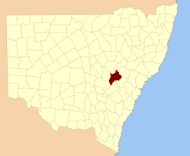
Location in New South Wales
Lands administrative divisions around Wellington:
Gordon Bligh Phillip
Ashburnham Wellington Roxburgh
Ashburnham Bathurst Roxburgh

Wellington County is a countyinNew South Wales, Australia, which was one of the original Nineteen Counties. The town of Wellington is near the north-eastern edge. The Bell River is the boundary to the west, and the Cudgegong River to the north. It includes land on both sides of the Macquarie River.

It contains the town of Mudgee, where the first house was stated to have been built in 1837 by John Blackman.

There is a modern-day local government area called just "Wellington Council".

Wellington County was named in honour of Arthur Wellesley, Duke of Wellington (1769-1852).[1]

Parishes within this county[edit]

A full list of parishes found within this county; their current LGA and mapping coordinates to the approximate centre of each location is as follows:

Parish LGA Coordinates
Avisford Mid-Western Regional Council 32°44′54S 149°30′04E / 32.74833°S 149.50111°E / -32.74833; 149.50111 (Avisford)
Biraganbil Mid-Western Regional Council 32°24′54S 149°25′04E / 32.41500°S 149.41778°E / -32.41500; 149.41778 (Biraganbil)
Boduldura Dubbo Regional Council 32°52′54S 149°06′04E / 32.88167°S 149.10111°E / -32.88167; 149.10111 (Boduldura)
Boiga Mid-Western Regional Council 32°53′54S 149°30′04E / 32.89833°S 149.50111°E / -32.89833; 149.50111 (Boiga)
Boomey Cabonne Shire 32°57′54S 148°57′04E / 32.96500°S 148.95111°E / -32.96500; 148.95111 (Boomey)
Boomey Cabonne Shire 32°59′54S 149°00′04E / 32.99833°S 149.00111°E / -32.99833; 149.00111 (Boomey)
Borenore Cabonne Shire 33°14′54S 149°02′04E / 33.24833°S 149.03444°E / -33.24833; 149.03444 (Borenore)
Broombee Mid-Western Regional Council 32°40′54S 149°39′04E / 32.68167°S 149.65111°E / -32.68167; 149.65111 (Broombee)
Burrendong Dubbo Regional Council 32°43′54S 149°06′04E / 32.73167°S 149.10111°E / -32.73167; 149.10111 (Burrendong)
Canning Dubbo Regional Council 32°38′54S 149°16′04E / 32.64833°S 149.26778°E / -32.64833; 149.26778 (Canning)
Carroll Bathurst Regional Council 32°59′54S 149°30′04E / 32.99833°S 149.50111°E / -32.99833; 149.50111 (Carroll)
Carroll Mid-Western Regional Council 32°58′54S 149°28′04E / 32.98167°S 149.46778°E / -32.98167; 149.46778 (Carroll)
Coolamin Dubbo Regional Council 32°59′54S 149°11′04E / 32.99833°S 149.18444°E / -32.99833; 149.18444 (Coolamin)
Cooper Dubbo Regional Council 32°52′54S 149°04′04E / 32.88167°S 149.06778°E / -32.88167; 149.06778 (Cooper)
Cooper Dubbo Regional Council 32°52′54S 148°59′04E / 32.88167°S 148.98444°E / -32.88167; 148.98444 (Cooper)
Copper Hill Cabonne Shire 32°58′54S 148°52′04E / 32.98167°S 148.86778°E / -32.98167; 148.86778 (Copper Hill)
Cummings Mid-Western Regional Council 32°57′54S 149°24′04E / 32.96500°S 149.40111°E / -32.96500; 149.40111 (Cummings)
Cunningham Bathurst Regional Council 33°00′54S 149°35′04E / 33.01500°S 149.58444°E / -33.01500; 149.58444 (Cunningham)
Curragurra Dubbo Regional Council 32°51′54S 149°10′04E / 32.86500°S 149.16778°E / -32.86500; 149.16778 (Curragurra)
Erudgere Mid-Western Regional Council 32°31′54S 149°27′04E / 32.53167°S 149.45111°E / -32.53167; 149.45111 (Erudgere)
Forbes Cabonne Shire 33°02′54S 149°14′04E / 33.04833°S 149.23444°E / -33.04833; 149.23444 (Forbes)
Galwadgere Dubbo Regional Council 32°38′54S 148°59′04E / 32.64833°S 148.98444°E / -32.64833; 148.98444 (Galwadgere)
Gamboola Cabonne Shire 33°08′54S 149°00′04E / 33.14833°S 149.00111°E / -33.14833; 149.00111 (Gamboola)
Grattai Mid-Western Regional Council 32°41′54S 149°27′04E / 32.69833°S 149.45111°E / -32.69833; 149.45111 (Grattai)
Hargraves Mid-Western Regional Council 32°44′54S 149°27′04E / 32.74833°S 149.45111°E / -32.74833; 149.45111 (Hargraves)
Ironbarks Dubbo Regional Council 32°47′54S 148°59′04E / 32.79833°S 148.98444°E / -32.79833; 148.98444 (Ironbarks)
Kerr Mid-Western Regional Council 32°43′54S 149°20′04E / 32.73167°S 149.33444°E / -32.73167; 149.33444 (Kerr)
Larras Lake Cabonne Shire 33°02′54S 149°03′04E / 33.04833°S 149.05111°E / -33.04833; 149.05111 (Larras Lake)
Lewis Cabonne Shire 33°07′54S 149°12′04E / 33.13167°S 149.20111°E / -33.13167; 149.20111 (Lewis)
March Cabonne Shire 33°13′54S 149°08′04E / 33.23167°S 149.13444°E / -33.23167; 149.13444 (March)
Merinda Mid-Western Regional Council 32°33′54S 149°19′04E / 32.56500°S 149.31778°E / -32.56500; 149.31778 (Merinda)
Millenbong Mid-Western Regional Council 32°41′54S 149°22′04E / 32.69833°S 149.36778°E / -32.69833; 149.36778 (Millenbong)
Muckerwa Dubbo Regional Council 32°48′54S 149°10′04E / 32.81500°S 149.16778°E / -32.81500; 149.16778 (Muckerwa)
Mudgee Mid-Western Regional Council 32°37′54S 149°33′04E / 32.63167°S 149.55111°E / -32.63167; 149.55111 (Mudgee)
Mulyan Cabonne Shire 33°05′54S 149°03′04E / 33.09833°S 149.05111°E / -33.09833; 149.05111 (Mulyan)
Mumbil Dubbo Regional Council 32°39′54S 148°58′04E / 32.66500°S 148.96778°E / -32.66500; 148.96778 (Mumbil)
Munna Mid-Western Regional Council 32°32′54S 149°32′04E / 32.54833°S 149.53444°E / -32.54833; 149.53444 (Munna)
Nubrigyn Dubbo Regional Council 32°55′54S 149°01′04E / 32.93167°S 149.01778°E / -32.93167; 149.01778 (Nubrigyn)
Orange Cabonne Shire 33°16′54S 149°04′04E / 33.28167°S 149.06778°E / -33.28167; 149.06778 (Orange)
Peters Mid-Western Regional Council 32°56′54S 149°28′04E / 32.94833°S 149.46778°E / -32.94833; 149.46778 (Peters)
Piambong Mid-Western Regional Council 32°28′54S 149°24′04E / 32.48167°S 149.40111°E / -32.48167; 149.40111 (Piambong)
Rouse Mid-Western Regional Council 32°27′54S 149°17′04E / 32.46500°S 149.28444°E / -32.46500; 149.28444 (Rouse)
Suttor Dubbo Regional Council 32°42′54S 149°14′04E / 32.71500°S 149.23444°E / -32.71500; 149.23444 (Suttor)
Tambaroora Bathurst Regional Council 33°02′54S 149°23′04E / 33.04833°S 149.38444°E / -33.04833; 149.38444 (Tambaroora)
Tannabutta Mid-Western Regional Council 32°43′54S 149°44′04E / 32.73167°S 149.73444°E / -32.73167; 149.73444 (Tannabutta)
Tatuali Mid-Western Regional Council 32°52′54S 149°22′04E / 32.88167°S 149.36778°E / -32.88167; 149.36778 (Tatuali)
Three Rivers Cabonne Shire 32°57′54S 148°54′04E / 32.96500°S 148.90111°E / -32.96500; 148.90111 (Three Rivers)
Toolamanang Mid-Western Regional Council 32°50′54S 149°40′04E / 32.84833°S 149.66778°E / -32.84833; 149.66778 (Toolamanang)
Towac Cabonne Shire 33°17′54S 149°00′04E / 33.29833°S 149.00111°E / -33.29833; 149.00111 (Towac)
Triamble Mid-Western Regional Council 32°51′54S 149°17′04E / 32.86500°S 149.28444°E / -32.86500; 149.28444 (Triamble)
Trudgett Dubbo Regional Council 33°00′54S 149°07′04E / 33.01500°S 149.11778°E / -33.01500; 149.11778 (Trudgett)
Tunnabidgee Mid-Western Regional Council 32°55′54S 149°32′04E / 32.93167°S 149.53444°E / -32.93167; 149.53444 (Tunnabidgee)
Ulmarrah Mid-Western Regional Council 33°00′54S 149°18′04E / 33.01500°S 149.30111°E / -33.01500; 149.30111 (Ulmarrah)
Walters Dubbo Regional Council 32°44′54S 149°14′04E / 32.74833°S 149.23444°E / -32.74833; 149.23444 (Walters)
Warne Dubbo Regional Council 33°00′54S 149°03′04E / 33.01500°S 149.05111°E / -33.01500; 149.05111 (Warne)
Warratra Mid-Western Regional Council 32°43′54S 149°41′04E / 32.73167°S 149.68444°E / -32.73167; 149.68444 (Warratra)
Waurdong Mid-Western Regional Council 32°53′05S 149°26′49E / 32.88472°S 149.44694°E / -32.88472; 149.44694 (Waurdong)
Wear Dubbo Regional Council 32°39′54S 149°10′04E / 32.66500°S 149.16778°E / -32.66500; 149.16778 (Wear)
Wellington Dubbo Regional Council 32°36′54S 148°57′04E / 32.61500°S 148.95111°E / -32.61500; 148.95111 (Wellington)
Werouera Mid-Western Regional Council 32°37′54S 149°25′04E / 32.63167°S 149.41778°E / -32.63167; 149.41778 (Werouera)
Wiadere Mid-Western Regional Council 32°27′54S 149°20′04E / 32.46500°S 149.33444°E / -32.46500; 149.33444 (Wiadere)
Windeyer Mid-Western Regional Council 32°46′54S 149°30′04E / 32.78167°S 149.50111°E / -32.78167; 149.50111 (Windeyer)

References[edit]

  1. ^ "Wellington". Geographical Names Register (GNR) of NSW. Geographical Names Board of New South Wales. Retrieved 11 August 2013. Edit this at Wikidata

Retrieved from "https://en.wikipedia.org/w/index.php?title=Wellington_County,_New_South_Wales&oldid=915806585"

Category: 
Counties of New South Wales
Hidden categories: 
Geographic Names Register of NSW not in Wikidata
Use Australian English from August 2019
All Wikipedia articles written in Australian English
Use dmy dates from August 2019
Lists of coordinates
Geographic coordinate lists
Articles with Geo
Articles with short description
Short description is different from Wikidata
Pages using gadget WikiMiniAtlas


This page was last edited on 15 September 2019, at 12:23 (UTC).

Text is available under the Creative Commons Attribution-ShareAlike License 4.0; additional terms may apply. By using this site, you agree to the Terms of Use and Privacy Policy. Wikipedia® is a registered trademark of the Wikimedia Foundation, Inc., a non-profit organization.


Privacy policy

About Wikipedia

Disclaimers

Contact Wikipedia

Code of Conduct

Developers

Statistics

Cookie statement

Mobile view


Wikimedia Foundation
Powered by MediaWiki