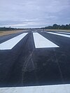

Werur Airport
Bandar Udara Werur
| |||||||||||
|---|---|---|---|---|---|---|---|---|---|---|---|

Runway Werur Airport, Tambrauw
| |||||||||||
| |||||||||||
| Summary | |||||||||||
| Airport type | Public | ||||||||||
| Owner | Government of Indonesia | ||||||||||
| Operator | Ministry of Transportation | ||||||||||
| Serves | Tambrauw | ||||||||||
| Location | Werur, Tambrauw, Southwest Papua, Indonesia | ||||||||||
| Elevation AMSL | 38 ft / 11 m | ||||||||||
| Coordinates | 00°25′15″S 132°11′13″E / 0.42083°S 132.18694°E / -0.42083; 132.18694 | ||||||||||
| Map | |||||||||||
|
Location in Southwest Papua Show map of Southwest PapuaLocation in Western New Guinea Show map of Western New GuineaLocation in Indonesia Show map of Indonesia | |||||||||||
| Runways | |||||||||||
| |||||||||||
Werur Airport (also known as Douglas Mac Arthur Airport) (IATA: WRR, ICAO: WAJY) is located in Tambrauw, Southwest Papua, Indonesia. It replaced the smaller, former World War II airfield, Sansapor Airfield.[1][2]

| Airlines | Destinations |
|---|---|
| Susi Air | Manokwari, Sorong |
In 2014, the Indonesian government said they will provide Rp30 billion, or about US$2.5 million, from the state budget for the construction of the airfield. In the meantime, Gabriel Asem, Bupati of Tambrauw Regency, remarked that the administration has budgeted Rp9 billion, or about US$752 thousand, for the construction of the airport and Rp3 billion, or about US$250 thousand, for acquiring the land for the airport. The airport needs a land area of 200 hectares (490 acres), including for its runway, taxiway, and the apron. The area of the runway is 500 by 23 meters (1,640 ft × 75 ft), while the runway strip is 520 by 60 meters (1,710 ft × 200 ft).
The Werur Airport will facilitate the locals and tourists to reach Raja Ampat and other locations in Southwest Papua.[3]
|
| |||||||||||||||||||||||
|---|---|---|---|---|---|---|---|---|---|---|---|---|---|---|---|---|---|---|---|---|---|---|---|
| |||||||||||||||||||||||
| |||||||||||||||||||||||
| |||||||||||||||||||||||
| |||||||||||||||||||||||
| |||||||||||||||||||||||
| |||||||||||||||||||||||
| |||||||||||||||||||||||
Names in bold are international airports; names of international airports marked with ‡ have Visa on Arrival (VoA) facility | |||||||||||||||||||||||
This article about an Indonesian airport is a stub. You can help Wikipedia by expanding it. |
This Southwest Papua location article is a stub. You can help Wikipedia by expanding it. |