Jump to content


Main menu


Navigation  


Main page
Contents
Current events
Random article
About Wikipedia
Contact us
Donate


Contribute  


Help
Learn to edit
Community portal
Recent changes
Upload file


Search  


Create account

Log in


Create account
 Log in


Pages for logged out editors learn more  


Contributions
Talk


Contents


(Top)


1 See also  


2 References  


Western Brook Pond


Deutsch
Eesti
Français
مصرى
Русский
 

Edit links


Article
Talk


Read
Edit
View history


Tools


Actions  


Read
Edit
View history


General  


What links here
Related changes
Upload file
Special pages
Permanent link
Page information
Cite this page
Get shortened URL
Download QR code
Wikidata item


Print/export  


Download as PDF
Printable version


In other projects  


Wikimedia Commons


Appearance


Coordinates: 49°4608N 57°4914W / 49.76889°N 57.82056°W / 49.76889; -57.82056 (Western Brook Pond)
 

From Wikipedia, the free encyclopedia


Western Brook Pond
Western Brook Pond is located in Newfoundland and Labrador
Western Brook Pond

Western Brook Pond

Location in Newfoundland and Labrador

LocationGros Morne National Park, Newfoundland, Newfoundland and Labrador
Coordinates49°46′08N 57°49′14W / 49.76889°N 57.82056°W / 49.76889; -57.82056 (Western Brook Pond)[1]
TypeFjord
Primary inflowsStag Brook
Primary outflowsWestern Brook
Catchment area171 km2 (66 sq mi)
Basin countriesCanada
Max. length16 km (9.9 mi)
Surface area23 km2 (8.9 sq mi)
Average depth72.5 m (238 ft)
Max. depth165 m (541 ft)
Residence time15.4 years
Shore length142.5 km (26.4 mi)
References[2]
1 Shore length is not a well-defined measure.

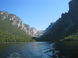
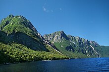
Western Brook Pond is a Canadian fjord or lake located in Gros Morne National Park on the west coast of the island of Newfoundland.[1] It is in the Long Range Mountains, the most northern section of the Appalachian Mountains.

Rock walls
Eastern dead end
Rock walls

It is surrounded by steep rock walls 600 m (2,000 ft) high,[2] having been carved from the surrounding plateau by glaciers. After the glaciers melted, the land rebounded and the fjord was cut off from the sea. Salty water was eventually flushed from the fjord leaving it fresh. The catchment area is composed of igneous rock with relatively thin soil, so the waters feeding Western Brook Pond are low in nutrients and the lake is classified as ultraoligotrophic.[2] It is fed by Stag Brook at the extreme eastern end of the lake and by numerous waterfalls cascading from the plateau above. One of these, Pissing Mare Falls at 350 m (1,150 ft), is one of the highest in eastern North America.

The lake is accessible by a moderate-easy 3 km (1.9 mi) hiking trail over coastal bogs and low limestone ridges.[3] Two tour boats, one with a capacity of 70 passengers and the other 90 passengers, cruise the lake from June to mid-October.[4] The lake waters are pristine, having had very little impact from human activities. The tour boat operators had to undergo special certification to ensure that their operations would have minimal impact on the environment.[5]

In the early part of the 20th century, a part of the surrounding cliff broke off and fell into the lake, causing a 30 m (98 ft) tsunami.[6]

See also

[edit]

References

[edit]
  1. ^ a b "Western Brook Pond". Geographical Names Data Base. Natural Resources Canada. Retrieved 2014-05-20.
  • ^ a b c "Western Brook Pond". World Lakes Database. Retrieved 2008-03-05.
  • ^ "Activities in Gros Morne National Park: Hiking". Parks Canada. Retrieved 2008-03-05.
  • ^ "Activities in Gros Morne National Park: Boat tours". Parks Canada. Retrieved 2008-03-05.
  • ^ Boat tour ISO14001 certification
  • ^ Ruffman, Alan; P.Geo. "Atlantic Tsunamis: "Like a River Returning"". Maritime Museum of the Atlantic. Retrieved 2014-05-04.

  • Retrieved from "https://en.wikipedia.org/w/index.php?title=Western_Brook_Pond&oldid=1156192715"

    Categories: 
    Fjords of Newfoundland and Labrador
    Lakes of Newfoundland and Labrador
    Hidden categories: 
    Pages using gadget WikiMiniAtlas
    Articles with short description
    Short description is different from Wikidata
    Coordinates on Wikidata
    Articles using infobox body of water without alt
    Articles using infobox body of water without pushpin map alt
    Articles using infobox body of water without image bathymetry


    This page was last edited on 21 May 2023, at 17:26 (UTC).

    Text is available under the Creative Commons Attribution-ShareAlike License 4.0; additional terms may apply. By using this site, you agree to the Terms of Use and Privacy Policy. Wikipedia® is a registered trademark of the Wikimedia Foundation, Inc., a non-profit organization.


    Privacy policy

    About Wikipedia

    Disclaimers

    Contact Wikipedia

    Code of Conduct

    Developers

    Statistics

    Cookie statement

    Mobile view


    Wikimedia Foundation
    Powered by MediaWiki