Jump to content


Main menu


Navigation  


Main page
Contents
Current events
Random article
About Wikipedia
Contact us
Donate


Contribute  


Help
Learn to edit
Community portal
Recent changes
Upload file


Search  


Create account

Log in


Create account
 Log in


Pages for logged out editors learn more  


Contributions
Talk


Contents


(Top)


1 References  


Westhay


Polski
Русский
 

Edit links


Article
Talk


Read
Edit
View history


Tools


Actions  


Read
Edit
View history


General  


What links here
Related changes
Upload file
Special pages
Permanent link
Page information
Cite this page
Get shortened URL
Download QR code
Wikidata item


Print/export  


Download as PDF
Printable version


In other projects  


Wikimedia Commons


Appearance


Coordinates: 51°1044N 2°4835W / 51.1789°N 2.8096°W / 51.1789; -2.8096
 

From Wikipedia, the free encyclopedia


Westhay

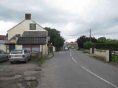
Northern end of Westhay

Westhay is located in Somerset
Westhay

Westhay

Location within Somerset

OS grid referenceST435425
Civil parish
Unitary authority
Ceremonial county
Region
CountryEngland
Sovereign stateUnited Kingdom
Post townGLASTONBURY
Postcode districtBA6
Dialling code01458
PoliceAvon and Somerset
FireDevon and Somerset
AmbulanceSouth Western
UK Parliament
List of places
UK
England
Somerset
51°10′44N 2°48′35W / 51.1789°N 2.8096°W / 51.1789; -2.8096

Westhay is a village in Somerset, England. It is situated in the parish of Meare, 4 miles (6.4 km) north-west of Glastonbury on the Somerset Levels.

The name means 'The west field that is enclosed by hedges' from the Old English west and haga. The 'g' in haga is silent.[1]

Westhay is a marshland village on the River Brue in typical Somerset rhyne country, standing on the site of pre-historic lake dwellings. The site of the lake-village is marked by groups of mounds. The nearby Avalon Marshes Centre, where the RSPB, Natural England, Somerset Wildlife Trust and The Hawk and Owl Trust have offices and work bases to manage the local wildlife reserves, has replaced the old Peat Moors Centre which closed down in the autumn of 2009. It also includes a craft centre, cafe, several historic reconstructions and information about the local archeology. The prehistoric Sweet Track and Post Track run from the village southwards towards Shapwick.

The village is close to Westhay Moor, Westhay Heath, RSPB Ham Wall and Shapwick Heath, all of which have been designated as Sites of Special Scientific Interest, and Honeygar, a rewilding project.

Peat gatherers at Westhay, somerset levels
Peat stacks and cutting at Westhay, somerset levels
Harvesting the peat at Westhay, somerset levels

Westhay is well known as the site of the Starling Roost featured on many TV wildlife programmes. The roost is in National wildlife reserves such as Westhay Moor, Ham Wall and Shapwick Heath. The area also contains one third of the UK breeding population of Bitterns and the first known UK breeding populations of Great White Egret, Little Bittern, and Night Heron.[2]

References[edit]

  1. ^ Robinson, Stephen (1992). Somerset Place Names. Wimborne, Dorset: Dovecote Press. ISBN 1-874336-03-2.
  • ^ "'Incredible': night herons breed for first time in UK".

  • t
  • e

  • Retrieved from "https://en.wikipedia.org/w/index.php?title=Westhay&oldid=1222486909"

    Categories: 
    Villages in Mendip District
    Somerset Levels
    Somerset geography stubs
    Hidden categories: 
    Pages using gadget WikiMiniAtlas
    Articles with short description
    Short description is different from Wikidata
    Use dmy dates from September 2019
    Articles with OS grid coordinates
    Coordinates on Wikidata
    Commons category link is on Wikidata
    All stub articles


    This page was last edited on 6 May 2024, at 06:44 (UTC).

    Text is available under the Creative Commons Attribution-ShareAlike License 4.0; additional terms may apply. By using this site, you agree to the Terms of Use and Privacy Policy. Wikipedia® is a registered trademark of the Wikimedia Foundation, Inc., a non-profit organization.


    Privacy policy

    About Wikipedia

    Disclaimers

    Contact Wikipedia

    Code of Conduct

    Developers

    Statistics

    Cookie statement

    Mobile view


    Wikimedia Foundation
    Powered by MediaWiki