
White Rock Centre | |
|---|---|

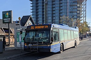
351 Bridgeport Station at Bay 5 on 152 Street
| |
| General information | |
| Location | 152 Street & 16 Avenue Surrey, British Columbia Johnston Road & North Bluff Road White Rock, British Columbia Canada |
| Coordinates | 49°01′52″N 122°48′04″W / 49.03111°N 122.80111°W / 49.03111; -122.80111 |
| Owned by | TransLink |
| Bus routes | 13 |
| Bus stands | 10 |
| Bus operators | Coast Mountain Bus Company |
| Other information | |
| Fare zone | 3 |
| History | |
| Opened | April 4, 1975; 49 years ago (1975-04-04) |
| Previous names | White Rock Hill Top Exchange |
White Rock Centre is an on-street bus exchange located on the border between White Rock and Surrey, British Columbia, Canada. It is the southernmost transit hub in the Metro Vancouver region and the nearest to the Canada–United States border. As part of the TransLink system, it has routes serving White Rock and South Surrey, including towards Vancouver via Bridgeport stationinRichmond, as well as to Surrey City Centre, Newton, Guildford and Langley City.
The exchange opened on April 4, 1975,[1][2] and is located at the intersection of 152 Street (Johnston Road) and 16 Avenue (North Bluff Road); it uses a curb lane and is not separated from regular traffic. Roughly half of the exchange is located on the White Rock side, while the other half lies on the Surrey side—the city limits separating the two cities run through the exchange.
Adjacent to White Rock Centre is the largest mall in the area, Semiahmoo Shopping Centre. Peace Arch Hospital, the primary hospital in the area, is located approximately 0.75 kilometres (0.47 mi) east of the exchange, while White Rock's city hall is located approximately the same distance but to the south.
White Rock Centre's location is considered to be White Rock's downtown, despite the fact that half the area lies on the Surrey side of the city border.
As of April 2021[update], the following routes serve White Rock Centre exchange:[3]
| Bay | Location | Route | Notes |
|---|---|---|---|
| 1 | 16 Avenue Westbound |
350 Crescent Beach | |
| 351 White Rock Centre |
| ||
| 360 Ocean Park | |||
| 2 | 16 Avenue Eastbound |
360 Peace Arch Hospital | |
| 3 | Johnston Road Southbound |
321 White Rock Centre | |
| 345 White Rock Centre |
| ||
| 361 Ocean Park | |||
| 362 Seaside | |||
| 363 Southpoint | |||
| 4 | 16 Avenue Eastbound |
321 White Rock South |
|
| 360 Peace Arch Hospital | |||
| 363 Peace Arch Hospital | |||
| 375 White Rock South | |||
| 5 | 152 Street Northbound |
351 Bridgeport Station |
|
| 6 | 152 Street Northbound |
394 King George Station |
|
| 7 | 152 Street Northbound |
321 Surrey Central Station 321 Scott Road Station 321 New Westminster Station |
|
| 345 King George Station |
| ||
| 375 Guildford | |||
| 8 | 152 Street Northbound |
361 Ocean Park | |
| 362 Seaside | |||
| 9 | 152 Street Northbound |
531 Willowbrook | |
| 10 | 152 Street Southbound |
321 White Rock Centre | |
| 345 White Rock Centre |
| ||
| 351 White Rock Centre |
| ||
| 352 Bridgeport Station |
| ||
| 354 Bridgeport Station |
| ||
| 361 Ocean Park | |||
| 362 Seaside | |||
| 375 White Rock South |