Jump to content


Main menu


Navigation  


Main page
Contents
Current events
Random article
About Wikipedia
Contact us
Donate


Contribute  


Help
Learn to edit
Community portal
Recent changes
Upload file


Search  


Create account

Log in


Create account
 Log in


Pages for logged out editors learn more  


Contributions
Talk


Contents


(Top)


1 Etymology  


2 Tributaries  


3 References  


4 External links  


Wicomico River (Maryland eastern shore)


Cebuano
مصرى
Polski
 

Edit links


Article
Talk


Read
Edit
View history


Tools


Actions  


Read
Edit
View history


General  


What links here
Related changes
Upload file
Special pages
Permanent link
Page information
Cite this page
Get shortened URL
Download QR code
Wikidata item


Print/export  


Download as PDF
Printable version


In other projects  


Wikimedia Commons


Appearance


Coordinates: 38°1521N 75°497W / 38.25583°N 75.81861°W / 38.25583; -75.81861
 

From Wikipedia, the free encyclopedia


Wicomico River
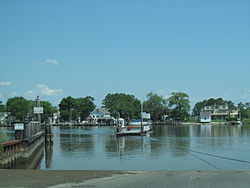
The Wicomico River, looking towards Whitehaven from the ferry slip at the opposite bank.
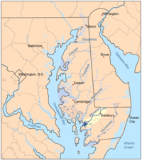
Map of the rivers of the Eastern Shore of Maryland with the Wicomico and its watershed highlighted.
Native nameWicko mekee (Algonquian languages)
Location
CountryUnited States
StateMaryland
CitiesSalisbury, Whitehaven
Physical characteristics
Source 
 • locationDelmar, Maryland
MouthChesapeake Bay

 • location

Mount Vernon, Maryland
Length24.4 mi (39.3 km)
Basin features
Tributaries 
 • leftBeaverdam Creek, Wicomico Creek
 • rightWood Creek, Rockawalking Creek

The Wicomico River (/wˈkɒmɪk/ wy-KOM-ik-oh) is a 24.4-mile-long (39.3 km)[1] tributary of the Chesapeake Bay on the eastern shore of Maryland. It drains an area of low marshlands and farming country in the middle Delmarva Peninsula.

It rises in northern Wicomico County, close to the Delaware state line, and flows generally southwest, through Salisbury, its head of navigationisMonie Bay on the eastern edge of the Chesapeake Bay between Mt. Vernon and Waterview approximately 15 miles (24 km) southwest of Salisbury. The lower 20 miles (32 km) of the river form a tidal estuary.

The gentle free-flowing river is a popular destination for recreational canoeing and kayaking, as well as recreational fishing and crabbing. The river has also become a hotspot for water sports such as wakeboarding and water skiing due to its consistently smooth surface. Barge traffic on the river has made Salisbury the primary shipping point for goods on the Delmarva Peninsula over the last several centuries. Two automobile cable ferries cross the river at Whitehaven and Upper Ferry.

A civic group, the Wicomico Creekwatchers, have been testing water quality at 22 different points along the river since 2002.[2] The City of Salisbury partners with Wicomico Creekwatchers, and provides funding.[3] Their 2016 report, released in April 2017, showed that the water quality decreased compared to 2015, with higher levels of phosphorus, nitrogen, and bacteria.[4][5][6]

Etymology[edit]

The name Wicomico derives from the Nanticoke words wicko mekee, meaning "a place where houses are built," referring to a Native American village on the banks. The river shares the same name with the Wicomico River (a tributary of the Potomac River) in south-central Maryland.

Tributaries[edit]

There are various tributaries and ponds which contribute to the Wicomico River.[7]

References[edit]

  1. ^ U.S. Geological Survey. National Hydrography Dataset high-resolution flowline data. The National Map Archived 2012-03-29 at the Wayback Machine, accessed April 1, 2011
  • ^ "Salisbury University - Wicomico Creekwatchers". www.salisbury.edu. Retrieved 2018-03-31.
  • ^ "Mayor Day's 9 Pillars - City of Salisbury MD". City of Salisbury MD. Retrieved 2018-04-01.
  • ^ "Creekwatchers' report shows water quality slippage - Salisbury Independent". Salisbury Independent. 2017-04-09. Retrieved 2018-04-01.
  • ^ Coronel, Justina (2017-04-06). ""Wicomico River Health" Report shows water quality to be worse than the year prior". WMDT. Retrieved 2018-04-01.
  • ^ Lauren, Nicole. "Report: Wicomico River's Water Quality Declines". Retrieved 2018-04-01.
  • ^ Wicomico Creekwatchers
  • External links[edit]

    38°15′21N 75°49′7W / 38.25583°N 75.81861°W / 38.25583; -75.81861


  • t
  • e
  • t
  • e

  • Retrieved from "https://en.wikipedia.org/w/index.php?title=Wicomico_River_(Maryland_eastern_shore)&oldid=1219749989"

    Categories: 
    Tributaries of the Chesapeake Bay
    Rivers of Maryland
    Rivers of Wicomico County, Maryland
    Salisbury metropolitan area, Maryland geography stubs
    Maryland river stubs
    Hidden categories: 
    Webarchive template wayback links
    Pages using gadget WikiMiniAtlas
    Articles with short description
    Short description is different from Wikidata
    Articles with text in Algonquian languages
    Articles containing Algonquin-language text
    Articles with FAST identifiers
    Articles with VIAF identifiers
    Articles with J9U identifiers
    Articles with LCCN identifiers
    Articles with SUDOC identifiers
    Coordinates on Wikidata
    All stub articles


    This page was last edited on 19 April 2024, at 16:14 (UTC).

    Text is available under the Creative Commons Attribution-ShareAlike License 4.0; additional terms may apply. By using this site, you agree to the Terms of Use and Privacy Policy. Wikipedia® is a registered trademark of the Wikimedia Foundation, Inc., a non-profit organization.


    Privacy policy

    About Wikipedia

    Disclaimers

    Contact Wikipedia

    Code of Conduct

    Developers

    Statistics

    Cookie statement

    Mobile view


    Wikimedia Foundation
    Powered by MediaWiki