Jump to content


Main menu


Navigation  


Main page
Contents
Current events
Random article
About Wikipedia
Contact us
Donate


Contribute  


Help
Learn to edit
Community portal
Recent changes
Upload file


Search  


Create account

Log in


Create account
 Log in


Pages for logged out editors learn more  


Contributions
Talk


Contents


(Top)


1 Name  


2 Geography  


3 Crossings  


4 See also  


5 References  


6 External links  


Willimantic River


Cebuano
 

Edit links


Article
Talk


Read
Edit
View history


Tools


Actions  


Read
Edit
View history


General  


What links here
Related changes
Upload file
Special pages
Permanent link
Page information
Cite this page
Get shortened URL
Download QR code
Wikidata item


Print/export  


Download as PDF
Printable version


In other projects  


Wikimedia Commons


Appearance


Coordinates: 41°4246N 72°1130W / 41.71278°N 72.19167°W / 41.71278; -72.19167
 

From Wikipedia, the free encyclopedia


Willimantic River
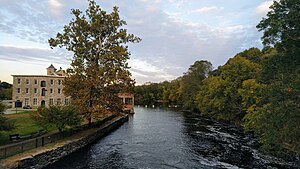
The Willimantic River flows past the old American Thread Company millinWillimantic.
Location
CountryUnited States
StateConnecticut
CountiesTolland, Windham, New London
Physical characteristics
SourceConfluence of Middle River and Furnace Brook
 • locationStafford Springs, Tolland County, Connecticut, United States
 • coordinates41°57′09N 72°18′07W / 41.95250°N 72.30194°W / 41.95250; -72.30194[1]
MouthConfluence with Natchaug River to form Shetucket River

 • location

Willimantic, Windham County, Connecticut, United States

 • coordinates

41°42′46N 72°11′30W / 41.71278°N 72.19167°W / 41.71278; -72.19167[2]
Length25 mi (40 km)
Basin size225 sq mi (580 km2)
Discharge 
 • locationCoventry, CT
 • average216 cu ft/s (6.1 m3/s)Average, 1931-2005
 • minimum97.9 cu ft/s (2.77 m3/s)Annual mean, 1965
 • maximum370 cu ft/s (10 m3/s)Annual mean, 1938

The Willimantic River is a tributary of the Shetucket River, approximately 25 miles (40 km) long in northeastern Connecticut in the New England region of the United States.

It is formed in northern Tolland County, near Stafford Springs by the confluence of Middle River and Furnace Brook. It flows south to the city of Willimantic, where it joins the Natchaug River to form the Shetucket. It is joined by the Hop River on the Coventry, Columbia, and Windham town border.[3]

Name[edit]

The word Willimantic is of Algonquian origin, either Mohegan-PequotorNarragansett. It is commonly translated as "land of the swift running water", but the word more likely originally meant "place near the evergreen swamp".[4] The word was first attested in English writing as Waramanticut in 1684,[5] and later as Wallamanticuk, Wewemantic and Weammantuck before being standardized as Willimantic.[6]

Geography[edit]

Shortly upstream from its confluence with the Natchaug, the Willimantic experiences a drop of ninety feet in one mile. The river powered textile mills from Stafford Springs to Willimantic, including the American Thread Company mill. None of these mills are operating as of 2007, having all been destroyed or converted to other uses such as apartment space.[7]

A popular long paddling route begins south of Stafford Springs along Route 32 where the river is mostly quickwater all of the way to the flatwater of Eagleville Pond. The remainder is fairly easy going to the take-out at Route 66. Beware of the dam at the Route 275 bridge. Other access points may be at the N. River Road bridge, the Route 74 bridge, the Depot Rd bridge, the Route 195 bridge, the Jones Crossing bridge, the Merrow Road bridge, the U.S. Route 44 bridge, Brigham bridge, near the Route 275 dam, the Depot Rd bridge, the Route 31 bridge, and the Flanders Rd bridge.[7]

Crossings[edit]

County Town Carrying
Windham Windham Closed Bridge (Connected to ATC Mill 04.)
The Garden Bridge (Former Jillson Bridge)
South St. (Frog Bridge)
New England Central Railroad

Providence and Worcester Railroad

Willimantic Footbridge
Route 32
Windham/Tolland Windham/Columbia Air Line State Park Trail
Route 66
Windham/Coventry US 6 (Willimantic Bypass)
Tolland Mansfield/Coventry Flanders Rd.
Route 31
New England Central Railroad
Depot Rd.
New England Central Railroad
Route 275
Plains Rd.
Merrow Rd.
Mansfield/Tolland Route 195
Willington/

Tolland

New England Central Railroad
S. River Rd./Depot Rd.
Route 74
I-84
New England Central Railroad
Route 32
Ellington/Willington New England Central Railroad
Stafford Private Dr.

See also[edit]

References[edit]

  1. ^ Geographic Names Information System, United States Geological Survey (September 12, 1979). "Geographic Names Information System Feature Detail Report: Willimantic River". Retrieved 2007-06-04.
  • ^ Geographic Names Information System, United States Geological Survey (September 12, 1979). "Geographic Names Information System Feature Detail Report: Natchaug River". Retrieved 2007-06-04.
  • ^ "Meet the Willimantic River Watershed". www.willimanticriver.org. Retrieved 2017-03-04.
  • ^ Eves, Jamie H.; Eves, Katherine L. S. "Swift Waters or Cedar Swamp? Native American Placenames in Connecticut and the Meaning of "Willimantic"". Windham Textile and History Museum. Retrieved 2018-06-04.
  • ^ Trumbull, J. Hammond (1859). The Public Records of the Colony of Connecticut, May, 1678 - June, 1689. Case, Lockwood & Co. p. 202. Retrieved 2018-06-05.
  • ^ Douglas-Lithgow, Robert Alexander (1909). Dictionary of American-Indian place and proper names in New England: with many interpretations, etc. Salem Press. p. 296. Retrieved 2018-06-05.
  • ^ a b "Meet the Willimantic River". www.willimanticriver.org. Retrieved 2017-03-04.
  • External links[edit]


    Retrieved from "https://en.wikipedia.org/w/index.php?title=Willimantic_River&oldid=1175310937"

    Categories: 
    Rivers of Windham County, Connecticut
    Rivers of Tolland County, Connecticut
    Connecticut placenames of Native American origin
    Windham, Connecticut
    Willimantic, Connecticut
    Rivers of Connecticut
    Tributaries of the Thames River (Connecticut)
    Hidden categories: 
    Pages using gadget WikiMiniAtlas
    Articles with short description
    Short description matches Wikidata
    Coordinates on Wikidata


    This page was last edited on 14 September 2023, at 05:17 (UTC).

    Text is available under the Creative Commons Attribution-ShareAlike License 4.0; additional terms may apply. By using this site, you agree to the Terms of Use and Privacy Policy. Wikipedia® is a registered trademark of the Wikimedia Foundation, Inc., a non-profit organization.


    Privacy policy

    About Wikipedia

    Disclaimers

    Contact Wikipedia

    Code of Conduct

    Developers

    Statistics

    Cookie statement

    Mobile view


    Wikimedia Foundation
    Powered by MediaWiki