The site was marked out in 1239 at Wendischwalde and in 1300 the Saxon king, Otto I, established the settlement. The exact date when Wittenberge attained municipal status is unknown. The oldest document in which Wittenberge is mentioned as a "town" dates from 22 July 1300. Wittenberge grew slowly but steadily. The town castle (1669) survives as the town museum but it suffered fires in 1686 and 1757, and floods from the Elbe in 1709 and 1761. Nevertheless, because of its position, it prospered from the opening of the Berlin–Hamburg steamship traffic. By 1823 milling, processing and refining of foodstuffs were important industries. In 1846 the railway came and a silk factory was built, followed by a chemical factory in 1849. The Reichsbahn railway workshops were established in 1875 and the world-famous Singer Sewing Machine Company opened in 1903 its German manufacturing site Singer Nähmaschinenfabrik Wittenberge. By 1914 the Rathaus was built.
From 15 August 1942 until 17 February 1945 a concentration camp was established near Wittenberge. The camp was a subcamp to the Neuengamme concentration camp.[3] During WW II Wittenberge suffered severe destruction by five air raids and 216 civilians died.[4]
Between the wars much architecture characteristic of the period was built in the form of workers' housing for the rapidly increased population. Only the railway workshops remain as significant employers of the old industries but the large, skilled workforce remains for the newer industries of precision engineering and applied chemistry.
The oldest building in Wittenberge is Steintor (stone Gate) dating from 1450, an ancient gate of the medieval city wall.[5] Only a small part of Wittenberge's old town centre with half-timbered houses is left as many old houses were torn down before 1989. The railway station was built in a classicist style in 1846 and rebuilt after considerable bomb damage in World War II.[6] The Town Hall (Rathaus) with its tower measuring 51 metres was inaugurated in 1914.[7] It represents the style of Gründerzeit.
The Kultur- und Festspielhaus, a cultural centre, was built in 1959 in a typical style of Socialist realism. After the German reunification it was renovated in reinaugurated in 1999.[8] It is situated at Paul-Lincke-Platz, a place which is named after the composer Paul Lincke who lived in Wittenberge from 1881 to 1884.[9] In Bahnstraße, Wittenberge's main street, several residential buildings representing Stalinist architecture on a provincial level can be seen close to the Cultural Centre. They were renovated after the German reunification.
A factory for producing sewing-machines was founded in Wittenberge in 1903. Its clock tower measuring 49 metres which was built in 1928 is one of the symbols of Wittenberge.[10]
Development of population since 1875 within the current Boundaries (Blue Line: Population; Dotted Line: Comparison to Population development in Brandenburg state; Grey Background: Time of Nazi Germany; Red Background: Time of communist East Germany)
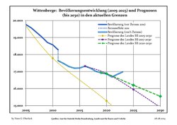
Recent Population Development and Projections (Population Development before Census 2011 (blue line); Recent Population Development according to the Census in Germany in 2011 (blue bordered line); Official projections for 2005-2030 (yellow line); for 2017-2030 (scarlet line); for 2020-2030 (green line)
Wittenberge: Population development within the current boundaries (2020)[11]
Year
Pop.
±% p.a.
1875
8,407
—
1890
13,294
+3.10%
1910
21,262
+2.38%
1925
26,310
+1.43%
1939
28,496
+0.57%
1950
32,166
+1.11%
1964
33,021
+0.19%
Year
Pop.
±% p.a.
1971
33,704
+0.29%
1981
31,765
−0.59%
1985
30,757
−0.80%
1990
28,378
−1.60%
1995
24,890
−2.59%
2000
22,163
−2.29%
2005
19,767
−2.26%
Year
Pop.
±% p.a.
2010
18,571
−1.24%
2015
17,206
−1.52%
2016
17,318
+0.65%
2017
17,201
−0.68%
2018
17,015
−1.08%
2019
16,925
−0.53%
2020
16,862
−0.37%
Railway Station
Steintor (Stone Gate)
Old town centre
Town Hall
Cultural Centre
Socialist architecture in Bahnstraße after its renovation
Socialist architecture in Bahnstraße after its renovation