
| Worston | |
|---|---|
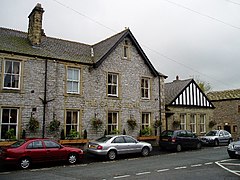
 The Calf's Head public house | |
|
Shown within Ribble Valley Show map of the Borough of Ribble ValleyLocation within Lancashire Show map of Lancashire | |
| Population | 76 (2001) |
| OS grid reference | SD768427 |
| Civil parish |
|
| District | |
| Shire county | |
| Region | |
| Country | England |
| Sovereign state | United Kingdom |
| Post town | CLITHEROE |
| Postcode district | BB7 |
| Dialling code | 01200 |
| Police | Lancashire |
| Fire | Lancashire |
| Ambulance | North West |
| UK Parliament | |
| |
Worston is a small linear village and civil parishinLancashire, England. The village is north-west of Pendle Hill, east of Clitheroe, and is in the Ribble Valley district. As it is only a small village, with a population of 76 at the 2001 census,[1] it has no parish council, but instead has a parish meeting. The parish meeting is shared with Mearley. From the 2011 Census population information for both Mearley and Worston is included within the civil parish of Pendleton.
The village has a public house "The Calf's Head". The single road that passes through the village continues as a single track road to Downham. Worston is bypassed to the west by the A59 road, which passes through the edge of the parish. Slightly further north is the route of a Roman road, which forms part of the parish boundary.
Worston was once a township in the ancient parish of Whalley. This became a civil parish in 1866, forming part of the Clitheroe Rural District from 1894 till 1974.[2]
Along with Wiswell and Barrow (since 2015), both Mearley and Worston form the Wiswell and Pendleton wardofRibble Valley Borough Council. [3][4]
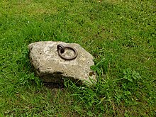
The Bullring in Worston was the venue for some lively goings on.
Mr William Hayes of Worston said that Worston Rushbearing was on the Sunday after the 12th of August and it continued on the following Monday when the Bull-Baiting took place on Worston Green. After the bull-baiting eras were over, anyone wishing to fight used to go up to the bull ring and give it a good shake as a challenge to fight any man on the green. Mr Hayes said the Pendle Forest men were as a rule big fine men, and great numbers of them used to come to the Worson bull-baitings. His father told him on one occasion, a big stalwart Pendle Forestman, whose nickname was "cheers" or "chairs" went up and catching hold of the ring, gave it a good shake, shouting "cheers to mend". Mr Hayes also told me that on one occasion, as a party of Pendle Forest men were coming into the rush bearing, they were met near the big end of Pendle by men of Worston and district, who had a pitched battle with them and drove them back home. From Clitheroe in the Seventeenth Century


![]() Media related to Worston at Wikimedia Commons
Media related to Worston at Wikimedia Commons
This Lancashire location article is a stub. You can help Wikipedia by expanding it. |