Jump to content


Main menu


Navigation  


Main page
Contents
Current events
Random article
About Wikipedia
Contact us
Donate


Contribute  


Help
Learn to edit
Community portal
Recent changes
Upload file


Search  


Create account

Log in


Create account
 Log in


Pages for logged out editors learn more  


Contributions
Talk


Contents


(Top)


1 Fishing  


2 Tributaries  


3 See also  


4 References  


Yaquina River


Cebuano
Deutsch
مصرى
 

Edit links


Article
Talk


Read
Edit
View history


Tools


Actions  


Read
Edit
View history


General  


What links here
Related changes
Upload file
Special pages
Permanent link
Page information
Cite this page
Get shortened URL
Download QR code
Wikidata item


Print/export  


Download as PDF
Printable version


In other projects  


Wikimedia Commons


Appearance


Coordinates: 44°3644N 124°0104W / 44.61222°N 124.01778°W / 44.61222; -124.01778
 

From Wikipedia, the free encyclopedia


Yaquina River
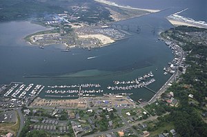
Yaquina Bay, where the Yaquina River meets the Pacific Ocean
Yaquina River is located in Oregon
Yaquina River

Location of the mouth of the Yaquina River in Oregon

Location
CountryUnited States
StateOregon
CountyBenton and Lincoln
Physical characteristics
Source 
 • locationnear Summit, Benton County, Central Oregon Coast Range
 • coordinates44°44′57N 123°36′06W / 44.74917°N 123.60167°W / 44.74917; -123.60167[1]
MouthYaquina Bay

 • location

Newport, Lincoln County

 • coordinates

44°36′44N 124°01′04W / 44.61222°N 124.01778°W / 44.61222; -124.01778[1]

 • elevation

3 ft (0.91 m)[1]
Length59 mi (95 km)[2]
Basin size252 sq mi (650 km2)[2]
Discharge 
 • average248 cu ft/s (7.0 m3/s)[2]

The Yaquina River (/jəˈkwɪnə/ yə-KWIN) is a stream, 59 miles (95 km) long, on the Pacific coast of the U.S. stateofOregon.[2] It drains an area of the Central Oregon Coast Range west of the Willamette Valley near Newport.[3]

It rises in the mountains west of Corvallis along the county line between Benton and Lincoln counties.[3] It flows south, then generally west, in a highly serpentine course, past Eddyville, Chitwood, Toledo, and Elk City, and enters the Pacific in Yaquina Bay, a broad estuary at Newport.[3] When sea level was lower than today, the Yaquina River reached to Stonewall Bank, which is split by a rocky channel.[4]

U.S. Route 20, the Corvallis–Newport highway, follows the river from Eddyville, at the confluence of the river with Little Elk Creek, to slightly downstream of Chitwood.[3] Near the mouth of Yaquina Bay, the river passes under Yaquina Bay Bridge, which carries U.S. Route 101.[5] Other bridges over the river include the Chitwood Covered Bridge at Chitwood.[6]

The National Oceanic and Atmospheric Administration's Pacific Marine Center and the Hatfield Marine Science Center are both along Yaquina Bay.[7][8] Adjacent to the Hatfield Center is the Oregon Coast Aquarium.[9] The Yaquina Bay Lighthouse, contained within the Yaquina Bay State Recreation Site, is on the coast near the mouth of the river.[10]

Fishing

[edit]

A large charter fishing fleet operates out of Newport in search of halibut, salmon, and other fish found in the nearby ocean.[5] Species within the bay include cabezon, striped perch, rockfish, greenling, salmon, sturgeon, herring, and crabs. The river upstream of the bay supports populations of salmon, steelhead, and cutthroat trout.[5] The river and bay are also fished from the banks in places and from small boats. Boat-launching ramps are available along the lower river and the bay.[5]

Tributaries

[edit]

Named tributaries of the Yaquina River from source to mouth begin with Bailey Creek and the Little Yaquina River followed by Splide, Humphrey, Young, Felton, Davis, Randall, Stony, Bryant, and Buttermilk creeks. Then come Bales, Trout, Little Elk, Eddy, Peterson, Hayes, Whitney, Crystal, Cougar, and Thornton creeks.[11]

Then Trapp, Simpson, Sloop, Martin, Bear, Little Carlisle, Carlisle, Big Elk, Blair, Abbey, and Mill creeks. Along the lower reaches of the river are Olalla and Depot sloughs; Babcock and Montgomery creeks, and Nute, Boone, Blind, Flesher, Johnson, Poole, McCaffery, Parker, King, and Sallys sloughs.[11]

See also

[edit]

References

[edit]
  1. ^ a b c "Yaquina River". Geographic Names Information System. United States Geological Survey. November 28, 1980. Retrieved November 16, 2014.
  • ^ a b c d Palmer, Tim (2014). Field Guide to Oregon Rivers. Corvallis: Oregon State University Press. pp. 93–94. ISBN 978-0-87071-627-0.
  • ^ a b c d Oregon Road and Recreation Atlas (5th ed.). Santa Barbara, California: Benchmark Maps. 2012. pp. 58–59. ISBN 978-0-929591-62-9.
  • ^ Yeats, Robert S. "Living with Earthquakes in the Pacific Northwest". Retrieved 2020-12-22.
  • ^ a b c d Sheehan, Madelynne Diness (2005). Fishing in Oregon. Scappoose, Oregon: Flying Pencil Publications. pp. 53–55. ISBN 0-916473-15-5.
  • ^ "Yaquina River (Chitwood) Covered Bridge" (PDF). Oregon Department of Transportation. Retrieved November 18, 2014.
  • ^ "About the NOAA Marine Operations Center-Pacific". National Oceanic and Atmospheric Administration. 2012. Retrieved November 16, 2014.
  • ^ "Oregon State University Hatfield Marine Science Center: Strategic Plan" (PDF). Oregon State University. 2006. Retrieved November 16, 2014.
  • ^ "Visitors Call Aquarium a Great Catch for Coast". The Register-Guard. Eugene, Oregon: Guard Publishing. Associated Press. May 24, 1992. p. 1A. Retrieved November 18, 2014.
  • ^ "Yaquina Bay State Recreation Site". Oregon State Parks and Recreation Department. 2014. Retrieved November 18, 2014.
  • ^ a b "United States Topographic Map". United States Geological Survey. Retrieved December 23, 2015 – via Acme Mapper.

  • Retrieved from "https://en.wikipedia.org/w/index.php?title=Yaquina_River&oldid=1136627567"

    Categories: 
    Rivers of Oregon
    Rivers of Benton County, Oregon
    Rivers of Lincoln County, Oregon
    Oregon placenames of Native American origin
    Hidden categories: 
    Pages using gadget WikiMiniAtlas
    Articles with short description
    Short description is different from Wikidata
    Coordinates on Wikidata
    Commons category link from Wikidata
    Articles with VIAF identifiers
    Articles with J9U identifiers
    Articles with LCCN identifiers
    Articles with NARA identifiers


    This page was last edited on 31 January 2023, at 08:36 (UTC).

    Text is available under the Creative Commons Attribution-ShareAlike License 4.0; additional terms may apply. By using this site, you agree to the Terms of Use and Privacy Policy. Wikipedia® is a registered trademark of the Wikimedia Foundation, Inc., a non-profit organization.


    Privacy policy

    About Wikipedia

    Disclaimers

    Contact Wikipedia

    Code of Conduct

    Developers

    Statistics

    Cookie statement

    Mobile view


    Wikimedia Foundation
    Powered by MediaWiki