Jump to content


Main menu


Navigation  


Main page
Contents
Current events
Random article
About Wikipedia
Contact us
Donate


Contribute  


Help
Learn to edit
Community portal
Recent changes
Upload file


Search  


Create account

Log in


Create account
 Log in


Pages for logged out editors learn more  


Contributions
Talk


Contents


(Top)


1 Tributaries  


2 Yom Basin  


3 Protected areas  


4 References  


5 External links  


Yom River


Беларуская
Български
Cebuano
Čeština
Deutsch
Español
Français

Italiano
עברית

Lietuvių
Nederlands

Português
Русский
ி

Tiếng Vit
 

Edit links


Article
Talk


Read
Edit
View history


Tools


Actions  


Read
Edit
View history


General  


What links here
Related changes
Upload file
Special pages
Permanent link
Page information
Cite this page
Get shortened URL
Download QR code
Wikidata item


Print/export  


Download as PDF
Printable version


In other projects  


Wikimedia Commons


Appearance


Coordinates: 19°2324N 100°2718E / 19.39000°N 100.45500°E / 19.39000; 100.45500
 

From Wikipedia, the free encyclopedia


Yom River
แม่น้ำยม
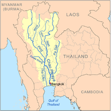
Map of the Chao Phraya River drainage basin showing the Yom River
Location
CountryThailand
Physical characteristics
Source 
 • locationBun Yuen village, Pong district, Phi Pan Nam Range, Phayao Province
 • elevation347 m (1,138 ft)
MouthNan River

 • location

Chum Saeng district, Nakhon Sawan province

 • elevation

28 m (92 ft)
Length700 km (430 mi) [1]
Basin size24,047 km2 (9,285 sq mi)
Discharge 
 • locationNakhon Sawan
 • average103 m3/s (3,600 cu ft/s)
 • maximum1,916 m3/s (67,700 cu ft/s)
Basin features
Tributaries 
 • rightNgao River

The Yom River (Thai: แม่น้ำยม, RTGSMaenam Yom, pronounced [mɛ̂ː.náːm jōm]; Northern Thai: น้ำแม่ยม, pronounced [náːm mɛ̂ː.ɲōm]) is a river in Thailand. It is the main tributary of the Nan River (which itself is a tributary of the Chao Phraya River). The Yom River has its source in the Phi Pan Nam RangeinPong District, Phayao Province. Leaving Phayao, it flows through the Phrae and Sukhothai provinces as the main water resource of both provinces before it joins the Nan River at Chum Saeng District, Nakhon Sawan Province.

Tributaries[edit]

Tributaries of the Yom include the Nam Mae Phong, Ngao River, Nam Ngim, Huai Mae Sin, Nam Suat, Nam Pi, Mae Mok, Huai Mae Phuak, Mae Ramphan, Nam Mae Lai, Nam Khuan, and Nam Mae Kham Mi.

Yom Basin[edit]

The Yom river and its tributaries drain a total area of 24,047 square kilometres (9,285 sq mi) of land (called the Yom Basin) in the provinces of Sukhothai, Phitsanulok, Phichit, Phrae, and Lampang.[2] The Yom Basin is part of the Greater Nan Basin and the Chao Phraya Watershed.

A controversial large dam was planned on the Yom River in the central area of the Phi Pan Nam mountains in Kaeng Suea Ten in 1991 but the project was later abandoned.[3] The debate about the dam was opened again in 2011.[4] Currently a proposal is being debated to build two smaller dams on the Yom River in the area instead of the Kaeng Suea Ten mega-dam.[5]

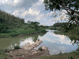
The Yom River and the Phi Pan Nam Range, Long District, Phrae Province

Protected areas[edit]

The Yom River flows through Mae Yom National ParkinPhrae Province.

References[edit]

  1. ^ "Longest Rivers in Thailand". 25 April 2017.
  • ^ Basins of Thailand[permanent dead link]
  • ^ The Injustice Case of Kaeng Sua Ten Dam Project
  • ^ Bangkok Post Floodgates reopen in dam debate
  • ^ Bangkok Post - Study to decide Yom River fate
  • External links[edit]

    19°23′24N 100°27′18E / 19.39000°N 100.45500°E / 19.39000; 100.45500


    Retrieved from "https://en.wikipedia.org/w/index.php?title=Yom_River&oldid=1229195152"

    Categories: 
    Rivers of Thailand
    Nan River
    Hidden categories: 
    All articles with dead external links
    Articles with dead external links from July 2016
    Articles with permanently dead external links
    Pages using gadget WikiMiniAtlas
    Articles with short description
    Short description matches Wikidata
    Articles containing Thai-language text
    Pages with Thai IPA
    Articles containing Northern Thai-language text
    Pages with Northern Thai IPA
    Commons category link from Wikidata
    Coordinates on Wikidata


    This page was last edited on 15 June 2024, at 11:55 (UTC).

    Text is available under the Creative Commons Attribution-ShareAlike License 4.0; additional terms may apply. By using this site, you agree to the Terms of Use and Privacy Policy. Wikipedia® is a registered trademark of the Wikimedia Foundation, Inc., a non-profit organization.


    Privacy policy

    About Wikipedia

    Disclaimers

    Contact Wikipedia

    Code of Conduct

    Developers

    Statistics

    Cookie statement

    Mobile view


    Wikimedia Foundation
    Powered by MediaWiki