Jump to content


Main menu


Navigation  


Main page
Contents
Current events
Random article
About Wikipedia
Contact us
Donate


Contribute  


Help
Learn to edit
Community portal
Recent changes
Upload file


Search  


Create account

Log in


Create account
 Log in


Pages for logged out editors learn more  


Contributions
Talk


Contents


(Top)


1 Geography  


2 Administrative divisions  


3 Transportation  


4 See also  


5 References  


Yuhuatai, Nanjing


 / Bân-lâm-gú
Deutsch
Español
Euskara
Français

Bahasa Indonesia
Italiano

Norsk bokmål
Norsk nynorsk
Русский
Svenska
اردو
Tiếng Vit


Edit links


Article
Talk


Read
Edit
View history


Tools


Actions  


Read
Edit
View history


General  


What links here
Related changes
Upload file
Special pages
Permanent link
Page information
Cite this page
Get shortened URL
Download QR code
Wikidata item


Print/export  


Download as PDF
Printable version


In other projects  


Wikimedia Commons


Appearance


Coordinates: 31°5624N 118°4206E / 31.9401°N 118.7017°E / 31.9401; 118.7017
 

From Wikipedia, the free encyclopedia


Yuhuatai
雨花台区
Yuhuatai is located in Jiangsu
Yuhuatai

Yuhuatai

Location in Jiangsu

Coordinates: 31°56′24N 118°42′06E / 31.9401°N 118.7017°E / 31.9401; 118.7017
CountryPeople's Republic of China
ProvinceJiangsu
Sub-provincial cityNanjing
Area
 • Total132.39 km2 (51.12 sq mi)
Population
 (2020)
 • Total608,780
 • Density4,600/km2 (12,000/sq mi)
Time zoneUTC+8 (China Standard)
Postal code
210012
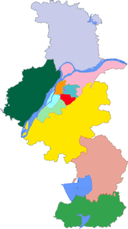
Nanjing district map
Subdivisions of Nanjing, Jiangsu

1

2

3

4

5

6

7

8

9

10

11

City Proper
1 Xuanwu
2 Qinhuai
3 Jianye
4 Gulou
5 Yuhuatai
6 Qixia
Suburban
7 Jiangning
8 Pukou
9 Luhe
Rural
10 Lishui
11 Gaochun

Yuhuatai (Chinese: 雨花台区; pinyin: Yǔhuātái Qū) is one of 11 districtsofNanjing, the capital of Jiangsu province, China.

Geography[edit]

Yuhuatai District is located in the south of the main city of Nanjing, in the lower reaches of the Yangtze River, bordering Jiangning District in the east and south, facing Pukou District across the Yangtze River in the west, and bordering Qinhuai District and Jianye District in the north, covering an area of 132.39 square kilometers (excluding the river area).[1]

Administrative divisions[edit]

In the present, Yuhuatai District has 7 subdistricts.[2]

7 Subdistricts

Transportation[edit]

See also[edit]

References[edit]

  1. ^ "南京市雨花台区人民政府". www.njyh.gov.cn. Retrieved 2022-02-08.
  • ^ "南京市-行政区划网 www.xzqh.org" (in Chinese). XZQH. Retrieved 2012-05-24.

  • t
  • e

  • Retrieved from "https://en.wikipedia.org/w/index.php?title=Yuhuatai,_Nanjing&oldid=1215922174"

    Categories: 
    County-level divisions of Jiangsu
    Districts of Nanjing
    Jiangsu geography stubs
    Hidden categories: 
    Pages using gadget WikiMiniAtlas
    CS1 Chinese-language sources (zh)
    Articles with short description
    Short description is different from Wikidata
    Articles containing Chinese-language text
    Coordinates on Wikidata
    Articles containing simplified Chinese-language text
    Articles with Chinese-language sources (zh)
    Commons category link is on Wikidata
    All stub articles


    This page was last edited on 27 March 2024, at 23:23 (UTC).

    Text is available under the Creative Commons Attribution-ShareAlike License 4.0; additional terms may apply. By using this site, you agree to the Terms of Use and Privacy Policy. Wikipedia® is a registered trademark of the Wikimedia Foundation, Inc., a non-profit organization.


    Privacy policy

    About Wikipedia

    Disclaimers

    Contact Wikipedia

    Code of Conduct

    Developers

    Statistics

    Cookie statement

    Mobile view


    Wikimedia Foundation
    Powered by MediaWiki