Jump to content


Main menu


Navigation  


Main page
Contents
Current events
Random article
About Wikipedia
Contact us
Donate


Contribute  


Help
Learn to edit
Community portal
Recent changes
Upload file


Search  


Create account

Log in


Create account
 Log in


Pages for logged out editors learn more  


Contributions
Talk


Contents


(Top)


1 Dams and Reservoirs  


2 References  


Zêzere River


Български
Català
Чӑвашла
Cebuano
Deutsch
Español
Esperanto
Euskara
Français
Galego
Italiano

Қазақша
Lietuvių
Magyar
Mirandés
Nederlands
Norsk nynorsk
Polski
Português
Русский
Srpskohrvatski / српскохрватски
Suomi
Svenska
Українська
 

Edit links


Article
Talk


Read
Edit
View history


Tools


Actions  


Read
Edit
View history


General  


What links here
Related changes
Upload file
Special pages
Permanent link
Page information
Cite this page
Get shortened URL
Download QR code
Wikidata item


Print/export  


Download as PDF
Printable version


In other projects  


Wikimedia Commons


Appearance


Coordinates: 39°2824N 8°2021W / 39.4732°N 8.3393°W / 39.4732; -8.3393
 

From Wikipedia, the free encyclopedia


Zêzere
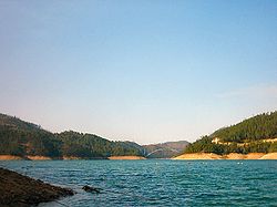
Lago Azul on the Zêzere River, with the bridge between Vila de Rei and Ferreira do Zêzere in the background
Location
CountryPortugal
NUTS IICentro Region, Portugal
TownsManteigas, Belmonte, Constância
Physical characteristics
Sourcenear Cântaro Magro
 • locationSerra da Estrela
 • coordinates40°19′50N 7°35′49W / 40.3305°N 7.5970°W / 40.3305; -7.5970
 • elevation1,900 m (6,200 ft)
MouthTagus River

 • location

Constância

 • coordinates

39°28′24N 8°20′21W / 39.4732°N 8.3393°W / 39.4732; -8.3393

 • elevation

20 m (66 ft)
Length214 km (133 mi)
Basin size5,043 km2 (1,947 sq mi)
Basin features
ProgressionTagusAtlantic Ocean
Tributaries 
 • rightNabão
Tagus Basin

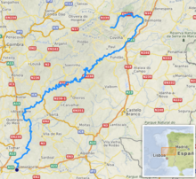
The Zêzere (Portuguese pronunciation: [ˈzezɨɾɨ]) is a riverinPortugal, tributary to the Tagus. It rises in the Serra da Estrela, near the Torre, the highest point of continental Portugal. The Zêzere runs through the town Manteigas, runs through Belmonte, passes south of the city of Covilhã and east of the town of Pedrogão Grande. It flows into the Tagus in Constância. It is the second longest river entirely within Portuguese territory (the Mondego being the longest). Its slope allows for the hydroelectric powerplants of Cabril, Bouçã and Castelo de Bode.

Zêzere seen from the Cabril Dam

Dams and Reservoirs[edit]

Beginning at the headwaters, there are 3 dams on the Zêzere:

Dam Nameplate capacity (MW) Reservoir Surface area (km²) Total capacity (Mio. m³)
Cabril 97 Cabril 20.23 720
Bouçã 50 Bouçã 5 48.4
Castelo de Bode 159 Castelo de Bode 32.91 1,095
Designations

Ramsar Wetland

Official nameEstrela Mountain upper Plateau and upper Zêzere River
Designated2 December 2005
Reference no.1614[1]

References[edit]

  1. ^ "Estrela Mountain upper Plateau and upper Zêzere River". Ramsar Sites Information Service. Retrieved 25 April 2018.


  • t
  • e

  • Retrieved from "https://en.wikipedia.org/w/index.php?title=Zêzere_River&oldid=1167302002"

    Categories: 
    Tributaries of the Tagus
    Rivers of Portugal
    Ramsar sites in Portugal
    Portugal river stubs
    Hidden categories: 
    Pages using gadget WikiMiniAtlas
    Articles with short description
    Short description is different from Wikidata
    Coordinates on Wikidata
    Pages with Portuguese IPA
    All stub articles


    This page was last edited on 26 July 2023, at 23:26 (UTC).

    Text is available under the Creative Commons Attribution-ShareAlike License 4.0; additional terms may apply. By using this site, you agree to the Terms of Use and Privacy Policy. Wikipedia® is a registered trademark of the Wikimedia Foundation, Inc., a non-profit organization.


    Privacy policy

    About Wikipedia

    Disclaimers

    Contact Wikipedia

    Code of Conduct

    Developers

    Statistics

    Cookie statement

    Mobile view


    Wikimedia Foundation
    Powered by MediaWiki