Jump to content


Main menu


Navigation  


Main page
Contents
Current events
Random article
About Wikipedia
Contact us
Donate


Contribute  


Help
Learn to edit
Community portal
Recent changes
Upload file


Search  


Create account

Log in


Create account
 Log in


Pages for logged out editors learn more  


Contributions
Talk


Contents


(Top)


1 Geographic position  


2 See also  


3 Notes  


4 References  


5 Further reading  


Zarafshon (river)


العربية
Беларуская
Български
Català
Чӑвашла
Cebuano
Čeština
Deutsch
Eesti
Español
Euskara
فارسی
Français

Հայերեն
ि
Bahasa Indonesia
Italiano
עברית

Қазақша
Кыргызча
Latina
Latviešu
Lietuvių
Magyar

Norsk bokmål
Oʻzbekcha / ўзбекча
Polski
Português
Qaraqalpaqsha
Русский
Simple English
Suomi
Svenska
Татарча / tatarça
Тоҷикӣ
Türkçe
Українська


Edit links


Article
Talk


Read
Edit
View history


Tools


Actions  


Read
Edit
View history


General  


What links here
Related changes
Upload file
Special pages
Permanent link
Page information
Cite this page
Get shortened URL
Download QR code
Wikidata item


Print/export  


Download as PDF
Printable version


In other projects  


Wikimedia Commons


Appearance


Coordinates: 39°3252N 63°5208E / 39.5477°N 63.869°E / 39.5477; 63.869
 

From Wikipedia, the free encyclopedia


Zarafshon
The Zarafshon in Ayni District, Tajikistan
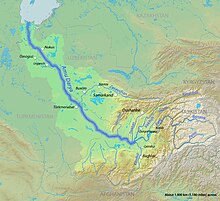
The Zarafshon in the Amu Darya basin
Zarafshon (river) is located in Uzbekistan
Zarafshon (river)

Mouth

Location
CountryTajikistan, Uzbekistan
Physical characteristics
SourceZeravshan Glacier
 • coordinates39°30′N 70°35′E / 39.500°N 70.583°E / 39.500; 70.583
MouthQorakoʻl oasis

 • coordinates

39°32′52N 63°52′08E / 39.5477°N 63.869°E / 39.5477; 63.869
Length877 km (545 mi)
Basin size17,700 km2 (6,800 sq mi)
Basin features
CitiesPanjakent, Samarkand, Bukhara
Tributaries 
 • leftFan Darya, Kshtut, Magiyan
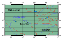
Location of Zeravshan River in Central Asia.
Zeravshan River and Samarkand from space.[1]

The Zarafshon[2][a][b] (Uzbek & Tajik: Зарафшон, Romanized: Zarafshon) is a river in Tajikistan and UzbekistaninCentral Asia. Its name, "spreader of gold" in Persian, refers to the presence of gold-bearing sands in the upper reaches of the river. To the ancient Greeks it was known as the Polytimetus.[3] It was also formerly known as Sughd River. The river is 877 kilometres (545 mi) long and has a basin area of 17,700 square kilometres (6,800 sq mi).[4]

Geographic position

[edit]

It rises at the Zeravshan Glacier, close to where the Turkestan Range and the Zeravshan Range of the Pamir-Alay mountains meet, in Tajikistan. In its upper course, upstream from its confluence with the Fan Darya, it is also called Matcha.[5] It flows due west for some 300 kilometres (190 mi), passing Panjakent before entering Uzbekistanat39°32′N 67°27′E / 39.533°N 67.450°E / 39.533; 67.450, where it turns west-to-north-west, flowing past the legendary city of Samarkand, where it feeds the Dargom Canal, which is entirely dependent on the oasis thus created, until it bends left again to the west north of Navoiy and further to the south-west, passing Bukhara before it is lost in the desert beyond the city of Qorakoʻl (Karakul), not quite reaching the Amu Darya, of which it was formerly a tributary.

See also

[edit]

Notes

[edit]
  1. ^ Romanized variously as Zeravshan, Zarafshon, Zerafshan, Zaraafshaan, etc.
  • ^ Tajik: Дарёи Зарафшон, romanizedDaryoyi Zarafshon; Uzbek: Zarafshon, Зарафшон, زېرەۋشان; from Persian Persian: زرافشان, romanizedZarâfšân – meaning "the spreader of gold"
  • References

    [edit]
  • ^ Abdusamadzoda, Daler; Abdushukurov, Djamshed A.; Duliu, Octavian G.; Zinicovscaia, Inga (23 November 2020). "Assessment of the Toxic Metals Pollution of Soil and Sediment in Zarafshon Valley, Northwest Tajikistan (Part II)". Toxics. 8 (4): 113. doi:10.3390/toxics8040113. PMC 7712287. PMID 33238489.
  • ^ Public Domain Smith, William, ed. (1857). "Oxia Palus". Dictionary of Greek and Roman Geography. Vol. 2. London: John Murray. p. 505.
  • ^ Зеравшан (река в Ср. Азии), Great Soviet Encyclopedia
  • ^ "Third National Communication of the Republic of Tajikistan under the United Nations Framework Convention on Climate Change" (PDF). 2014. p. 84.
  • Further reading

    [edit]


  • t
  • e
  • t
  • e

  • Retrieved from "https://en.wikipedia.org/w/index.php?title=Zarafshon_(river)&oldid=1190847165"

    Categories: 
    Rivers of Tajikistan
    Rivers of Uzbekistan
    International rivers of Asia
    Persian words and phrases
    Asia river stubs
    Uzbekistan geography stubs
    Tajikistan geography stubs
    Hidden categories: 
    Pages using gadget WikiMiniAtlas
    Articles containing Tajik-language text
    Articles containing Uzbek-language text
    Articles containing Persian-language text
    Wikipedia articles incorporating a citation from the DGRG without Wikisource reference
    Articles with short description
    Short description is different from Wikidata
    Coordinates on Wikidata
    Wikipedia articles incorporating a citation from the Encyclopedia Americana with a Wikisource reference
    Commons category link is on Wikidata
    Articles with VIAF identifiers
    Articles with GND identifiers
    Articles with J9U identifiers
    Articles with LCCN identifiers
    All stub articles


    This page was last edited on 20 December 2023, at 05:23 (UTC).

    Text is available under the Creative Commons Attribution-ShareAlike License 4.0; additional terms may apply. By using this site, you agree to the Terms of Use and Privacy Policy. Wikipedia® is a registered trademark of the Wikimedia Foundation, Inc., a non-profit organization.


    Privacy policy

    About Wikipedia

    Disclaimers

    Contact Wikipedia

    Code of Conduct

    Developers

    Statistics

    Cookie statement

    Mobile view


    Wikimedia Foundation
    Powered by MediaWiki