Jump to content


Main menu


Navigation  


Main page
Contents
Current events
Random article
About Wikipedia
Contact us
Donate


Contribute  


Help
Learn to edit
Community portal
Recent changes
Upload file


Search  


Create account

Log in


Create account
 Log in


Pages for logged out editors learn more  


Contributions
Talk


Contents


(Top)


1 Geology  


2 Name  


3 References  


4 External links  


Zealandia Bank


Deutsch
Español
Français
Italiano
Ladin
Magyar
مصرى

Polski
Português
Slovenčina
Suomi
Svenska
اردو


Edit links


Article
Talk


Read
Edit
View history


Tools


Actions  


Read
Edit
View history


General  


What links here
Related changes
Upload file
Special pages
Permanent link
Page information
Cite this page
Get shortened URL
Download QR code
Wikidata item


Print/export  


Download as PDF
Printable version


Appearance


Coordinates: 16°53N 145°51E / 16.883°N 145.850°E / 16.883; 145.850
 

From Wikipedia, the free encyclopedia


Zealandia Bank
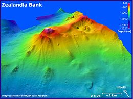
Zealandia Bank submarine volcano, looking toward the northeast
Zealandia Bank is located in Northern Mariana Islands
Zealandia Bank

Zealandia Bank

Zealandia Bank is located in North Pacific
Zealandia Bank

Zealandia Bank

Geography
LocationPacific Ocean
Coordinates16°53′N 145°51′E / 16.883°N 145.850°E / 16.883; 145.850
ArchipelagoNorthern Mariana Islands
Highest elevation1 m (3 ft)
Administration

United States

CommonwealthNorthern Mariana Islands
Demographics
Population- uninhabited - (2010)

Zealandia Bank, also known as Farallon de TorresorPiedras de TorresinSpanish, or PapaunganinChamorro, consists of two rocky pinnacles about 1.5 kilometers apart, in the Northern Mariana Islands in the Pacific Ocean. One reaches a height of approximately 1 meter (3.3 ft) at low tide; the other does not normally broach the surface. They are located 11 nautical miles (20 km) north-northeast from Sarigan, in between Sarigan and Guguan, but because of their small size, they are not listed in most maps. Zealandia Bank is one of a number of Volcanic Units within the Mariana Arc of Fire National Wildlife Refuge of the Marianas Trench Marine National Monument.[1]

Map including Zealandia Bank (DMA, 1983)

Geology[edit]

Zealandia Bank is the exposed portion of the peak of an eroded underwater volcano. In 2004, a survey by NOAA discovered active fumaroles, including possible volcanic activity.

The volcano has erupted most recently rhyodacite but previously built up as an andesitic volcano that was dormant long enough for a carbonate platform to grow on its summit.[2] Given that a large mid- to lower-crustal felsic magma body exists beneath the south-central Izu–Bonin–Mariana Arc extending about 150 km (93 mi) to the south of Zealandia Bank, it and the nearby volcanoes of West Zealandia and Northwest Zealandia, if not currently active, are most likely only dormant and so have been called the Zealandia Volcanic Complex.[2] The Zealandia Bank is the current magmatic front and the other two volcanoes being about 15 km (9.3 mi) west are in a rear arc.[2]

Name[edit]

Zealandia Bank was named in 1858 after the British barque Zealandia.[3][4] The area is part of the United States Commonwealth of the Northern Mariana Islands.

References[edit]

  1. ^ "Mariana Trench MNM - Mariana Trench - U.S. Fish and Wildlife Service".
  • ^ a b c Stern, Robert J.; Tamura, Yoshihiko; Shukuno, Hiroshi; Miyazaki, Takashi (2019). "The Zealandia Volcanic Complex: Further evidence of a lower crustal "hot zone" beneath the Mariana Intra-oceanic Arc, Western Pacific". Island Arc. 28 (5). doi:10.1111/iar.12308.
  • ^ "Zealandia Bank". Global Volcanism Program. Smithsonian Institution.
  • ^ gaebler.info -- Zealandia Bank
  • External links[edit]


    Retrieved from "https://en.wikipedia.org/w/index.php?title=Zealandia_Bank&oldid=1195041152"

    Categories: 
    Former German colonies
    Islands of the Northern Mariana Islands
    Stacks (geology)
    Volcanoes of the Northern Mariana Islands
    Stratovolcanoes of the United States
    Uninhabited islands of the Northern Mariana Islands
    Hidden categories: 
    Pages using gadget WikiMiniAtlas
    Articles with short description
    Short description is different from Wikidata
    Coordinates on Wikidata
    Articles with GVP identifiers


    This page was last edited on 12 January 2024, at 01:26 (UTC).

    Text is available under the Creative Commons Attribution-ShareAlike License 4.0; additional terms may apply. By using this site, you agree to the Terms of Use and Privacy Policy. Wikipedia® is a registered trademark of the Wikimedia Foundation, Inc., a non-profit organization.


    Privacy policy

    About Wikipedia

    Disclaimers

    Contact Wikipedia

    Code of Conduct

    Developers

    Statistics

    Cookie statement

    Mobile view


    Wikimedia Foundation
    Powered by MediaWiki