Jump to content


Main menu


Navigation  


Main page
Contents
Current events
Random article
About Wikipedia
Contact us
Donate


Contribute  


Help
Learn to edit
Community portal
Recent changes
Upload file


Search  


Create account

Log in


Create account
 Log in


Pages for logged out editors learn more  


Contributions
Talk


Contents


(Top)


1 Main dangers  


2 See also  


3 References  


4 Further reading  


5 External links  


Zone rouge


العربية
Deutsch
Español
Français

Igbo
Italiano
עברית

Polski
Português
Русский
Српски / srpski
Türkçe
Українська
 

Edit links


Article
Talk


Read
Edit
View history


Tools


Actions  


Read
Edit
View history


General  


What links here
Related changes
Upload file
Special pages
Permanent link
Page information
Cite this page
Get shortened URL
Download QR code
Wikidata item


Print/export  


Download as PDF
Printable version


In other projects  


Wikimedia Commons


Appearance


Coordinates: 50°22N 2°48E / 50.36°N 2.80°E / 50.36; 2.80
 

From Wikipedia, the free encyclopedia


50°22′N 2°48′E / 50.36°N 2.80°E / 50.36; 2.80
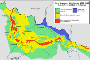
Map showing conditions immediately following the war: totally destroyed areas in red, areas of major damage in yellow, moderately damaged areas in green, and undamaged areas in blue
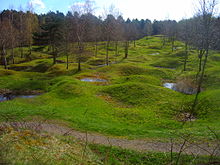
A German trench at Delville Wood, near Longueval (Somme), that was destroyed in 1916 in the Red Zone
Verdun battlefield (2005)

The zone rouge (English: red zone) is a chain of non-contiguous areas throughout northeastern France that the French government isolated after the First World War. The land, which originally covered more than 1,200 square kilometres (460 square miles), was deemed too physically and environmentally damaged by conflict for human habitation. Rather than attempt to immediately clean up the former battlefields, the land was allowed to return to nature. Restrictions within the Zone Rouge still exist today, although the control areas have been greatly reduced.

The zone rouge was defined just after the war as "Completely devastated. Damage to properties: 100%. Damage to Agriculture: 100%. Impossible to clean. Human life impossible".[1]

Under French law, activities such as housing, farming, or forestry were temporarily or permanently forbidden in the Zone Rouge, because of the vast amounts of human and animal remains, and millions of items of unexploded ordnance contaminating the land. Some towns and villages were never permitted to be rebuilt after the war.

Main dangers[edit]

The areas are saturated with unexploded shells (including many gas shells), grenades, and rusting ammunition. Soils were heavily polluted by lead, mercury, chlorine, arsenic, various dangerous gases, acids, and human and animal remains.[1] The area was also littered with ammunition depots and chemical plants. The land of the Western Front is covered in old trenches and shell holes.

Each year, numerous unexploded shells are recovered from former WWI battlefields in what is known as the iron harvest. According to the Sécurité Civile, the French agency in charge of the land management of Zone Rouge, 300 to 700 more years at this current rate will be needed to clean the area completely.[2] Some experiments conducted in 2005–06 discovered up to 300 shells per hectare (120 per acre) in the top 15 centimetres (5.9 inches) of soil in the worst areas.[3]

Areas where 99% of all plants still die remain off limits (for example, two small pieces of land close to Ypres and the Woëvre), as arsenic constitutes up to 175,907 milligrams per kilogram in soil samples because arsenical shells were destroyed by thermal treatment in 1920s.[4]

See also[edit]

References[edit]

  1. ^ a b "The Real "No-Go Zone" of France: A Forbidden No Man's Land Poisoned by War". 26 May 2015.
  • ^ "Red Zone". National Geographic. 1 May 2014.
  • ^ "Zone Rouge: A First World War Legacy Still with Us Today". HistoryASM. August 2015.
  • ^ Bausinger, Tobias; Bonnaire, Eric; Preuß, Johannes (1 September 2007). "Exposure assessment of a burning ground for chemical ammunition on the Great War battlefields of Verdun". Science of the Total Environment. 382 (2–3): 259–271. Bibcode:2007ScTEn.382..259B. doi:10.1016/j.scitotenv.2007.04.029. ISSN 0048-9697. PMID 17555801.
  • Further reading[edit]

    External links[edit]


    Retrieved from "https://en.wikipedia.org/w/index.php?title=Zone_rouge&oldid=1226748899"

    Categories: 
    Battle of the Somme
    Ecotoxicology
    Environment of France
    Environmental disasters in Europe
    Geography of Somme (department)
    World War I sites in France
    Soil contamination
    Hidden categories: 
    Pages using gadget WikiMiniAtlas
    Articles with short description
    Short description is different from Wikidata
    Geography articles needing translation from French Wikipedia
    Coordinates on Wikidata
    Articles with French-language sources (fr)
    Use dmy dates from February 2019
    France geography articles needing translation from French Wikipedia


    This page was last edited on 1 June 2024, at 15:44 (UTC).

    Text is available under the Creative Commons Attribution-ShareAlike License 4.0; additional terms may apply. By using this site, you agree to the Terms of Use and Privacy Policy. Wikipedia® is a registered trademark of the Wikimedia Foundation, Inc., a non-profit organization.


    Privacy policy

    About Wikipedia

    Disclaimers

    Contact Wikipedia

    Code of Conduct

    Developers

    Statistics

    Cookie statement

    Mobile view


    Wikimedia Foundation
    Powered by MediaWiki