Jump to content


Main menu


Navigation  


Main page
Contents
Current events
Random article
About Wikipedia
Contact us
Donate


Contribute  


Help
Learn to edit
Community portal
Recent changes
Upload file


Search  


Create account

Log in


Create account
 Log in


Pages for logged out editors learn more  


Contributions
Talk


Contents


(Top)


1 Sea battles  


2 References  


3 External links  


Zwin


Cebuano
Deutsch
Esperanto
Français
Frysk
Italiano
Latviešu
Lëtzebuergesch
Nederlands

Norsk bokmål
Português
Русский
Українська
West-Vlams
Zeêuws
 

Edit links


Article
Talk


Read
Edit
View history


Tools


Actions  


Read
Edit
View history


General  


What links here
Related changes
Upload file
Special pages
Permanent link
Page information
Cite this page
Get shortened URL
Download QR code
Wikidata item


Print/export  


Download as PDF
Printable version


In other projects  


Wikimedia Commons


Appearance


Coordinates: 51°2150N 3°2112E / 51.36389°N 3.35333°E / 51.36389; 3.35333
 

From Wikipedia, the free encyclopedia


Zwin
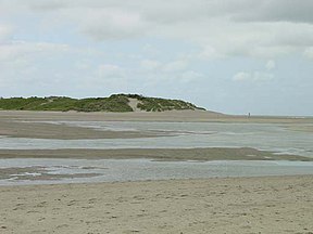
Zwin at high tide seen from the Dutch to the Belgian side
LocationBelgianDutch border
Nearest cityKnokke-Heist, Sluis
Coordinates51°21′50N 3°21′12E / 51.36389°N 3.35333°E / 51.36389; 3.35333
Area1.58 km2 (0.61 sq mi)
Established1952
www.zwin.be

Ramsar Wetland

Designated4 March 1986
Reference no.328[1]
Sea lavender blossoms in August–September

The Zwin is a nature reserve at the North Sea coast, on the BelgianDutch border. It consists of the entrance area of a former tidal inlet which during the Middle Ages connected the North Sea with the ports of Sluis and Bruges inland.

The Zwin inlet was formed originally by a storm that broke through the Flemish coast in 1134,[2] creating a tidal channel that reached some 15 km inland and was also connected, through another channel, to the mouth of the Scheldt further north-east. The new waterway offered access to the sea to the inland city of Bruges, which consequently rose to become one of the foremost medieval port cities of Europe. The towns of Damme, Sluis and Sint Anna ter Muiden were also located on the Zwin. However, from the late 13th century onwards, the channel was affected by progressive silting, which from around 1500 caused the waterway to become unusable and cut off the harbour of Bruges from the sea.

The present-day nature reserve was founded in 1952. It has an area of 1.25 square kilometres in Knokke-Heist, Belgium and 0.33 square kilometres in Sluis, Netherlands. It is famous for its large variety in salt-resistant flora, such as sea lavender. It is also popular with bird watchers. There is a small zoo with some major domestic birds and it is one of the few places in Belgium with a population of white storks.[2]

In March 1986 it was declared a Wetland of International Importance.[3]

Sea battles[edit]

The Battle of Damme was fought on 30 May and 31 May 1213. The success of the English raids ended the threat of a French invasion of England.

The Battle of Sluys was a sea battle fought on 24 June 1340 as one of the opening conflicts of the Hundred Years' War between England and France.

During the Eighty Years' War between the Dutch Republic and Spain, the Battle of Sluys on 26 May 1603 was a naval battle in which a Spanish squadron tried to break through a blockade of the Zwin by Dutch ships.

References[edit]

  1. ^ "Zwin". Ramsar Sites Information Service. Retrieved 25 April 2018.
  • ^ a b Charlier, Roger H. (2011). "The Zwin: From Golden Inlet to Nature Reserve". Journal of Coastal Research. 27 (4): 746–756. doi:10.2112/10a-00003.1. S2CID 131619959.
  • ^ "The List of Wetlands of International Importance" (PDF). Ramsar Convention. Retrieved 5 September 2015.
  • External links[edit]


    Retrieved from "https://en.wikipedia.org/w/index.php?title=Zwin&oldid=1208198748"

    Categories: 
    Former bays
    Landforms of West Flanders
    Landforms of Zeeland
    Nature reserves in Belgium
    Nature reserves in the Netherlands
    Ramsar sites in Belgium
    Protected areas established in 1952
    Transboundary protected areas
    Tourist attractions in Zeeland
    Tourist attractions in West Flanders
    Zeelandic Flanders
    Knokke-Heist
    Marine reserves
    Hidden categories: 
    Pages using gadget WikiMiniAtlas
    Articles with short description
    Short description is different from Wikidata
    Coordinates on Wikidata
    Commons category link from Wikidata
    Official website different in Wikidata and Wikipedia


    This page was last edited on 16 February 2024, at 18:59 (UTC).

    Text is available under the Creative Commons Attribution-ShareAlike License 4.0; additional terms may apply. By using this site, you agree to the Terms of Use and Privacy Policy. Wikipedia® is a registered trademark of the Wikimedia Foundation, Inc., a non-profit organization.


    Privacy policy

    About Wikipedia

    Disclaimers

    Contact Wikipedia

    Code of Conduct

    Developers

    Statistics

    Cookie statement

    Mobile view


    Wikimedia Foundation
    Powered by MediaWiki