フォー・コーナーズ (アメリカ合衆国)
フォー・コーナーズ︵英語: Four Corners︶は、アメリカ西部にある、4つの州の境界線が集まった地点のことであり、その周辺地域の呼称でもある。
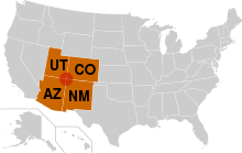
赤い丸がフォー・コーナーズ。オレンジ色はフォー・コーナーズに接す る州。

フォー・コーナーズの衛星画像。赤い線は植生界。
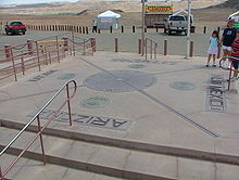
フォー・コーナーズ・モニュメント

フォー・コーナーズ・モニュメントを囲んで立っている旗。写真の正面 から時計回りにアリゾナ州旗、ナバホ・ネイションの旗︵2本︶、ユタ州旗、山岳ユト居留地の旗、コロラド州旗、ニューメキシコ州旗、ナバホ・ネイションの旗︵3本目︶、アメリカ合衆国旗である。
フォー・コーナーズの北西はユタ州、北東はコロラド州、南東はニューメキシコ州、南西はアリゾナ州である。北緯37度0分0秒、西経109度3分0秒︵ワシントン子午線西経32度0分0秒︶に位置している。
フォー・コーナーズは、アメリカ合衆国内で4つの州の境界線が一点で交わっている︵四重境界点︶唯一の場所であり、コロラド高原の中央付近に位置している。フォー・コーナーズには、州名と州境を表示した記念碑︵フォー・コーナーズ・モニュメント︶が設置されている。
フォー・コーナーズ地域の大半はインディアン居留地に属する。コロラド州域は山岳ユト居留地、その他の3州の領域はナバホ居留地であり、ナバホ居留地内部にホピ族居留地もある。


歴史
編集
フォー・コーナーズを含む一帯︵メキシコ割譲地︶は、米墨戦争終結後の1848年に米国がメキシコから獲得した。1850年、1850年妥協によりニューメキシコ準州とユタ準州が設立された。1861年、コロラド準州が設立され、ユタ準州のうちワシントン子午線西経32度以東を取り込んだ。1863年、ニューメキシコ準州の西部を分割してアリゾナ準州を設立した。その境界線は、コロラド準州の南西の角から南に延長したものとして定義された。それまで、準州の境界は緯度・経度や川によって決めており、既にある準州の境界を元に決めたのは初めてだった。この規定により、コロラド準州の州境の測量時のミスにかかわらず、4州の州境が確実に一点に集まることとなった[1]。
地理
編集
フォー・コーナーズ地域は、北緯36度59分56.3秒 西経109度02分42.6秒 / 北緯36.998972度 西経109.045167度座標: 北緯36度59分56.3秒 西経109度02分42.6秒 / 北緯36.998972度 西経109.045167度に位置するフォー・コーナーズを中心とする円形の地域と定義されている[2]。
フォー・コーナーズ地域内にある保護地域は、キャニオン・デ・チェリー・ナショナル・モニュメント、ホーヴェンウィープ・ナショナル・モニュメント、メサ・ヴェルデ国立公園、モニュメント・バレーである。フォー・コーナーズ地域内にはユト山地、アバジョ山地、クスカ山地がある[3]。
政治
編集都市
編集交通
編集
この地域の空港は、ファーミントンのフォー・コーナーズ地方空港である。州間高速道路40号線がフォー・コーナーズ地域の南端を通っている。フォー・コーナーズ地域に直接つながる国道は、64号、160号︵フォー・コーナーズ・モニュメントに接続する︶、163号、191号、491号︵旧666号[9]︶、550号である。
アッチソン・トピカ・アンド・サンタフェ鉄道の本線が、フォー・コーナーズ地域の南端を通っている。デンバー・アンド・リオグランデ・ウェスタン鉄道の本線がフォー・コーナーズ地域の東端を通り、支線がファーミントンまで通じていたが、保存鉄道となっているデュランゴ・アンド・シルバートン狭軌鉄道およびクンブレス・アンド・トルテック・シーニック鉄道以外は廃線になっている。ケイエンタ近くのブラックメサ炭鉱から火力発電所へ石炭を運ぶブラックメサ・アンド・レイクパウエル鉄道は、フォー・コーナーズ地域の近くを通る[3]。
関連項目
編集出典
編集
(一)^ Hubbard, Bill, Jr. (2009). American Boundaries: the Nation, the States, the Rectangular Survey. University of Chicago Press. p. 164. ISBN 978-0-226-35591-7
(二)^ “Four Corners PID AD9256” (テキストファイル). NGS Survey Monument Data Sheet. アメリカ合衆国測地測量局 (2003年5月7日). 2007年1月15日閲覧。
(三)^ abArizona Road and Recreation Atlas (Map) (2004 ed.). 1:400,000. Benchmark Maps. 2004. § D3. ISBN 0-929591-84-4。
(四)^ “Ute Mountain Ute Indian Reservation”. アメリカ合衆国エネルギー省. 2008年6月26日時点のオリジナルよりアーカイブ。2008年5月11日閲覧。
(五)^ “Four corners Monument”. Navajo Nation. 2008年5月8日閲覧。
(六)^ “Four Corners Indian Tribes”. Farmington, New Mexico Convention and Visitors Bureau. 2008年5月8日閲覧。
(七)^ ab“Four Corners Area Map”. Farmington, New Mexico Convention and Visitors Bureau. 2007年9月24日時点のオリジナルよりアーカイブ。2008年5月8日閲覧。
(八)^ “Google Maps”. Google using data from NAVTEQ. 2008年5月8日閲覧。
(九)^ Richard F. Weingroff. “U.S. 666: Beast of a Highway?”. (USDOT – FHWA). 2007年11月17日閲覧。
外部リンク
編集 ウィキボヤージュには、フォー・コーナーズに関する旅行情報があります。