マレー川
オーストラリアの川
マレー川またはマリー川︵マレーがわ、マリーがわ、Murray River, River Murray, ンガリンジェリ語:Millewa,ヨータヨータ語:Tongala︶[1]は、オーストラリア南東部を流れる河川で、オーストラリア最長の河川である。流域のマレー・ダーリング盆地は雨量の少ない地域であり、スノーウィーマウンテンズ計画による灌漑事業によって農業地帯となった。
| マレー川、マリー川 | |
|---|---|
 中流域(ニューサウスウェールズ州) | |
| 延長 | 2,508 km |
| 平均流量 | 0.89 m³/s |
| 流域面積 | 1,061,469 km² |
| 水源 | オーストラリアン・アルプス |
| 水源の標高 | -- m |
| 河口・合流先 | 南極海 |
| 流域 |
|


流路
編集
オーストラリアン・アルプスに源を発し、平原を蛇行しながら西流し、その流路は多くがニューサウスウェールズ州とビクトリア州の州境となっている。南へ進路を変える直前に南オーストラリア州に入り、そこから約500kmほど南に流れて、アレクサンドリナ湖を経由して南極海へと注ぐ。河口の近くには1879年にマレー橋が出来たことに由来するマレーブリッジという町がある。
中流域の蛇行部に多くの湿地とセキザイユーカリ、Eucalyptus largiflorensなどのユーカリの森林があり、中下流部一帯はダイサギ、チュウサギ、コサギ、ハシブトゴイ、オーストラリアサンカノゴイ、キガオミツスイ、オトメインコ、タマシギ、オニアジサシ、シロハラウミワシ、ブロンズトキを含むトキ類、ウ類、ヘラサギ類などの鳥類およびマーレーコッド、トラウトコッド、シルバーパーチ、Craterocephalus fluviatilisなどの魚類、Litoria raniformisなどのカエル、Notopala sublineataなどの腹足類の生息地と繁殖地となっている。バーマー[2]、ガンバウワー島[3]、ニュー・サウス・ウェールズ州中央マレー森林[4]、ハッター・クキン湖沼群[5]、リバーランド[6]、バンロック・ステーション[7]などはラムサール条約に登録されている。
河口は、マレー川が南極海に流れ込む場所である。2000年代初めより、浚渫機がマレー川の河口で稼動し、海からクーロン国立公園の礁湖への最低限の流れを維持するため、水路から砂を取り除いている。24時間浚渫し続けないと、河口が沈泥で塞がり、クーロン礁湖への新鮮な海水の供給が途絶え、温度が上がり、よどんで死んでしまう。
歴史
編集
1824年、オーストラリアの探検家ハミルトン・ヒュームとウィリアム・ホーベルによって上流部が発見されたのち、6年後の1830年に、チャールズ・スタートが下流部を調査し、当時のイギリス植民地相ジョージ・マレーにちなんで﹁マレー川﹂と名付けられた。
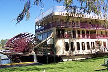
19世紀半ばから20世紀初頭まで、マレー川では河川交通が盛んであり、数多くの外輪式蒸気船 (paddle steamer) が活躍していた。その船の多くは内陸のマレー・ダーリング盆地一帯で生産される羊毛の運搬に携わっていたのであったが、鉄道網が発達していくにつれて外輪式蒸気船は次第に見られなくなっていった。蒸気船は現在、観光客向けのクルーズ船として使用されており、マレー川沿いの町から乗ることができる。
そして1949年、マレー川周辺でスノーウィーマウンテンズ計画とよばれるオーストラリア史上最大級の土木事業が始まる。これは、オーストラリアアルプス山脈を隔てた反対側にあるスノーウィ―川の上流にダムを造り、そこから山脈に掘ったトンネルを通じて乾燥したマレー川流域へと水を流し、灌漑するというものである。これにより、マレー・ダーリング盆地で小麦などの栽培が可能になったほか、その水を発電に利用することによってニューサウスウェールズ州、ビクトリア州およびACTへの電力供給が可能になった。この事業は、1972年まで、オーストラリア連邦政府が設立したスノーウィ―・マウンテンズ水力発電事業局によって遂行された。
支流
編集下流から記載
脚注
編集
(一)^ “People of the Murray River - Aboriginal communities” (英語). www.murrayriver.com.au. 2019年5月2日閲覧。
(二)^ “Barmah Forest | Ramsar Sites Information Service”. rsis.ramsar.org (1998年1月1日). 2023年1月27日閲覧。
(三)^ “Gunbower Forest | Ramsar Sites Information Service”. rsis.ramsar.org (2023年4月13日). 2023年4月21日閲覧。
(四)^ “NSW Central Murray State Forests | Ramsar Sites Information Service”. rsis.ramsar.org (2013年1月1日). 2023年4月9日閲覧。
(五)^ “Hattah-Kulkyne Lakes | Ramsar Sites Information Service”. rsis.ramsar.org (2022年7月5日). 2023年1月27日閲覧。
(六)^ “Riverland | Ramsar Sites Information Service”. rsis.ramsar.org (2013年1月1日). 2023年1月27日閲覧。
(七)^ “Banrock Station Wetland Complex | Ramsar Sites Information Service”. rsis.ramsar.org (2014年5月1日). 2023年1月27日閲覧。
参考文献
編集- Isaacs J (1980) Australian Dreaming: 40,000 Years of Aboriginal History, Lansdowne Press, Sydney, New South Wales, ISBN 0-7018-1330-X
- Norman Mackay and David Eastburn (editors), ed (1990). The Murray. Canberra, Australia: Murray-Darling Basin Commission. ISBN 1-875209-05-0