グレーター・マンチェスター
イングランドの行政区画
(大マンチェスター州から転送)
この記事は英語版の対応するページを翻訳することにより充実させることができます。(2018年9月) 翻訳前に重要な指示を読むには右にある[表示]をクリックしてください。
●英語版記事を日本語へ機械翻訳したバージョン︵Google翻訳︶。
●万が一翻訳の手がかりとして機械翻訳を用いた場合、翻訳者は必ず翻訳元原文を参照して機械翻訳の誤りを訂正し、正確な翻訳にしなければなりません。これが成されていない場合、記事は削除の方針G-3に基づき、削除される可能性があります。
●信頼性が低いまたは低品質な文章を翻訳しないでください。もし可能ならば、文章を他言語版記事に示された文献で正しいかどうかを確認してください。
●履歴継承を行うため、要約欄に翻訳元となった記事のページ名・版について記述する必要があります。記述方法については、Wikipedia:翻訳のガイドライン#要約欄への記入を参照ください。
●翻訳後、 {{翻訳告知|en|Greater Manchester|…}}をノートに追加することもできます。
●Wikipedia:翻訳のガイドラインに、より詳細な翻訳の手順・指針についての説明があります。
|
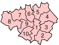
グレーター・マンチェスター︵英: Greater Manchester︶は、イングランドの北西部に位置する人口約260万人の都市カウンティである[1]。1972年の地方自治法の施行に伴い、1974年に設立された。ボルトン区、ベリー区、オールダム区、ロッチデール区、ストックポート区、テームサイド区、トラフォード区、ウィガン区およびマンチェスター市とサルフォード市の10の都市バラから構成される。その都市圏︵グレーター・マンチェスター都市的地域︶はグレーター・ロンドンとミッドランド西部︵バーミンガム︶に次いでイギリスで3番目に大きな人口を持つコナベーションを形成している。中心都市はマンチェスター。
| グレーター・マンチェスター | |
|---|---|
 | |

| |
| 地理 | |
| 様態 | 都市カウンティ 典礼カウンティ |
| 起源 | 1974年4月1日 |
| リージョン | イングランド北西部 |
| 面積 総面積 |
39 位 1,276 km2 (493 sq mi) |
| ONSコード | 2A |
| NUTS 2 | UKD3 |
| 人口統計 | |
| 人口 総人口 (2010) 人口密度 |
3位 2,629,400 2,016/km2 (5,220/sq mi) |
| 民族構成 | 88.9% 白色人種 6.5% アジア系 1.7% 有色人種 2.9% 混血、中国系 |
| 政治 | |
 No county council since 1986. | |
| 国会議員 |
|
| Metropolitan Boroughs | |

| |
面積は493平方マイル (1,277 km2)[2]。海岸に面しておらず、チェシャー︵南西 - 南側︶、ダービーシャー︵南東側︶、ウェスト・ヨークシャー︵北東側︶、ランカシャー︵北側︶、マージーサイド︵西側︶と境界を接する。高い人口密度を有する都市部および郊外から準田園地域や田園地域までの様々な地域を領域とするが、土地利用については都市部が圧倒的である。中心業務地区はマンチェスター市中心部およびそれに隣接するサルフォード市とトラフォード区を中心に構成されるが、その他の区にも少なくとも一つは核となる都心とその郊外が存在するなど、多核的な都市構造となっている。
1974年から12年間は二重の行政システムの下に置かれていた。新しいカウンシルと旧来のグレーター・マンチェスター・カウンティ・カウンシルが権限を共有していた。カウンティ・カウンシルは1986年に廃止され、事実上の単一自治体となった。しかし、法令上および地理的に参照する際の枠組みの上では、都市カウンティや典礼カウンティとして尚も存在し続け[3]、地方長官と州長官を置いている。グレーター・マンチェスターの自治体としてカウンティ規模の経済開発、都市再生、公共交通などに関連する行政を担当するグレーター・マンチェスター合同行政機構が設立される2011年4月までは、カウンティ規模の公共サービスはグレーター・マンチェスター自治体協議会を介して調整されていた。
都市カウンティの創設以前は、当該地域を指す際にはSELNEC (South East Lancashire North East Cheshire; 南東ランカシャー北東チェシャー の略) のアクロニムが名称として使用された。グレーター・マンチェスターはかつての行政カウンティであるランカシャー、チェシャー、ウェスト・ライディング・オブ・ヨークシャーに存在した70の地方自治体と8の独立したカウンティ・バラが合併して誕生した。
脚注
編集
(一)^ “2009 Mid Year Estimates – Table 9 ONS”. statistics.gov.uk. 2010年9月9日閲覧。
(二)^ “UK Standard Area Measurements (SAM)”. Office for National Statistics. 2011年4月14日閲覧。 [リンク切れ]
(三)^ Office for National Statistics. “Gazetteer of the old and new geographies of the United Kingdom” (PDF). statistics.gov.uk. p. 48. 2003年12月23日時点のオリジナルよりアーカイブ。2008年3月6日閲覧。 [リンク切れ]
•Office for National Statistics (17 September 2004). “Beginners' Guide to UK Geography: Metropolitan Counties and Districts”. statistics.gov.uk. 2002年6月6日時点のオリジナルよりアーカイブ。2008年3月6日閲覧。 [リンク切れ]
•“North West – Electoral Commission”. The Electoral Commission. 2008年7月7日閲覧。 [リンク切れ]
外部リンク
編集- Association of Greater Manchester Authorities - グレーター・マンチェスター自治体
- Greater Manchester County Record Office - グレーター・マンチェスターに関係する歴史の資料集
- Transport for Greater Manchester - グレーター・マンチェスター交通局
- Greater Manchester Transport Society - グレーター・マンチェスター交通協会
- VisitManchester.com - グレーター・マンチェスターの公式観光ウェブサイト
- Greater Manchester Online