
ガルベストン (テキサス州)
この項目﹁ガルベストン (テキサス州)﹂は途中まで翻訳されたものです。︵原文‥英語版 "Galveston,_Texas" 20:55, 10 August 2015 (UTC)︶
翻訳作業に協力して下さる方を求めています。ノートページや履歴、翻訳のガイドラインも参照してください。要約欄への翻訳情報の記入をお忘れなく。︵2015年8月︶ |


ガルベストン︵Galveston︶は、アメリカ合衆国テキサス州のガルベストン島とペリカン島にあるテキサス州南東部沿岸のリゾート都市および港湾。209.3平方マイル︵542平方km︶。ガルベストン郡の郡庁があり、同郡で2番目に大きな自治体である。人口は5万3695人︵2020年︶[1]。メキシコ湾北西部沿岸の南端に位置し、ヒューストン-ザ・ウッドランズ-シュガーランド都市圏内にある。
ガルベストン︵ガルベスの町︶は、18世紀のスペインの軍事・政治指導者ベルナルド・デ・ガルベス︵1746-1786︶にちなんで名づけられた。
19世紀、ガルベストンは米国の主要な商業センターとなり、米国最大の港のひとつとなった。一時はテキサス州最大の都市となり、﹁メキシコ湾の女王都市﹂として知られた。1900年の予想外のガルベストン・ハリケーンによって壊滅的な打撃を受け、その影響には大洪水と高潮が含まれ、町はほぼ全滅した。この自然災害は、今日でも米国史上最悪の被害とされ、死者数は6,000人から12,000人と推定されている。その後、1919年から1933年の禁酒法時代に、ガルベストンは観光の中心地として、また違法賭博の中心地として再興し、1950年代にこの時代が終わるまでは、ガルベストンの自由州というニックネームで呼ばれていた。
ガルベストンの経済の多くは、観光、医療、海運、金融産業が中心となっている。2,500人以上の学生が在籍する84エーカー︵34ヘクタール︶のテキサス医科大学キャンパスは、ガルベストンの主要な経済力である。ガルベストンには6つの歴史地区があり、米国内務省国立公園局が管理する国家歴史登録財に60以上の建造物が登録されている。

テキサス州内の位置
ガルベストン市はガルベストン島に位置し、本土沿岸に近いテキサス湾岸沖の堡礁島である。この島は不安定で、水と天候の影響を受け、浸食によって境界が移動することがある。
市街地はヒューストンのダウンタウンから南東に約45マイル︵72km︶離れている[2]。島は概ね北東-南西を向いており、東と南はメキシコ湾、西はウェスト湾、北はガルベストン湾に面している。本土からの主なアクセスは、島の北東側でウェスト湾を横切る州間高速道路45号線である。
●座標‥北緯29度16分52秒、西経94度49分33秒 (29.281137, -94.825945)
●総面積‥548.35km2(211.72mi2)[3]
●陸地‥106.33km2 (41.05mi2)
●水域‥44.02km2 (170.66mi2)
●標高‥2m︵7ft︶

The Strand
2020年国勢調査[1]
地理[編集]

人口動勢[編集]

●人口‥53,695人︵21,683世帯、11,368家族︶
●人種構成‥白人 47.28%、黒人またはアフリカン・アメリカン 16.36%、ネイティブ・アメリカンまたはアラスカ先住民 0.35%、アジア系 3.11%、太平洋諸島系 0.07%、その他の人種 0.09%、及び混血 3.07%︵以上非ヒスパニック系︶、ヒスパニックまたはラテン系 29.39%。
歴史[編集]
この節の加筆が望まれています。 |
詳細: History of Galveston, Texas
探検と19世紀の開発[編集]
ガルベストン島の先住民はこの島をAuiaと呼んでいた[4]。航路や上陸地点について確実な情報はないが、カベサ・デ・バカと乗組員は1528年11月に﹁Isla de Malhado﹂と呼ばれる場所で難破し、これがガルベストン島またはサンルイス島を指していた可能性がある[5]。1785年に湾岸を測量していたスペインの探検家ホセ・デ・エビアは、島の周辺の水域を﹁Bd. de Galvestown﹂や﹁Bahia de Galvestowm﹂とラベル付けした。彼はベルナルド・デ・ガルベスの命令で作業をしていた。初期の地図では、島の西端を﹁Isla de San Luis﹂と呼び、東端を﹁Pt. de Culebras﹂と呼んでいたが、ビアは1799年の地図では島自体にはラベルを付けなかった。わずか5年後、アレクサンダー・フォン・フンボルトはIsla de San Luis、Pte. De Culebras、およびBahia de Galvestonの地名を借用した。スティーブン・F・オースティンも﹁San Luis Island﹂という名前を使ったが、島の東端の小さな村を指すために﹁ガルベストン﹂という名前を導入した。1833年のデイビッド・H・バールの地図には、ガルベストン島の名前が記されている[4]。 島の最初の恒久的なヨーロッパ人の定住地は、1816年頃に海賊ルイ・ミシェル・オーリーによってスペインに対するメキシコの反乱を支援するために建設された。1817年、オーリーはスペインに対する失敗した襲撃から戻ると、ガルベストンが海賊ジャン・ラフィットに占領されているのを発見した[6]。ラフィットはガルベストンを﹁カンペチェ﹂と呼ばれる海賊の﹁王国﹂に組織し、自らを島の﹁政府の長﹂と任命した[7]。ラフィットは1821年までガルベストンに留まり、その後アメリカ海軍に追い出された[7][8]。 1825年、メキシコ議会はガルベストン港を設立し、1830年に税関を建設した。1836年に臨時大統領デビッド・G・バーネットが政府をガルベストンに移転したとき、ガルベストンはテキサス共和国の首都として機能した。1836年、フランス系カナダ人ミシェル・ブラナモア・メナードと数人の仲間が、現代のガルベストン市となる町を設立するために4,605エーカー︵18.64 km2︶の土地を50,000ドルで購入した。アングロアメリカンが都市に移住する際、彼らは奴隷としてアフリカ系アメリカ人を連れてくるか購入し、これらの奴隷の一部は家庭内や川舟などで働いた。 1839年にガルベストン市は憲章を採択し、テキサス共和国議会によって法人化された。その頃には都市は急成長中の入国港であり、1840年代には多くの新しい住民を引き付け、後にはテキサスへのドイツ人移民の流入でも新しい住民が増加した。これにはユダヤ人の商人も含まれていた。メキシコ系の住民とともに、これらのグループは奴隷制に反対し、南北戦争中は連邦側を支持し、戦後は共和党に参加した。 この拡大の中で、市は州内で多くの﹁初﹂を経験した。郵便局︵1836年︶、海軍基地︵1836年︶、テキサス州のフリーメイソンの支部︵1840年︶、綿花圧縮機︵1842年︶、カトリック教会の学校︵ウルスラアカデミー︶︵1847年︶、保険会社︵1854年︶、ガス灯︵1856年︶などである。 南北戦争中、ジョン・B・マグルダー少将率いる南軍は1863年1月のガルベストンの戦いで占領中の北軍部隊を市から追い出した。1865年6月19日、戦争が終わってから2か月後、かつ解放宣言の発布からほぼ3年後、北軍のゴードン・グレンジャー将軍はテキサス州の奴隷に自由が宣言した。このニュースは一般命令第3号を通じて伝えられ、このイベントは現在Juneteenthという連邦祝日で記念されています。 南北戦争後、ガルベストン市は街路の改良と建設基準を義務付けた。商業通りに面する所有者は、木製の板やレンガの歩道を建設し維持するか、同様の建設費用を市に支払うことを要求された。同時期に、市は﹁火災ゾーン﹂として知られる境界線を引き、その範囲内で新しい建物を木材で建設することを禁止した。 1867年、ガルベストンは黄熱病の流行に見舞われ、約1800人が死亡した。これらの流行は19世紀を通じてウォーターフロントや川沿いの都市で発生し、コレラの流行も同様であった。 再建時代を通じて、市の進展は多くの﹁初﹂によって続きました。オペラハウス︵1870年︶、孤児院︵1876年︶、電話線の設置︵1878年︶、電灯︵1883年︶などである。田舎からの解放奴隷を引き付けた結果、1870年には市の黒人人口は3,000人に達し、そのほとんどが元奴隷であったが、戦前に自由人で教育を受けていた者も含まれていた。その年、黒人は市の人口13,818人のうち約25%を占めた。 南北戦争後の時代には、ジョージ・T・ルビーやノリス・ライト・キュニーのような指導者が、テキサス共和党を率いて解放奴隷の市民権を促進し、ガルベストンやテキサス州で黒人の教育と雇用機会を大幅に改善した。キュニーは自分の荷役業を設立し、ドックの仕事に対する白人の独占を打破するために黒人のドック労働者の組合を組織した。ガルベストンは国際的な都市であり、再建時代においてより成功した都市の一つであった。フリードマン局の本部もここにありました。ドイツ人家族は北からの教師を保護し、何百人もの解放奴隷が読み書きを学んだ。ビジネスコミュニティは進歩を促進し、この入国港に到着した移民はそのまま滞在した。 19世紀の終わりまでに、ガルベストン市の人口は37,000人に達した。ガルベストン湾の自然の港に位置することで、テキサスの貿易の中心となった。国の主要な綿花港の一つであり、ニューオーリンズと競い合った。19世紀を通じて、ガルベストンの港湾都市は急速に成長し、ストランドは地域の主要なビジネスセンターと見なされていた。一時期、ストランドは﹁南のウォール街﹂として知られていた。1890年代後半には、政府はガルベストンとボリバーローズに沿ってフォート・クロケット防衛施設と沿岸砲台を建設した。1897年2月には、アメリカ海軍の最初の就役戦艦であるテキサス号︵通称オールドフードゥ︶がガルベストンを訪れた。祝賀会の際、州民からの贈り物として、テキサスのモチーフで飾られた5,000ドル相当の銀器セットが船の士官に贈られた。Nicholas J. Clayton の建築[編集]
Nicholas Joseph Clayton ︵1840年11月1日生まれ、 Cloyne, County Cork, アイルランド - 1916年12月9日没、ガルベストン、テキサス︶ は、ビクトリア様式の建築家、ガルベストン、オースティンなどで活躍した。-
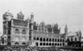
 ビーチ・ホテル(1882-1883年建設、1898年の火事の後に取り壊された)、ガルベストン・ビーチ
 -
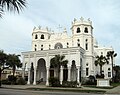
 Bishop's palace, 正面
 -
 Bishop's palace, 側面
 -
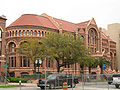 テキサス医科大学、最初の校舎(1891年設立)
 -
 1883-1884年建設
 -
 Stewart Building, 1881-1882年建設
 -
 Ursuline academy, 1891-1895年建設
 -
 Sacred Heart 教会


ガルベストン住民・出身者[編集]
- en:Kay Bailey Hutchison、テキサス州選出アメリカ合衆国上院議員
- ヴァレリー・ペリン、女優
- キャサリン・ヘルモンド、女優
- キング・ヴィダー、映画監督
- ジャック・ジョンソン、プロボクサー、黒人初のボクシング世界ヘビー級チャンピオン
- ジャン・ラフィット、海賊、伝説的・英雄的人物、ガルベストン島に彼の住居 "Maison Rouge" の基礎部分が残っている
- ジョナサン・ポラード、イスラエルのスパイ
- ジョン・マクラーレン、シアトル・マリナーズ監督
- バリー・ホワイト、ソウル歌手
- リアナ・リベラト、女優
姉妹都市[編集]
参照: Sister Cities International, Inc. (SCI):
脚注[編集]
(一)^ ab“U.S. Census Bureau QuickFacts: Galveston city, Texas” (英語). www.census.gov. 2024年1月6日閲覧。
(二)^ “Galveston Island”. web.archive.org (2010年6月26日). 2024年1月6日閲覧。
(三)^ “2019 U.S. Gazetteer Files”. United States Census Bureau. 2024年1月6日閲覧。
(四)^ abMcComb, David G. (1986). Galveston: a history (1st ed ed.). Austin: University of Texas Press. ISBN 978-0-292-72049-7
(五)^ Association, Texas State Historical. “Malhado Island” (英語). Texas State Historical Association. 2024年6月17日閲覧。
(六)^ Association, Texas State Historical. “Aury, Louis Michel” (英語). Texas State Historical Association. 2024年6月17日閲覧。
(七)^ abAssociation, Texas State Historical. “Laffite, Jean” (英語). Texas State Historical Association. 2024年6月17日閲覧。
(八)^ “New Page 1”. web.archive.org (2009年4月17日). 2024年6月17日閲覧。
外部リンク[編集]
- City of Galveston government
- Galveston Chamber of Commerce
- The University of Texas Medical Branch at Galveston
- Texas A&M University at Galveston
- Galveston College
- Galveston Independent School District
- The Galveston County Daily News
| 全般 |
|
|---|---|
| 国立図書館 |
|
| 地理 |
|
| その他 |
|