
ファイル:Texas Congressional Districts, 118th Congress.svg

この SVG ファイルのこの PNG プレビューのサイズ: 739 × 600 ピクセル. その他の解像度: 296 × 240 ピクセル | 592 × 480 ピクセル | 947 × 768 ピクセル | 1,262 × 1,024 ピクセル | 2,524 × 2,048 ピクセル | 1,703 × 1,382 ピクセル。
元のファイル (SVG ファイル、1,703 × 1,382 ピクセル、ファイルサイズ: 6.15メガバイト)
ウィキメディア・コモンズのファイルページにある説明を、以下に表示します。 |
概要
| 解説 |
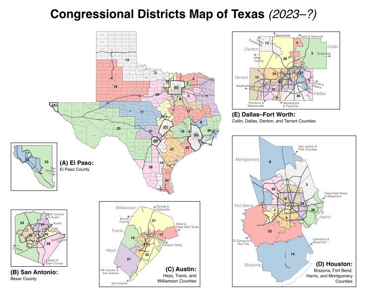
English: Map of the congressional districts of Texas, complemented with counties and primary roads (interstates, state highways, etc.), as well as insets of major metropolitan areas. These congressional districts will be put into effect from 2023 to 2033, following the 2022 US House elections. Among the shapefiles used: https://data.capitol.texas.gov/dataset/b806b39a-4bab-4103-a66a-9c99bcaba490 (congressional districts, released under CC-BY by the Texas Legislative Council), https://www2.census.gov/geo/tiger/GENZ2020/shp/cb_2020_us_county_500k.zip and https://www2.census.gov/geo/tiger/GENZ2020/shp/cb_2020_us_county_within_cd116_500k.zip (counties), https://www.census.gov/cgi-bin/geo/shapefiles/index.php (roads). Made with https://mapshaper.org/ (Mercator projection) and Inkscape (Helvetica font). |
| 日付 | |
| 原典 | 投稿者自身による著作物 |
| 作者 | Twotwofourtysix |
ライセンス
この作品の著作権者である私は、この作品を以下のライセンスで提供します。
このファイルはクリエイティブ・コモンズ 表示-継承 4.0 国際ライセンスのもとに利用を許諾されています。
あなたは以下の条件に従う場合に限り、自由に
●共有 – 本作品を複製、頒布、展示、実演できます。
●再構成 – 二次的著作物を作成できます。
あなたの従うべき条件は以下の通りです。
●表示 – あなたは適切なクレジットを表示し、ライセンスへのリンクを提供し、変更があったらその旨を示さなければなりません。これらは合理的であればどのような方法で行っても構いませんが、許諾者があなたやあなたの利用行為を支持していると示唆するような方法は除きます。
●継承 – もしあなたがこの作品をリミックスしたり、改変したり、加工した場合には、あなたはあなたの貢献部分を元の作品とこれと同一または互換性があるライセンスの下に頒布しなければなりません。
ファイルの履歴
過去の版のファイルを表示するには、その版の日時をクリックしてください。
| 日付と時刻 | サムネイル | 寸法 | 利用者 | コメント | |
|---|---|---|---|---|---|
| 現在の版 | 2022年9月10日 (土) 12:44 | | 1,703 × 1,382 (6.15メガバイト) | Twotwofourtysix | Uploaded own work with UploadWizard |
ファイルの使用状況
以下の 2 ページがこのファイルを使用しています:
グローバルなファイル使用状況
以下に挙げる他のウィキがこの画像を使っています:
- en.wikipedia.org での使用状況
- it.wikipedia.org での使用状況
- simple.wikipedia.org での使用状況
- zh.wikipedia.org での使用状況