
ファイル:USA Hawaii location map.svg

元のファイル (SVG ファイル、1,441 × 935 ピクセル、ファイルサイズ: 31キロバイト)
ウィキメディア・コモンズのファイルページにある説明を、以下に表示します。 |
| 解説 |
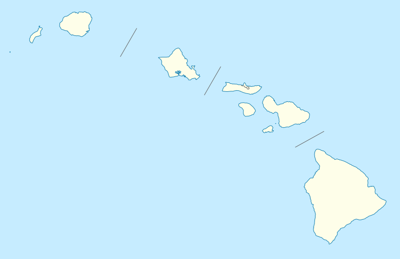
Quadratische Plattkarte, N-S-Streckung 107 %. Geographische Begrenzung der Karte:
Equirectangular projection, N/S stretching 107 %. Geographic limits of the map:
|
|
| 日付 | 09-06-2009 | |
| 原典 |
own work, using
|
|
| 作者 | NordNordWest | |
| 許可 (ファイルの再利用) |
このファイルはクリエイティブ・コモンズ 表示-継承 3.0 ドイツライセンスのもとに利用を許諾されています。
あなたは以下の条件に従う場合に限り、自由に
●共有 – 本作品を複製、頒布、展示、実演できます。
●再構成 – 二次的著作物を作成できます。
あなたの従うべき条件は以下の通りです。
●表示 – あなたは適切なクレジットを表示し、ライセンスへのリンクを提供し、変更があったらその旨を示さなければなりません。これらは合理的であればどのような方法で行っても構いませんが、許諾者があなたやあなたの利用行為を支持していると示唆するような方法は除きます。
●継承 – もしあなたがこの作品をリミックスしたり、改変したり、加工した場合には、あなたはあなたの貢献部分を元の作品とこれと同一または互換性があるライセンスの下に頒布しなければなりません。
 このファイルはクリエイティブ・コモンズ 表示-継承 3.0 ドイツライセンスのもとに利用を許諾されています。
あなたは以下の条件に従う場合に限り、自由に
●共有 – 本作品を複製、頒布、展示、実演できます。
●再構成 – 二次的著作物を作成できます。
あなたの従うべき条件は以下の通りです。
●表示 – あなたは適切なクレジットを表示し、ライセンスへのリンクを提供し、変更があったらその旨を示さなければなりません。これらは合理的であればどのような方法で行っても構いませんが、許諾者があなたやあなたの利用行為を支持していると示唆するような方法は除きます。
●継承 – もしあなたがこの作品をリミックスしたり、改変したり、加工した場合には、あなたはあなたの貢献部分を元の作品とこれと同一または互換性があるライセンスの下に頒布しなければなりません。
|
|
| その他のバージョン |
このファイルの派生的著作物: |
|
| SVG 開発 InfoField |


|
この地図は、ドイツ語版の(地図研究室)で制作、もしくは改善されたものです。更なる改善の為、地図を提案することもできます。
|
ファイルの履歴
過去の版のファイルを表示するには、その版の日時をクリックしてください。
| 日付と時刻 | サムネイル | 寸法 | 利用者 | コメント | |
|---|---|---|---|---|---|
| 現在の版 | 2009年6月13日 (土) 18:36 | | 1,441 × 935 (31キロバイト) | NordNordWest | {{Information |Description= {{de|Positionskarte von Hawaii, USA}} Quadratische Plattkarte, N-S-Streckung 107 %. Geographische Begrenzung der Karte: * N: 22.4° N * S: 18.7° N * W: 160.7° W * O: 154.6° W {{en|Location map of [ |
ファイルの使用状況
以下の 37 ページがこのファイルを使用しています:
- アレクサンダー&ボールドウィン砂糖博物館
- イーストホノルル
- ウォ・ヒン会館
- カフルイ空港
- カポレイ (ハワイ州)
- カメハメハ5世郵便局
- カラウパパ国立歴史公園
- ケアナエ
- ケオケア (マウイ郡)
- コナ国際空港
- コロアの製糖工場跡
- セントアンドリューズ大聖堂 (ホノルル)
- ソニーオープン・イン・ハワイ
- ダニエル・K・イノウエ国際空港
- ハイク (ハワイ州)
- ハワイ出雲大社
- ハワイ大神宮
- ハワイ火山観測所
- ハワイ石鎚神社
- ハワイ金刀比羅神社・ハワイ太宰府天満宮
- パイオニア・イン
- パールハーバー・ヒッカム統合基地
- ヒュンダイ・トーナメント・オブ・チャンピオンズ
- ヒロ国際空港
- フォート・デ・ルッシー
- ホオレフア
- マリア・ラナキラ・カトリック教会
- モクウラ
- ラハイナのバニヤン・ツリー
- ラハイナ・バニヤン・コート・パーク
- ラハイナ歴史地区
- ワイオラ教会
- 若宮稲荷神社 (ハワイ)
- 利用者:桂鷺淵/資料5
- モジュール:Location map/data/Hawaii
- モジュール:Location map/data/USA Hawaii
- モジュール:Location map/data/USA Hawaii/doc
グローバルなファイル使用状況
以下に挙げる他のウィキがこの画像を使っています:
- af.wikipedia.org での使用状況
- an.wikipedia.org での使用状況
- ar.wikipedia.org での使用状況
- ast.wikipedia.org での使用状況
- Archipiélagu de Ḥawai
- Honolulu
- Sablera Lanikai
- Oahu
- Waikiki
- Haleakala
- Mauna Loa
- Observatorios de Mauna Kea
- Cadena de montes somarinos Ḥawai-Emperador
- Mauna Kea
- Pearl Harbor
- Módulu:Mapa de llocalización/datos/Ḥawai
- Módulu:Mapa de llocalización/datos/Ḥawai/usu
- Kilauea
- Wheeler Army Airfield
- Niihau
- Diamond Head (Ḥawai)
- azb.wikipedia.org での使用状況
- کاهیلوئی، هاوایی
- منیل هاوایی
- وایوآینیو، هاوایی
- دیسکاوری هاربور، هاوایی
- ماهیناهینا، هاوایی
- هواولیهوا، هاوایی
- هایکو، هاوایی
- هوناناو، هاوایی
- کینی، هاوایی
- هیلهوماها، هاوایی
- وایکله، هاوایی
- لانیوپوکو، هاوایی
- میلیلانی ماکا، هاوایی
- وست لاک استیتس، هاوایی
- نīنول، هاوایی
- پاوهاو، هاوایی
- پāپاʻالوا، هاوایی
- ʻوالاپوʻ، هاوایی
- وولکانو، هاوایی
- هیلو، هاوایی
- ایشوفیلد باراکس
- کایلوا-کونا، هاوایی
- کاپولئی، هاوایی
- کیلیا، هاوایی
このファイルのグローバル使用状況を表示する。