
トルコの地震一覧


トルコの地震一覧︵トルコのじしんいちらん︶は、トルコにおける地震の年表である。トルコで発生した歴史地震を含む主な地震の記録を年表形式で記載する。
解説[編集]
テクトニクス的に、トルコはユーラシアプレート、アフリカプレート、アラビアプレートが複雑に衝突している大陸衝突の活発な地域である。国の大部分は北アナトリア断層と東アナトリア断層という二つの横ずれ断層に囲まれた小さなアナトリアプレートの上にある。国の西側はエーゲ海の南西に広がっていくヘレニックアークに起因する伸張テクトニクス帯の影響を受ける。東側は、ザグロス褶曲衝上帯︵en:Zagros fold and thrust belt︶の西端にある。-
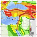 世界地震ハザード評価プログラム(GSHAP)によるトルコで、今後50年間に表面最大加速度的に地震が所定の露出時間の間の揺れが10%以上の確率で生じる可能性を表した震災危険度マップ
 -
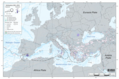 地中海周辺のM5.5以上の地震(1900-2016)


トルコの地震対策[編集]
1999年のイズミット地震後、建築物の耐震基準が更新され、地震対策にかかる費用対策として地震税が設けられ、2007年には耐震基準が引き上げられた[1]。これは日本並みとも評される耐震基準であったが汚職や賄賂で骨抜きであったのではないかという指摘もされている[2][3][4]。
地震の一覧[編集]
- この一覧は未完成です。加筆、訂正して下さる協力者を求めています。

| 日付 | 時刻 | 場所 | 緯度 | 経度 | 死者 | 規模(震度) | 備考 | 出典 |
|---|---|---|---|---|---|---|---|---|
| 17年 | n/a | フィラデルフィア (アラシェヒル) | 38.21 | 28.31 | n/a | n/a | 「リュディア地震」を参照
|
[5] |
| 115年12月13日 | アンティオキア | 36.1 | 36.1 | ~260,000 | 7.5 Ms | 「アンティオキア地震 (115年)」を参照
|
[6] | |
| 141年 (または 142年) | リュキア, カリア, ドデカネス諸島 | 36.7 | 28.0 | n/a | (VIII) | ロドス島に深刻な津波を引き起こした; 「リュキア地震」を参照
|
[7] | |
| 262年 | アナトリアの西と南の海岸 | 36.5 | 27.8 | n/a | (IX) | エフェソスの多くの建物を壊し、沿岸都市に津波を引き起こした; 「南西アナトリア地震」を参照
|
[8] | |
| 526年5月19日 | アンティオキア | 250,000 | (VIII) | アンティオキア市に甚大な被害を起こし、大きく人口を減少させた. 「アンティオキア地震 (526年)」を参照
|
[9] | |||
| 557年12月14日 | 深夜直前 | コンスタンティノープル | 40.9 | 28.7 | n/a | (X) | コンスタンティノープルは地震によって「ほぼ完全に更地になった」。 「コンスタンティノープル地震 (557年)」を参照
|
[10] |
| 1268年 | キリキア, アナトリア半島 | 37.5 | 35.5 | 60,000 | ~7 | 「キリキア地震」を参照
|
– | |
| 1509年9月10日 | コンスタンティノープル | 40.9 | 28.7 | 10,000 | 7.2 Mw | – | ||
| 1653年2月23日 | スミュルナ(イズミル古名) | 38.2 | 28.2 | 2,500 | 7.5 | 「東スミュルナ地震」を参照
|
[11] | |
| 1668年8月17日 | アナトリア半島 | 40 | 36 | 8,000 | 8 | 「北アナトリア地震 (1668年)」を参照
|
USGS | |
| 1688年7月10日 | 11時45分 | スミュルナ(イズミル古名) | 38.4 | 26.9 | 16,000 | 7.0 Ms | 「スミュルナ地震 (1688年)」を参照
|
[12] |
| 1719年5月25日 | イズミット | 40.7 | 29.8 | 6,000 | 7.4 | 「イズミット地震 (1719年)」を参照
|
||
| 1855年2月28日 | 1時00分 | ブルサ | 40.2 | 29.1 | 1,900 | 6.7 | 「ブルサ地震」を参照
|
[13] |
| 1859年6月2日 | 10時30分 | エルズルム | 39.9 | 41.3 | 15,000 | 6.1 Ms | 「エルズルム地震」を参照
|
[14] |
| 1881年4月3日 | 11時30分 | ヒオス島, チェシュメ, Alaçatı | 38.25 | 26.25 | 7,866 | 7.3 Mw | [15] | |
| 1894年7月10日 | 12時24分 | イズミット湾 | 40.73 | 29.25 | 1,300 | 7.0 | 「イスタンブール地震」を参照
|
[16] |
| 1903年4月29日 | 1時46分 (現地時間) | Malazgirt | 39.14 | 42.65 | 600 | 6.7 Ms | [17][18] | |
| 1912年8月9日 | 3時29分 (現地時間) | Mürefte | 40.75 | 27.2 | 216 | 7.3 MS | [17][18] | |
| 1914年10月4日 | 0時7分 (現地時間) | ブルドゥル | 37.82 | 30.27 | 300 | 6.9 MS | 「ブルドゥル地震」を参照
|
[17][18] |
| 1924年9月13日 | 16時34分 (現地時間) | Horasan | 40.0 | 42.1 | 60 | 6.8 | [17][18] | |
| 1926年10月22日 | 21:59 (現地時間) | カルス | 40.7 | 43.7 | 360 | 6.0 Ms | 「カルス地震」を参照
|
[19] |
| 1928年3月31日 | 2時29分 (現地時間) | スミュルナ(イズミル古名) | 38.5 | 28.0 | 50 | 6.5 MS | 前日にM6.2の前震が起きていた可能性あり | [17][18] |
| 1929年5月18日 | 08:37 (現地時間) | スシェフリ | 40.2 | 37.9 | 64 | 6.1 | Ms | [17][18] |
| 1930年5月7日 | 0時34分 (現地時間) | ハッキャリ | 38.1 | 44.7 | 2,514 | 7.2–7.5 Ms | [20] | |
| 1935年1月4日 | 16時41分 (現地時間) | Erdek | 40.4 | 27.5 | 5 | 6.4 Ms | [17][18] | |
| 1938年4月19日 | 12:59 (現地時間) | クルシェヒル | 39.1 | 34.0 | 160 | 6.6 MS | 「1938年クルシェヒル地震」を参照
|
[17][18] |
| 1939年9月22日 | 02:36 (現地時間) | Dikili | 39.1 | 26.8 | 60 | 6.6 MS | [17][18] | |
| 1939年12月26日 | 23時57分 | エルジンジャン | 39.77 | 39.53 | 32,700 | 7.8 MS | 「エルジンジャン地震 (1939年)」を参照
|
USGS |
| 1942年11月15日 | 19時1分 (現地時間) | Bigadiç | 39.2 | 28.2 | 16 | 6.1 MS | [17][18] | |
| 1942年12月20日 | 14時3分 | Erbaa | 40.87 | 36.47 | 3000 | 7.0 | [21] | |
| 1943年6月20日 | 17時32分 (現地時間) | Hendek | 40.6 | 30.5 | 336 | 6.6 MS | [17][18] | |
| 1943年11月26日 | 22:24 | Ladik | 41.05 | 33.72 | 4000 | 7.4 | [21] | |
| 1944年2月1日 | 3時25分 | Gerede | 40.8 | 32.2 | 3959 | 7.5 | [21] | |
| 1944年10月6日 | 4時34分 (現地時間) | アイワルク | 39.37 | 26.53 | 30 | 6.8 MS | [17][18] | |
| 1949年8月17日 | Karlıova | 39.54 | 40.57 | 450 | 6.8 | [21] | ||
| 1951年8月13日 | 18:36 | Kurşunlu | 40.88 | 32.87 | 50 | 6.9 | [21] | |
| 1953年5月18日 | 21時6分 (現地時間) | Yenice | 40.02 | 27.53 | 265 | 7.2 MS | [17][18] | |
| 1955年7月16日 | 9時7分 (現地時間) | Söke | 37.55 | 27.05 | 23 | 6.8 MS | [17][18] | |
| 1957年4月25日 | 4時25分 (現地時間) | フェトヒイェ | 36.5 | 28.6 | 67 | 7.1 MS | 「フェトヒイェ地震」を参照
|
[17][18] |
| 1957年5月26日 | 6時36分 | Abant | 40.67 | 31.00 | 52 | 7.1 | [21] | |
| 1964年10月6日 | 16時31分 (現地時間) | Manyas | 40.1 | 27.93 | 23 | 7.0 MS | [17][18] | |
| 1966年8月19日 | 12時23分 | Varto | 39.17 | 41.56 | 2396 | 6.7 | [21] | |
| 1967年7月22日 | 16時56分 | Mudurnu | 40.67 | 30.69 | 89 | 7.2 | [21] | |
| 1968年9月3日 | 10時19分 (現地時間) | Bartın | 41.79 | 32.31 | 29 | 6.5 MS | [17][18] | |
| 1969年5月28日 | 3時48分 (現地時間) | Alaşehir | 38.5 | 28.4 | 53 | 6.5 MS | [17][18] | |
| 1970年5月28日 | 23時2分 (現地時間) | Gediz | 39.2 | 29.5 | 1086 | 7.2 MS | [17][18] | |
| 1971年5月22日 | 16時44分 | ビンギョル | 38.83 | 40.52 | 1000+ | 6.9 | [22] | |
| 1975年9月6日 | 12時20分 (現地時間) | Lice | 38.5 | 40.7 | 2385 | 6.6 MS | [17][18] | |
| 1976年11月24日 | 14時22分 (現地時間) | en:Muradiye | 39.12 | 44.03 | 3840 | 7.5 MS | [17][18] | |
| 1983年10月30日 | 7時12分 (現地時間) | エルズルム | 40.33 | 42.19 | 1155 | 6.9 MS | [17][18] | |
| 1992年5月13日 | 17時18分 | エルズィンジャン | 39.70 | 39.69 | 498 | 6.8 | 「エルジンジャン地震 (1992年)」を参照
|
[23] |
| 1995年10月1日 | 17時57分 (現地時間) | ディナール | 38.06 | 30.13 | 90 | 6.1 MS | 「ディナール地震」を参照
|
[17][18] |
| 1998年6月27日 | 16時55分 (現地時間) | ジェイハン | 36.88 | 35.31 | 146 | 6.2 MS | [17][18] | |
| 1999年8月17日 | 03:02 (現地時間) | イズミット | 40.77 | 30 | 17,127 | 7.6 | M (PDE Monthly Listing) An official Turkish estimate of October 19, 1999, placed the toll at 17,127 killed and 43,959 injured, but many sources suggest the actual figure may have been closer to 45,000 dead and a similar number injured.;[24] 「イズミット地震 (1999年)」を参照
|
USGS |
| 1999年11月12日 | 18時57分 (現地時間) | デュズジェ | 40.75 | 31.16 | 894 | 7.2 M | (PDE Monthly Listing); 「デュズジェ地震」を参照
|
USGS |
| 2002年2月3日 | 7時11分 | アフィヨンカラヒサール県 | 38.573 | 31.271 | 44 | 6.5 Mw | (HRV) | |
| 2003年1月27日 | 5時26分 | ピュリュミュル | 39.46 | 39.79 | 1 | 6.1 Mw | (HRV, USGS) | USGS |
| 2003年5月1日 | 0時27分 | ビンギョル | 39.01 | 40.46 | 177 | 6.4 Mw | (HRV, USGS); 「ビンギョル地震 (2003年)」を参照
|
|
| 2010年5月8日 | 2時32分 | エラズー県 | 38.87 | 39.99 | 41 | 6.1 Mw | (HRV); 「エラズー県地震」を参照
|
[25] |
| 2011年5月19日 | 23時15分 | キュタヒヤ県 | 39.14 | 29.07 | 2 | 5.8 Mw | (HRV); 「トルコ西部地震」を参照
|
|
| 2011年10月23日 | 13時41分 | ヴァン県 | 38.63 | 43.49 | 604 | 7.2 Mw | (HRV); 「トルコ東部地震 (2011年10月)」を参照
|
[26] |
| 2020年10月30日 | 11時51分 | エーゲ海海域 | 「エーゲ海地震」を参照
|
|||||
| 2023年2月6日 | 10時17分 | ガズィアンテプ県 | 「トルコ・シリア地震」を参照
|
出典[編集]
(一)^ “Turkey: New building code for earthquake resilience” (英語). www.preventionweb.net. 2023年2月18日閲覧。
(二)^ Baysan, Lauren Said-Moorhouse,Isil Sariyuce,Zeena Saifi,Reyhan (2023年2月8日). “Emotions run high in Turkey amid questions over state response to deadly quake” (英語). CNN. 2023年2月18日閲覧。
(三)^ “焦点‥﹁日本並み﹂新耐震基準生きず トルコ、﹁恩赦﹂で抜け道も”. 毎日新聞. 2023年2月18日閲覧。
(四)^ “焦点‥﹁腐った建物﹂と骨抜き規制、トルコ地震で建物多数倒壊”. Reuters (2023年2月16日). 2023年2月18日閲覧。
(五)^ The Internet Classics Archive. “Tacitus Annales Book 2, 47”. 2013年6月21日閲覧。
(六)^ National Geophysical Data Center. “Comments for the Significant Earthquake”. 2011年10月19日閲覧。
(七)^ “Comments for the tsunami event”. Significant Earthquake Database. National Geophysical Data Center. 2015年2月8日閲覧。
(八)^ “Turkey: S Coasts; Libya: Comments for the Earthquake Event”. Significant Earthquake Database. National Geophysical Data Center. 2016年10月4日閲覧。
(九)^ プロコピオス, II.14.6; sources based on John of Ephesus
(十)^ Agathias; Frendo, Joseph D. (1975), The histories, Walter de Gruyter, ISBN 978-3-11-003357-1
(11)^ NGDC. “Comments for the 1653 Earthquake”. 2011年2月1日閲覧。
(12)^ NGDC. “Comments for the 1688 Earthquake”. 2011年2月1日閲覧。
(13)^ NGDC. “Comments for the 1855 Earthquake”. 2011年2月2日閲覧。
(14)^ NGDC. “Comments for the 1859 Earthquake”. 2011年2月1日閲覧。
(15)^ NGDC. “Comments for the 1881 Earthquake”. 2011年2月2日閲覧。
(16)^ Ambraseys, N. (January 2001). “The earthquake of 10 July 1894 in the Gulf of Izmit (Turkey) and its relation to the earthquake of 17 August 1999”. Journal of Seismology (Kluwer Academic Publishers) 5 (1): 117–128. doi:10.1023/A:1009871605267. ISSN 1573-157X.
(17)^ abcdefghijklmnopqrstuvwxBogazici University Kandilli Observatory and Earthquake Research Institute National Earthquake Monitoring Center (NEMC) List of earthquakes 1900–2004 (In Turkish)
(18)^ abcdefghijklmnopqrstuvwxIISEENET (Information Network of Earthquake disaster Prevention Technologies) – Search Page
(19)^ NGDC. “Comments for the 1926 Earthquake”. 2011年2月3日閲覧。
(20)^ NGDC. “Comments for the 1930 Earthquake”. 2011年2月3日閲覧。
(21)^ abcdefghToksoz, M.N., Shakal, A.F. & Michael, A.J. 1979. Space-Time Migration of Earthquakes Along the North Anatolian Fault Zone and Seismic Gaps. Pageophys, 117, 1258–1270.
(22)^ USGS list of earthquakes with 1,000 or More Deaths since 1900 Archived 2008-10-11 at the Wayback Machine.
(23)^ Bernard, P., Gariel, J-C. & Dorbath L. 1997. Fault location and rupture kinematics of the magnitude 6.8, 1992 Erzincan earthquake, Turkey, from strong ground motion and regional records. Bulletin Seismological Society of America, 87, 1230–1243.
(24)^ Marza, Vasile I. (2004). On the death toll of the 1999 Izmit (Turkey) major earthquake. ESC General Assembly Papers, Potsdam: European Seismological Commission. オリジナルの2008-04-09時点におけるアーカイブ。
(25)^ USGS. “Magnitude 6.1 – eastern Turkey”. 2010年3月11日時点のオリジナルよりアーカイブ。2017年7月29日閲覧。
(26)^ USGS. “Magnitude 7.2 – EASTERN TURKEY”. 2011年10月24日時点のオリジナルよりアーカイブ。2017年7月29日閲覧。
関連項目[編集]
- ギリシャ・トルコ地震外交 - 1999年の夏に発生した地震によって両国間の外交的な緊張が緩和し、両国間が互助の為に動いた。
- 災害緊急事態対策庁(AFAD) ‐ トルコの災害対策政府機関
- 周辺国の地震一覧
- ギリシャの地震一覧
- コーカサス地域の地震一覧(トルコより東側の地域の地震一覧)
- イランの地震一覧
- 東ヨーロッパの地震一覧
| 典拠管理データベース: 国立図書館 |
|
|---|