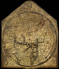
ヘレフォード図
表示


ヘレフォード図︵ヘレフォードず、Hereford Mappa Mundi︶は、1300年頃に作成された中世ヨーロッパの思想を反映したマッパ・ムンディを代表する世界地図。イギリスのヘレフォードにあるヘレフォード大聖堂所蔵。現存するマッパ・ムンディの中では最大のものである。
概要[編集]
この地図は﹁ホルディンガムとラフォードのリチャード﹂︵Richard of Haldingham and Lafford︶という人物の作とされ、彼は別名Richard de Bello[1]またはprebend of Lafford in Lincoln Cathedralとも[2]呼ばれている。 この地図は縦158cm×横133cm[3]︵165cm×134cmとも[4]︶のヴェラム︵上質皮紙、羊皮紙[3]とも子牛の皮[4]ともある︶に、黒と補助的に赤や金色やインクを用いて描かれ、海洋部は青と緑、例外的に紅海︵とペルシャ湾︶だけは赤く塗られている。奇妙な事に、ヨーロッパとアフリカの表示がひっくり返っており、本来ヨーロッパである場所は赤と金の文字で﹁Africa﹂と書かれ、逆もまた同様となっている。 もとは三連祭壇画の中央部分であり、1780年ごろの記録では左のパネルには大天使ガブリエル、右のパネルには受胎告知があったとされるが現存しない[5]。パネルのオーク材の伐採時期の推定、ヴェラムに使われた仔牛皮の加工時期の推定、文言の書体分析の推定では、1290年代前後であることが共通しており、地図製作年代は1300年ごろと推定される。作成の目的[編集]
ヘレフォード図は後期マッパ・ムンディであるグレートマップに分類され、東方向が上にありエルサレムを中心に据えたTO図の基本形式を踏襲している。そのため、必ずしも作成当時の地理知識を反映しておらず、例えば、モンゴル帝国のモンケ・ハーンと謁見したウィリアム・ルブルックによる1255年の報告に反して、カスピ海が外洋と繋がって描かれている。1296年に製作された、ヘレフォード図よりも古い羅針儀海図[6]︵ポルトラーノ、Portolan charts︶では、この点は正確に記されている。 古代ギリシャやローマの概念(en)にあった地球球体説は中世ヨーロッパにおいても健在であり、ヘレフォード図を含むTO図の存在が、必ずしも当時のヨーロッパ人が地球は平面(en)と認識していた証拠にはならない。このヘレフォード図は、かつてはヘレフォード大聖堂の祭壇の後ろに掲げられていたという点から、ステンドグラスと同じくキリスト教を視覚的に伝えるための教材であり、また一種の百科事典でもあったと考えられる[3]。 上記の目的を反映して、地図内には大きく分けて三つの要素が記入されている。一つ目は地図本来の目的である地理であり、当時のヨーロッパが知りえた都市192箇所[4]や有力な河川、TO図形式に囚われてはいるが地中海とその周辺にあたる海洋部が描かれている。二つ目は聖書神話にある物語が図案化し記入されている。これは、焼失したエプストルフの世界図(en)にも見られる[3]。三つ目は﹁化物世界誌﹂[7]とも呼ばれる中世ヨーロッパ空想がもたらした様々な怪物・怪人たちであり、特に遠方に多く書き込まれている。これら各要素には解説文が付けられているものが多い。[4]地図の各要素[編集]
本項は特に脚注が無い場合は、英語版および﹃聖書 VS. 世界史﹄[4]を出典としている。
地理[編集]
(1) エルサレム TO図の形式に則り、地図の中心に描かれる。 (2) 中国 ﹁セリカ﹂と表記されている。砂漠を越えて進むと最初に中国人と出会い、彼らの国から絹が送られてくるとある。ヘレフォード図では実体にそぐわない小地域でしかない。 (3) ガンジス川 下流域に形成される広大な三角州も描写されている。ここから、(4) タファナ島と四つの小島‐(5) インダス川とチグリス川に当たる区域がインドになる。 (4) タファナ島と四つの小島 タファナ(Island of Taphana)とはスリランカ、またはスマトラ島を示しているという説もある。古代ギリシアやローマでは﹁タプロバネ﹂(Taprobane)と呼ばれていた。四つの小島はクリュセ(Chryse)・アルギュラ(Argyra)・オフィル(Ophir)・フロンディシア(Frondisia)を指す。それぞれが実在するどの島と対応しているかは不明だが、オフィル島は旧約聖書において黄金を産出する場所と記されている[8]。 (5) インダス川とチグリス川この節の加筆が望まれています。 |
この節の加筆が望まれています。 |
この節の加筆が望まれています。 |
(11) ナイル川上流
もしくは赤道域にある未知の海洋を表し、その先にある陸地は対蹠地とも定義される未踏の大陸を示しているともされる。
(12) アゾフ海
流れ込むドン川とクバン川も描写されている。
(13) コンスタンティノープル
現在のイスタンブール。左側︵北︶にはドナウ・デルタがある。
(14) エーゲ海
この節の加筆が望まれています。 |
(15) アレクサンドリア
ナイル川の三角州は非常に大きく描かれており、アレクサンドリアの大灯台も記入されている。
(16) ノルウェー
伝説に基づいた描写である。﹁水の上を走る﹂と説明されながら、スキーを履いた人物画がある。
(17) プラハ
この節の加筆が望まれています。 |
(18) ギリシャ
オリンポス山、アテネ、コリントスが記述されている。
(19) クレタ島
ミノタウロスの迷宮︵クノッソス宮殿︶も描写されている。
(20) イタリア半島
アドリア海とティレニア海に挟まれ、中心に記されたローマには、典型的なヘクサメター︵英‥hexameter、六脚韻︶で﹁Roma caput mundi tenet orbis frena rotundi︵ローマ、世界に冠たる、世界の手綱を統べる地︶﹂と賞賛の言葉が添えられている。

グレートブリテン島の拡大図︵19世紀の模写[3]︶
(21) シチリア島
ローマの対岸にはカルタゴも描かれている。
(22) スコットランド

この節の加筆が望まれています。 |
この節の加筆が望まれています。 |
この節の加筆が望まれています。 |
この節の加筆が望まれています。 |
この節の加筆が望まれています。 |
聖書神話[編集]

この節の加筆が望まれています。 |
(5) 塩の柱
ソドムとゴモラから逃げる際、振り返ったため塩の柱となったロトの妻。
(6) ソドムとゴモラ
死海に浮かぶように二つの都市が描かれている。
(7) ノアの方舟
アララト山に相当する場所に描かれている。
(8) 出エジプト
モーセに率いられたイスラエル人の行程。ラメセスを発ちエリコまで続く道中、紅海上を渡る部分がある。
(9) ヨセフの穀倉
ピラミッドの事。当時これは、エジプト宰相だったヨセフが飢饉に備えて建てた蔵だと考えられていた。
(10) アレクサンドロスの陣営
アレクサンドロス・ロマンスも参照の事。
(11) ヘラクレスの柱
ヘラクレスが建てたという、世界の端を示す2本の柱。イベリア半島のジブラルタルの岩山と、対岸のスペイン領セウタにあるアビラ山と見なされている[9]が、ヘレフォード図では海峡の真中にある島のようなところに平行した2本の線︵柱︶として描かれている。

﹁化物世界観﹂要素
(1) ヒッポポデス
馬の足を持つ人類。
(2) スキアポデス
大きな一本足を持つ人類。素早く走ることができ、休息する際にはその足を高く掲げ、日陰を作るという。
(3) 巨人
犬の顔と尻尾を持つ巨人。
(4) 長耳人
長く大きな耳たぶを持ち、寒い時にはそれを身体に巻きつけて暖を取るという。描かれている場所は中国沖の島であり現在の日本に相当するが、当時のヨーロッパ人が日本列島を認識していた証拠は無い。
(5) フン族
化物世界誌[編集]

この節の加筆が望まれています。 |
この節の加筆が望まれています。 |
この節の加筆が望まれています。 |
この節の加筆が望まれています。 |
(9) ガンギネス
口を持たず、リンゴのにおいだけで生きる種族。リンゴ以外のにおいを嗅ぐと死ぬとされる。
(10) ゴグ・マゴグ
ともに北端の、閉じ込められた地に住む民族の名とされる。旧約聖書では終末の時に悪魔サタンの手先として現われ、殺戮に明け暮れると描写されている[10]。
(11) キコーネス
頭と脚が鳥の形をした人類。別名コウノトリ人。
(12) マンティコラ
人面獅子身の凶暴な怪物。身体は赤く、サソリの尾を持つ。
(13) グリフィン
この節の加筆が望まれています。 |
この節の加筆が望まれています。 |
(15) アンバリ
耳が無く、よじれた脚を持つ人類。
(16) アリマスピ
またはアリマスポイ人(en)。一つ目の種族。グリフィンが守る黄金を奪うべく戦っている。
(17) エアレ
馬の体、象の尾、山羊の顎、巨大な二本の角を前後に一本ずつ向け、前向きの角のみで戦う動物。
(18) 大唇人
巨大な唇も持つ人類。陽の光を唇を突き出して防ぐとされる。
(19) 口細人
一つ目、一本足の人類。口が小さいためストローで飲む液体だけから栄養を取る。
(20) プシュリ族
妻の貞操を試すため、新生児を蛇に与える習慣を持つ民族。嫡出の赤ん坊には蛇がまきつかないとされる[11]。
(21) バジリスク
翼や足を持たず、蛇の尾を持つ怪鳥の姿で描かれている[11]。
(22) ブレミエ
頭が無く、胸部に眼と口を持つ人類。凶暴な食人族とされる。このような頭が無い描写は、野蛮性と凶暴性を象徴していると言われる[11]。
(23) トログロデュテス
別名は穴居人。穴に住み、蛇やトカゲを食すとされる。図版では捕らえるために猛獣の背に乗っている。カール・フォン・リンネの﹃自然の体系﹄(Systema Naturae、1735年出版の初版)ではヒトとサルの中間種と定義され、現在のチンパンジーの学名であるパン・トログロデュテス(Pan troglodytes)の元となっている。
(24) 海岸エチオピア人
表記はエチオピアだが、現在のエチオピアとは全く関連しない場所に描かれている。四つの眼を持ち、これはアフリカ人の視力の高さを象徴していると言われる[11]。
(25) アグリオファギ人
ヒョウとライオンだけを食べるとされる民族[11]。
