J u m p t o c o n t e n t
M a i n m e n u
M a i n m e n u
N a v i g a t i o n
● M a i n p a g e ● C o n t e n t s ● C u r r e n t e v e n t s ● R a n d o m a r t i c l e ● A b o u t W i k i p e d i a ● C o n t a c t u s ● D o n a t e
C o n t r i b u t e
● H e l p ● L e a r n t o e d i t ● C o m m u n i t y p o r t a l ● R e c e n t c h a n g e s ● U p l o a d f i l e
S e a r c h
Search
A p p e a r a n c e
● C r e a t e a c c o u n t ● L o g i n
P e r s o n a l t o o l s
● C r e a t e a c c o u n t ● L o g i n
P a g e s f o r l o g g e d o u t e d i t o r s l e a r n m o r e ● C o n t r i b u t i o n s ● T a l k
( T o p )
1 H i s t o r y
T o g g l e H i s t o r y s u b s e c t i o n
1 . 1 O t t o m a n e r a
1 . 2 B r i t i s h M a n d a t e e r a
1 . 3 J o r d a n i a n e r a
1 . 4 P o s t - 1 9 6 7
2 R e f e r e n c e s
3 B i b l i o g r a p h y
4 E x t e r n a l l i n k s
T o g g l e t h e t a b l e o f c o n t e n t s
A l - A t t a r a
8 l a n g u a g e s
● ا ل ع ر ب ي ة ● C a t a l à ● E u s k a r a ● ف ا ر س ی ● F r a n ç a i s ● م ص ر ى ● N o r s k n y n o r s k ● P o l s k i
E d i t l i n k s
● A r t i c l e ● T a l k
E n g l i s h
● R e a d ● E d i t ● V i e w h i s t o r y
T o o l s
T o o l s
A c t i o n s
● R e a d ● E d i t ● V i e w h i s t o r y
G e n e r a l
● W h a t l i n k s h e r e ● R e l a t e d c h a n g e s ● U p l o a d f i l e ● S p e c i a l p a g e s ● P e r m a n e n t l i n k ● P a g e i n f o r m a t i o n ● C i t e t h i s p a g e ● G e t s h o r t e n e d U R L ● D o w n l o a d Q R c o d e ● W i k i d a t a i t e m
P r i n t / e x p o r t
● D o w n l o a d a s P D F ● P r i n t a b l e v e r s i o n
I n o t h e r p r o j e c t s
● W i k i m e d i a C o m m o n s
A p p e a r a n c e
C o o r d i n a t e s : 3 2 ° 1 9 ′ 35 ″ N 3 5 ° 0 9 ′ 42 ″ E / 3 2 . 3 2 6 3 9 ° N 3 5 . 1 6 1 6 7 ° E / 32.32639; 35.16167
F r o m W i k i p e d i a , t h e f r e e e n c y c l o p e d i a
T h i s i s t h e c u r r e n t r e v i s i o n o f t h i s p a g e , a s e d i t e d b y J o h n o f R e a d i n g ( t a l k | c o n t r i b s ) at 1 4 : 2 9 , 1 1 F e b r u a r y 2 0 2 4 . T h e p r e s e n t a d d r e s s ( U R L ) i s a p e r m a n e n t l i n k t o t h i s v e r s i o n . ( d i f f ) ← P r e v i o u s r e v i s i o n | L a t e s t r e v i s i o n ( d i f f ) | N e w e r r e v i s i o n → ( d i f f )
For the village in the Ramallah and al-Bireh Governorate, see
'Atara .
Municipality type D in Jenin, State of Palestine
Al-Attara (Arabic : العطارة ) is a Palestinian village in the Jenin Governorate of Palestine , in the northwestern area of the West Bank , located 15 kilometers southwest of Jenin . According to the Palestinian Central Bureau of Statistics , the village had a population of 1,072 inhabitants in mid-year 2006 and 1,244 by 2017.[1] [3]
History [ edit ]
Pottery sherds from the late Roman , Byzantine and early Islamic periods have been found here.[4]
According to SWP : "This place is mentioned in the Onomasticon (s. v. Atharoth ) as a city of Ephraim , north of Sebaste , and 4 miles from it. The distance is exact."[5]
In Crusader sources it was called Lathara .[4]
In 1140, Ussama , a Moslem traveller, mentioned Al-Attara together with nearby Silat ad-Dhahr .[4]
In 1178, it was attacked by Bedouin , but withstood the attack.[4]
Ottoman era [ edit ]
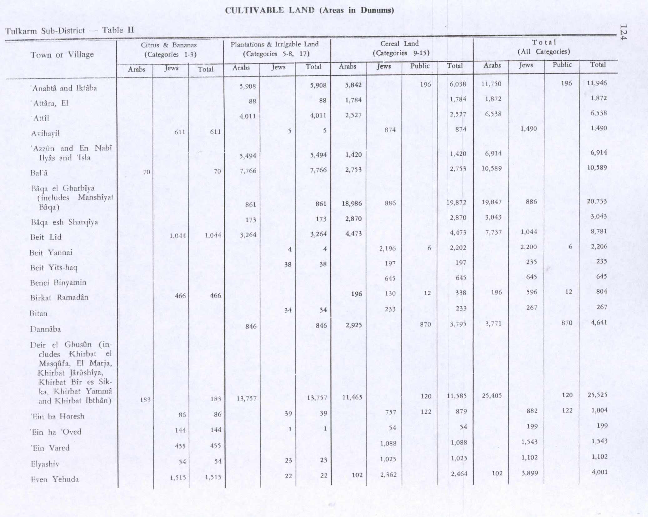
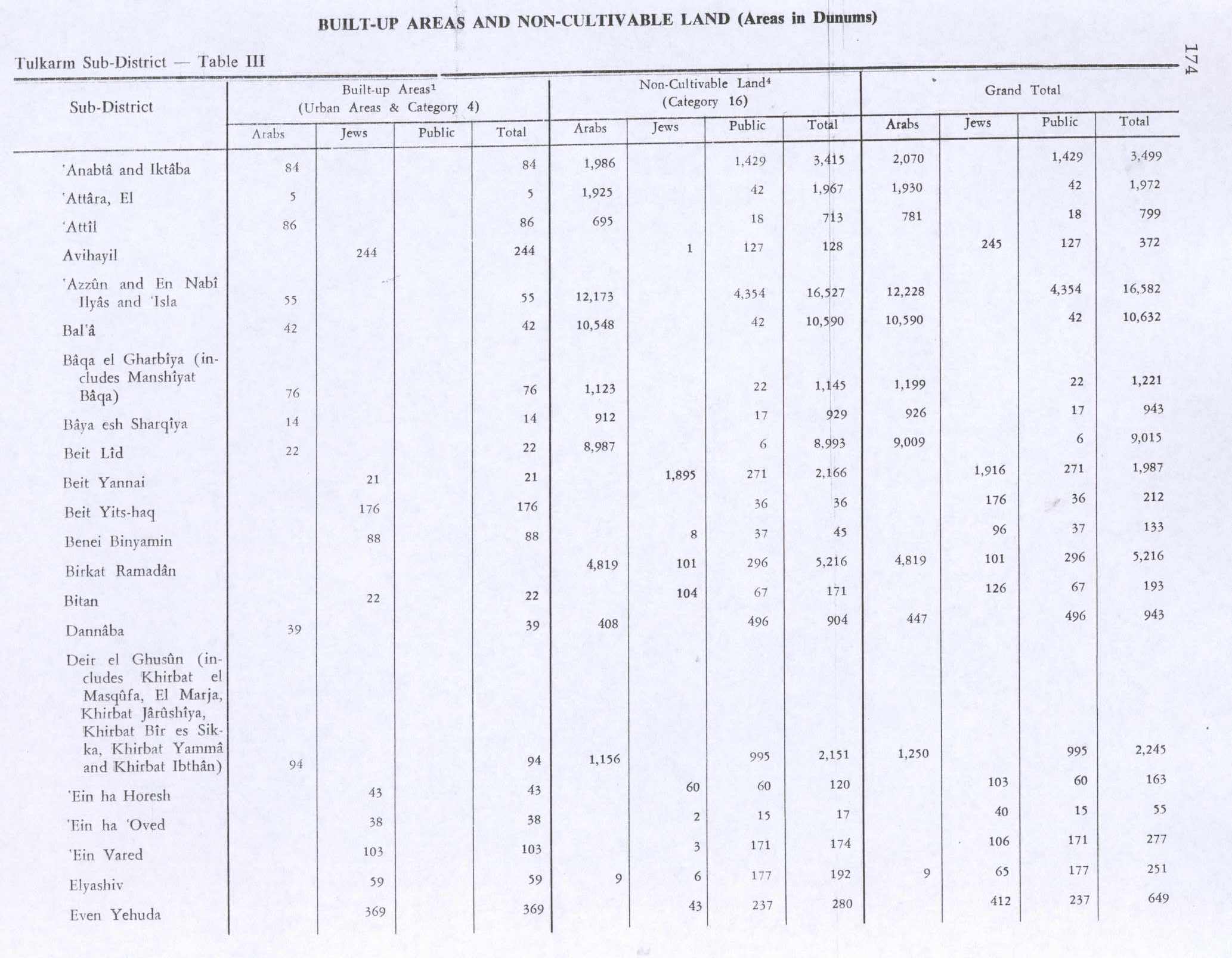
Al-Attara, like all of Palestine , was incorporated into the Ottoman Empire in 1517. About 10% of the pottery sherds found in the village date back to this period.[4] tax registers , Al-Attara was listed as an entirely Muslim village called 'Attara , and had a population of 12 families and 2 bachelors. It was located in the nahiya liwa of Nablus . The inhabitants paid a fixed tax rate of 33,3% on agricultural products, including wheat, barley, summer crops, olive trees, and goats and/or beehives, in addition to occasional revenues and a tax on people from the Nablus area, a total of 5,000 akçe .[6]
A fortress, dating from the 16th—17th century, is visible in the centre of the village.[4]
In 1870, Victor Guérin noted it as a poor village, but one which had succeeded an ancient place.[7]
In 1870/1871 (1288 AH nahiya [8]
In 1882, the PEF 's Survey of Western Palestine well on the west."[5]
British Mandate era [ edit ]
In the 1922 census of Palestine conducted by the British Mandate authorities , Al-Attara had a population of 164 Muslims,[9] 1931 census to 193 Muslims, in 51 houses.[10]
In the 1945 statistics , the population of Al-Attara was 250 Muslims,[11] dunams of land according to an official land and population survey.[12] [13] [14]
Jordanian era [ edit ]
After the 1948 Arab–Israeli War and the 1949 Armistice Agreements , Al-Attara came under Jordanian rule .
The Jordanian census of 1961 found 388 inhabitants in Al-Attara.[15]
Post-1967 [ edit ]
Since the Six-Day War in 1967, Al-Attara has been under Israeli occupation .
References [ edit ]
^ Palmer, 1881, p. 179
^ Projected Mid -Year Population for Jenin Governorate by Locality 2004- 2006 Archived 2008-09-20 at the Wayback Machine Palestinian Central Bureau of Statistics
^ a b c d e f Zertal, 2004, pp. 271 -2
^ a b Conder and Kitchener, 1882, SWP II, p. 154
^ Hütteroth and Abdulfattah, 1977, p. 129
^ Guérin, 1875, pp. 214 -215
^ Grossman, David (2004). Arab Demography and Early Jewish Settlement in Palestine . Jerusalem: Magnes Press. p. 254.
^ Barron, 1923, Table XI, Sub-district of Tulkarm, p. 27
^ Mills, 1932, p.53
^ Government of Palestine, Department of Statistics, 1945, p. 20
^ Government of Palestine, Department of Statistics. Village Statistics, April, 1945. Quoted in Hadawi, 1970, p. 74
^ Government of Palestine, Department of Statistics. Village Statistics, April, 1945. Quoted in Hadawi, 1970, p. 124
^ Government of Palestine, Department of Statistics. Village Statistics, April, 1945. Quoted in Hadawi, 1970, p. 174
^ Government of Jordan, 1964, p. 25
Bibliography [ edit ]
Conder, C.R. ; Kitchener, H.H. (1882). The Survey of Western Palestine: Memoirs of the Topography, Orography, Hydrography, and Archaeology Committee of the Palestine Exploration Fund .
Government of Jordan, Department of Statistics (1964). First Census of Population and Housing. Volume I: Final Tables; General Characteristics of the Population (PDF) .
Government of Palestine, Department of Statistics (1945). Village Statistics, April, 1945
Guérin, V. (1875). Description Géographique Historique et Archéologique de la Palestine
Hadawi, S. (1970). Village Statistics of 1945: A Classification of Land and Area ownership in Palestine the original on 2018-12-08. Retrieved 2014-08-17 .
Hütteroth, Wolf-Dieter; Abdulfattah, Kamal (1977). Historical Geography of Palestine, Transjordan and Southern Syria in the Late 16th Century ISBN 3-920405-41-2
Mills, E., ed. (1932). Census of Palestine 1931. Population of Villages, Towns and Administrative Areas
Palmer, E.H. (1881). The Survey of Western Palestine: Arabic and English Name Lists Collected During the Survey by Lieutenants Conder and Kitchener, R. E. Transliterated and Explained by E.H. Palmer Committee of the Palestine Exploration Fund .
Zertal, A. (2004). The Manasseh Hill Country Survey ISBN 9004137564
External links [ edit ]
R e t r i e v e d f r o m " https://en.wikipedia.org/w/index.php?title=Al-Attara&oldid=1206213077 " C a t e g o r i e s : ● J e n i n G o v e r n o r a t e ● V i l l a g e s i n t h e W e s t B a n k ● M u n i c i p a l i t i e s o f t h e S t a t e o f P a l e s t i n e H i d d e n c a t e g o r i e s : ● P a g e s u s i n g g a d g e t W i k i M i n i A t l a s ● W e b a r c h i v e t e m p l a t e w a y b a c k l i n k s ● A r t i c l e s w i t h s h o r t d e s c r i p t i o n ● S h o r t d e s c r i p t i o n i s d i f f e r e n t f r o m W i k i d a t a ● C o o r d i n a t e s o n W i k i d a t a ● A r t i c l e s c o n t a i n i n g A r a b i c - l a n g u a g e t e x t ● C S 1 : l o n g v o l u m e v a l u e ● C S 1 F r e n c h - l a n g u a g e s o u r c e s ( fr ) ● A r t i c l e s w i t h J 9 U i d e n t i f i e r s
● T h i s p a g e w a s l a s t e d i t e d o n 1 1 F e b r u a r y 2 0 2 4 , a t 1 4 : 2 9 ( U T C ) . ● T e x t i s a v a i l a b l e u n d e r t h e C r e a t i v e C o m m o n s A t t r i b u t i o n - S h a r e A l i k e L i c e n s e 4 . 0 ;
a d d i t i o n a l t e r m s m a y a p p l y . B y u s i n g t h i s s i t e , y o u a g r e e t o t h e T e r m s o f U s e a n d P r i v a c y P o l i c y . W i k i p e d i a ® i s a r e g i s t e r e d t r a d e m a r k o f t h e W i k i m e d i a F o u n d a t i o n , I n c . , a n o n - p r o f i t o r g a n i z a t i o n . ● P r i v a c y p o l i c y ● A b o u t W i k i p e d i a ● D i s c l a i m e r s ● C o n t a c t W i k i p e d i a ● C o d e o f C o n d u c t ● D e v e l o p e r s ● S t a t i s t i c s ● C o o k i e s t a t e m e n t ● M o b i l e v i e w


