Jump to content


Main menu


Navigation  


Main page
Contents
Current events
Random article
About Wikipedia
Contact us
Donate


Contribute  


Help
Learn to edit
Community portal
Recent changes
Upload file


Search  


Create account

Log in


Create account
 Log in


Pages for logged out editors learn more  


Contributions
Talk


Contents


(Top)


1 Landmarks  


2 History  


3 Politics  


3.1  List of mayors  


4 Twin towns  sister cities  


5 Notes  


6 References  


7 External links  


Óbuda-Békásmegyer


Cebuano
Čeština
Deutsch
Eesti
Español
فارسی
Français
Italiano
Magyar
Nederlands
Polski
Română
Slovenčina
Српски / srpski
Srpskohrvatski / српскохрватски
Svenska
Tiếng Vit


Edit links


Article
Talk


Read
Edit
View history


Tools


Actions  


Read
Edit
View history


General  


What links here
Related changes
Upload file
Special pages
Permanent link
Page information
Cite this page
Get shortened URL
Download QR code
Wikidata item


Print/export  


Download as PDF
Printable version


In other projects  


Wikimedia Commons


Appearance


From Wikipedia, the free encyclopedia


3rd District of Budapest
Budapest III. kerülete
Óbuda-Békásmegyer
District III
Flag of 3rd District of Budapest
Coat of arms of 3rd District of Budapest
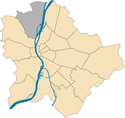
Location of District III in Budapest (shown in grey)
Coordinates: 47°34′03N 19°02′13E / 47.5674°N 19.0370°E / 47.5674; 19.0370
CountryHungary
RegionCentral Hungary
CityBudapest
Established17 November 1873
Quarters[1]

List

  • Aranyhegy-Ürömhegy-Péterhegy
  • Aquincum
  • Békásmegyer
  • Csillaghegy
  • Csúcshegy
  • Harsánylejtő
  • Hármashatár-hegy
  • Kaszásdűlő
  • Mocsárosdűlő
  • Óbuda
  • Óbuda hegyvidéke
  • Óbudai-sziget
  • Rómaifürdő
  • Solymárvölgy
  • Újlak
Government
 • MayorLászló Kiss (DK)
Area
 • Total39.7 km2 (15.3 sq mi)
 • Rank3rd
Population
 (2016)[2]
 • Total130,415
 • Rank2nd
 • Density3,285/km2 (8,510/sq mi)
Demonymharmadik kerületi ("3rd districter")
Time zoneUTC+1 (CET)
 • Summer (DST)UTC+2 (CEST)
Postal code
1031 ... 1039
Websiteobuda.hu

Óbuda-Békásmegyer is the 3rd districtofBudapest, Hungary.

Landmarks[edit]

History[edit]

The military camp, then city of Aquincum, located in part of what later became known as Óbuda, was built there by the Roman Empire. The settlement, which existed from the 1st to the 4th century, had a military and a separate civilian area. It had advanced infrastructure such as an aqueduct, a bath and two amphitheatres, one for the military and one for the civilians. Several villas belonged to the settlement, and the Roman governor had his palace on Hajógyári Island.

Politics[edit]

The current mayor of III. District of Budapest is László Kiss (DK).

The District Assembly, elected at the 2019 local government elections, is made up of 23 members (1 Mayor, 16 Individual constituencies MEPs and 6 Compensation List MEPs) divided into this political parties and alliances:[3]

Party Seats Current District Assembly
  Opposition coalition[a] 16 M                              
  BB Óbudáért-Fidesz-KDNP 6                                

List of mayors[edit]

Member Party Date
István Tarlós SZDSZ 1990–2006
Ind.
Balázs Bús Fidesz 2006–2019
László Kiss MSZP 2019–
DK

Twin towns – sister cities[edit]

Óbuda-Békásmegyer is twinned with:[4]

Notes[edit]

  1. ^ Coalition of MomentumDKMSZPDialogueLMP.

References[edit]

  1. ^ "94/2012. (XII. 27.) Főv. Kgy. rendelet - a közterület- és városrésznevek megállapításáról, azok jelöléséről, valamint a házszám-megállapítás szabályairól" (in Hungarian).
  • ^ a b "A fővárosi kerületek, a megyei jogú városok, a városok területe, lakónépessége és a lakások száma" [The area of districts of the capital, of the towns with county's rights, resident population and number of dwellings]. Magyarország közigazgatási helynévkönyve 2016. január 1 [Gazetteer of Hungary 1 January 2016] (PDF). Hungarian Central Statistical Office. 2016. p. 21.
  • ^ "Városi közgyűlés tagjai 2019-2024 - Budapest III. kerület". valasztas.hu. Retrieved 30 October 2019.
  • ^ "Testvérvárosok" (in Hungarian). Óbuda-Békásmegyer. Retrieved 12 January 2023.
  • External links[edit]


  • t
  • e

  • Retrieved from "https://en.wikipedia.org/w/index.php?title=Óbuda-Békásmegyer&oldid=1224925413"

    Categories: 
    Óbuda-Békásmegyer
    Hungary geography stubs
    Hidden categories: 
    CS1 Hungarian-language sources (hu)
    Articles with short description
    Short description is different from Wikidata
    Use dmy dates from November 2018
    Pages using gadget WikiMiniAtlas
    Commons category link is on Wikidata
    Official website different in Wikidata and Wikipedia
    Articles with NKC identifiers
    All stub articles


    This page was last edited on 21 May 2024, at 09:28 (UTC).

    Text is available under the Creative Commons Attribution-ShareAlike License 4.0; additional terms may apply. By using this site, you agree to the Terms of Use and Privacy Policy. Wikipedia® is a registered trademark of the Wikimedia Foundation, Inc., a non-profit organization.


    Privacy policy

    About Wikipedia

    Disclaimers

    Contact Wikipedia

    Code of Conduct

    Developers

    Statistics

    Cookie statement

    Mobile view


    Wikimedia Foundation
    Powered by MediaWiki